2013 Bathing Water Profile for Perranporth Village End
-
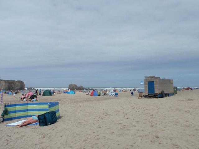
Perranporth Village End is at the southern end of Perran Sands on the north coast of Cornwall. It is a sandy beach resort approximately 700 metres wide, backed by sand dunes. A stream flows across the beach to the sea.
-
Cornwall
-
There is an emergency/storm overflow from the Station Road pumping station, that discharges into the Bolingey Stream 700m upstream of the bathing water. The operation of the overflow can lead to a drop in water quality in the Bolingey Stream and Perranporth Village End bathing water.
-
In the past the water quality at Perranporth was affected by an untreated sewage outfall near Cligga Head and unsatisfactory combined sewer overflows (CSO) discharging to the Bolingey Stream. A sewage treatment works (STW) for Perranporth was built at Cligga Head by South West Water in late 1997. The scheme included a new relocated outfall, resewerage and improvements to CSOs. The outfall from the STW was relocated again in April 2005 and treatment was upgraded to full secondary treatment and ultraviolet disinfection.
-
The urban area of Perranporth immediately behind the beach is served by a combined (surface and sewer) system. There are no outfalls from the system onto the beach. Surface water from the surrounding area can flow into the Bolingey and Perrancoombe streams which flow onto the beach. This can affect bathing water quality, particularly after periods of rainfall.
-
This bathing water does not have a history of large amounts of seaweed (macroalgae).
-
Phytoplankton (microscopic algae) naturally increase in number at certain times of the year. This process is known as a phytoplankton bloom. This bathing water does not have a history of phytoplankton blooms.
-
2013 Bathing Water Profile for Perranporth Village End
-
Streams and rivers are typically affected by human sewage, animal slurry and runoff from roads. The Bolingey and Perrancoombe streams join on the beach at Perranporth and flow into the sea at Perranporth Village End. The Environment Agency have monitored these streams upstream from where they join since 1986, and found that water quality is worse during and after heavy rainfall.
-
The outfall from Perranporth STW discharges to the sea approximately 1.3km southwest of the bathing water. This discharge is disinfected and designed to protect bathing water quality.
-
There are approximately 20 farms in the catchment, most of which are arable and livestock. During and after periods of heavy rainfall, runoff to the Bolingey and Perrancoombe streams from agricultural land is greatly increased, and the quality of the bathing water can be reduced.
-
There are caravan parks and hotels that are not on the main sewerage system and have private sewage treatment arrangements. The Environment Agency do not believe these are a source of pollution to the bathing water. If any concerns arise, the Environment Agency will investigate and request immediate remedial action from those responsible.
-
The catchment surrounding Perranporth Village End is approximately 3,650 hectares. The Bolingey and Perrancoombe streams join just before entering the bathing water. The Perrancoombe Stream is approximately 7.6 kilometres (km) long and rises just north of the A30 flowing northwards to Perranporth. The Bolingey Stream is approximately 16km long (including tributaries). The steep catchment means rain runs off rapidly into the streams. The catchment is mostly agricultural, with around 20 farms, and the rural areas are mostly improved grassland, with some arable and wooded valleys, particularly on the Bolingey Stream. Urban areas include Perranporth and Goonhavern and there are many holiday camps and caravan sites in the catchment. Much of the coastline is designated as a Site of Special Scientific Interest (SSSI) or Special Area of Conservation (SAC).
-
Perranporth
-
Perranporth
-
Sampling point at Perranporth
-
175640
-
50.34935602310362
-
-5.155098900544113
-
54700
-
Sampling point at Perranporth
-
-
-
Plymouth City Council/Cornwall County Council
-
-
Cornwall County Council
-
Plymouth City Council/Cornwall County Council
-
-
-
2013:1
-
Seaweed (macroalgae) and phytoplankton (microscopic algae) are a natural part of the marine and freshwater environment. Below we note whether these have been recorded in quantities sufficient to be a nuisance.
-
The majority of sewers in England and Wales are “combined sewers” and carry both sewage and surface water from roofs and drains. A storm overflow operates during heavy rainfall when the sewerage system becomes overwhelmed by the amount of surface water. The overflow prevents sewage from backing up pipes and flooding properties and gardens. An emergency overflow will only operate infrequently, for example due to pump failure or blockage in the sewerage system.
-
Heavy rain falling on pavements and roads often flows into surface water drains or highway drains, ending up in local rivers and, ultimately, the sea. The quality of bathing water may be adversely affected as a result of such events.
-
It is the Environment Agency and Natural Resources Wales role to drive improvement of water quality at bathing waters that are at risk of failing European standards. It is natural for water to run off the land to the sea. Water quality at a bathing water is dependent upon the type and area of land (the catchment) draining to the water and the activities undertaken in that catchment.
-
Discharges from sewage treatment works have improved substantially in England and Wales since the 1980s.
-
