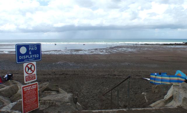
Widemouth Sand is on the north coast of Cornwall. It is a large sandy beach resort,
approximately 560 metres wide, backed by low cliffs. There are rock pools and a small
stream that flows onto the beach.
There is an emergency/storm overflow from the Madeira Drive pumping station, that
discharges 270m upstream of the beach to the small stream in the village of Widemouth
Bay. The operation of the overflow can lead to a temporary drop in bathing water quality.
This bathing water is included in the Surfers Against Sewage “Safer Seas Service”.
This service can alert you to Combined Storm Sewer Overflow discharges via a phone
App and in addition, it includes the Environment Agency Pollution Risk Forecast warnings
where they are available. Further details of the service can be found at - http://www.sas.org.uk/safer-seas-service/
In the past sewage at Bude was discharged without treatment through a short outfall
off Compass Point. The South West Water sewage treatment scheme for Bude, which provides
primary treatment and a one kilometre long sea outfall, was completed in 1993.
The Bude sewage treatment works (STW) was upgraded with secondary treatment by the
end of 2000. Improvements to the combined storm overflow (CSO) at Stratton pumping
station were also completed at that time.
Storm overflow event duration monitoring (EDM) was installed at the Madeira Drivepumping
station by April 2011.
For the four year (2015-2018) assessment period where data is available, seaweed (macroalgae)
was not assessed as being sufficient to be objectionable, but was observed as being
present on 54% of visits. The bathing water can become covered with large amounts
of seaweed, depending on tides and the weather. This bathing water does not have a
history of large amounts of seaweed, but that it can occur in noticeable quantities
from time to time.
For the four year (2015-2018) assessment period where data is available, phytoplankton
(microscopic algae) was not noted at this site. Phytoplankton (microscopic algae)
naturally increase in number at certain times of the year. This process is known as
a phytoplankton bloom. This bathing water does not have a history of phytoplankton
blooms.
The risks to human health from contact, ingestion or inhalation with marine algae
that currently occur in UK coastal waters are considered to be low. However, some
individuals may be more sensitive and display some reactions.
A common marine algae found in UK coastal waters is Phaeocystis, which is often mistaken
for sewage as it forms foam and a brown scum, but it is non-toxic.
Streams and rivers are typically affected by human sewage, animal slurry and runoff
from roads. There is a very small stream flowing onto Widemouth Sand from Widemouth
Bay village which can affect water quality after heavy rainfall.
The outfall from Bude STW discharges into the sea off Compass Point approximately
four kilometres north of Widemouth Sand bathing water. This discharge is designed
to protect bathing water quality.
Environment Agency samplers make observations of litter present on the beach at every
visit, this includes assessments of sewage debris, litter and tar. At Widemouth Sand
for the four year (2015-2018) assessment period where data is available, sewage debris
was not noted at this site. Litter was not assessed as being sufficient to be objectionable,
but was observed as being present on 46% of visits. Tarry residue was not noted at
this site.
There are two farms in the catchment which are used for livestock. During and after
periods of heavy rainfall, runoff to the stream from agricultural land is greatly
increased, and the quality of the bathing water can be reduced.
There are several caravan parks, hotels, and a car park at the southern end of the
beach, that are not on the main sewerage system and have private sewage treatment
arrangements. The Environment Agency do not believe these are a source of pollution
to the bathing water at present. If any concerns arise, the Environment Agency will
investigate and request immediate remedial action from those responsible.
The catchment surrounding Widemouth Sand is approximately 370 hectares. There is an
unnamed stream at the northern end of the beach, which is approximately two and a
half kilometres long. Land use is entirely rural with two farms and a holiday village.
Seaweed (macroalgae) and phytoplankton (microscopic algae) are a natural part of the
marine and freshwater environment. Below we note whether these have been recorded
in quantities sufficient to be a nuisance.
The majority of sewers in England are “combined sewers” and carry both sewage and
surface water from roofs and drains. A storm overflow operates during heavy rainfall
when the sewerage system becomes overwhelmed by the amount of surface water. The overflow
prevents sewage from backing up pipes and flooding properties and gardens. An emergency
overflow will only operate infrequently, for example due to pump failure or blockage
in the sewerage system.
Heavy rain falling on pavements and roads often flows into surface water drains or
highway drains, ending up in local rivers and ultimately the sea. The quality of bathing
water may be adversely affected as a result of such events.
It is the Environment Agency role to drive improvement of water quality at bathing
waters that are at risk of failing higher standards. It is natural for water to run
off the land to the sea. Water quality at a bathing water is dependent upon the type
and area of land (the catchment) draining to the water and the activities undertaken
in that catchment.


