2024 Bathing Water Profile for River Ribble at Edisford Bridge
-
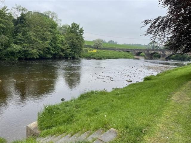
The Ribble at Edisford Bridge is a popular location for swimming, paddling and picnics, located on the River Ribble at Clitheroe in Lancashire. When the river level is low, a gently sloping shingle beach is exposed.
-
Ribble Valley District
-
Lancashire
-
The Environment Agency works with the water companies, local authorities and others to investigate any sources of contamination and to improve water quality at local bathing waters.
-
The Environment Agency works closely with United Utilities to identify and deliver significant investment in sewerage infrastructure.
-
Modern sewerage systems have two separate systems, one takes foul sewage to sewage treatment, the other takes rainwater runoff through surface water drains to rivers, lakes and the sea. Misconnections occur when waste water pipes are plumbed into surface water drains instead of the foul water sewerage system. This can give rise to pollution when the waste water is discharged directly to the environment through the surface water drain. For example, a washing machine or toilet may be incorrectly plumbed so that it discharges to the surface drain rather than the foul sewage drain.
-
This will be updated through the bathing water season.
-
There are no active pollution risk forecasts made at this bathing water. However any bathing water has the potential to be affected by a pollution incident and if this occurs a pollution risk warning with associated advice against bathing will be issued on this website.
-
2024 Bathing Water Profile for River Ribble at Edisford Bridge
-
2024-09-30
-
2024-05-01
-
Above the bathing water, the Ribble and its tributaries receive run off from both urban and rural areas which may have the potential to reduce bathing water quality. During or after periods of heavy rainfall the impact from these sources of pollution can increase the risk of reduced bathing water quality.
-
Significant improvements have been made to sewage discharges across the Ribble catchment, including Clitheroe, Blackburn and Preston.
-
Environment Agency samplers make observations of litter present on the beach at every visit, this includes assessments of sewage debris, litter and tar.
-
Agriculture is a significant land use across the Ribble catchment. During and after periods of heavy rainfall excess water may not soak into agricultural land causing runoff into the streams and rivers. The quality of the bathing water may decline as a result of such events. Part of the Environment Agency's role is to work with farmers to reduce the effects of farming on water quality. The Environment Agency provide advice to farmers on how to comply with regulations and good practice on farms to ensure that pollution entering watercourses is minimised. Natural England deliver agri-environment schemes in the catchment providing advice to farmers to enhance farming practices and reduce run off from farmland.
-
The Environment Agency works with industry and local businesses to provide advice and guidance on best practice and compliance with legislation.
-
The Environment Agency continues to work with Ribble Rivers Trust to identify and address issues from agricultural land management practises in the catchment. The Ribble Catchment Partnership delivers a range of projects to improve the water environment, including weir removal, river naturalisation and habitat creation.
-
There are a number of private discharges across the Ribble catchment from private dwellings, hotels and campsites. The Environment Agency regulates these discharges and where there is a risk to bathing water quality the Environment Agency will step in to ensure improvements are made.
-
The River Ribble flows from Ribblehead, in the Yorkshire Dales National Park, to the Irish sea near Preston in Lancashire. Significant urban areas include Blackburn, Burnley, Clitheroe and Preston. Agriculture is a key land use within the catchment, with sheep farming in the upper catchment and more intensive agriculture in the lower reaches. The Ribble and its tributaries provide good habitat for iconic species such as salmon and otters. The upper Ribblesdale area also supports significant populations of native crayfish. The Ribble Estuary is one of the largest in the UK and its wetlands are home to thousands of overwintering migratory birds, which account for its designation as a Special Protection Area.
-
River Ribble at Edisford Bridge
-
River Ribble at Edisford Bridge
-
Sampling point at River Ribble at Edisford Bridge
-
372658
-
53.86847
-
-2.41728
-
441441
-
Sampling point at River Ribble at Edisford Bridge
-
-
-
p152 dT23 h59 m59 s
-
2024 05 01 t00:00:00
-
2024-05-01T00:00:00
-
-
2024 09 30 t23:59:59
-
2024-09-30T23:59:59
-
-
-
2024 46501:1
-
Seaweed (macroalgae) and phytoplankton (microscopic algae) are a natural part of the marine and freshwater environment. Below we note whether these have been recorded in quantities sufficient to be a nuisance.
-
The majority of sewers in England are “combined sewers” and carry both sewage and surface water from roofs and drains. A storm overflow operates during heavy rainfall when the sewerage system becomes overwhelmed by the amount of surface water. The overflow prevents sewage from backing up pipes and flooding properties and gardens. An emergency overflow will only operate infrequently, for example due to pump failure or blockage in the sewerage system.
-
Heavy rain falling on pavements and roads often flows into surface water drains or highway drains, ending up in local rivers and ultimately the sea. The quality of bathing water may be adversely affected as a result of such events.
-
It is the Environment Agency role to drive improvement of water quality at bathing waters that are at risk of failing higher standards. It is natural for water to run off the land to the sea. Water quality at a bathing water is dependent upon the type and area of land (the catchment) draining to the water and the activities undertaken in that catchment.
-
Discharges from sewage treatment works have improved substantially in England since the 1980s.
-
