2024 Bathing Water Profile for Wolvercote Mill Stream
-
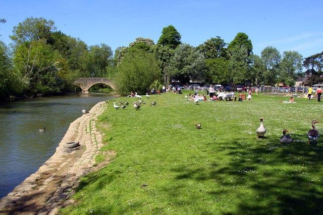
Wolvercote Mill Stream is a bifurcation of the River Thames that splits from the main channel above King's Lock, re-joining below Godstow Lock. The bathing water is in the north east corner of Port Meadow, immediately downstream of Wolvercote Bridge. Access to the swimming area is via a sloping bank, which is adjacent to the Wolvercote car park. The site is around 1 mile north of Oxford City Centre, and can be easily accessed by foot or bicycle.
-
Oxford District
-
Oxfordshire
-
The Environment Agency regularly carry out investigations to identify sources of pollution in the catchment. The Environment Agency do this by monitoring the quality of streams and visiting sites where the Environment Agency give advice on compliance with regulations and good practice as appropriate. The Environment Agency have a duty to undertake water quality monitoring for the bathing water. Over the past 2 years the Environment Agency have been undertaking further water quality investigations in the River Thames catchment upstream of Wolvercote.
-
There are a number of storm overflows that discharge into the River Thames upstream of Wolvercote Mill Stream. The closest is Cassington Sewage Treatment works, which is around 4km upstream. Beyond that there are several other CSOs on the River Thames, and tributaries such as the River Evenlode and River Windrush. The impact of these on the bathing water is currently unknown, however, when any of these outfalls are operating, they discharge diluted effluent into the river and may result in reduced bathing water quality.
-
The Environment Agency works closely with Thames Water to identify and deliver significant investment in sewerage infrastructure. The Environment Agency is supporting Thames Water and Oxford City Council to progress catchment investigations and undertaking work to minimise surface water entering the combined sewer, in order to reduce the operation of storm overflows. Thames Water, Oxford City Council and the Environment Agency will work together to investigate, and plan investment for required improvement to water quality at the bathing water.
-
Modern sewerage systems have two separate systems, one takes foul sewage to sewage treatment, the other takes rainwater runoff through surface water drains to rivers, lakes and the sea. Misconnections occur when waste water pipes are plumbed into surface water drains instead of the foul water sewerage system. This can give rise to pollution when the waste water is discharged directly to the environment through the surface water drain. For example, a washing machine or toilet may be incorrectly plumbed so that it discharges to the surface drain rather than the foul sewage drain.
-
For the two year (2022-2023) assessment period where data is available, phytoplankton (microscopic algae) was not noted at this site. Phytoplankton (microscopic algae) increase in number at certain times of the year. This process is known as a phytoplankton bloom. Blooms of phytoplankton can result in the water appearing discoloured or a foam forming on the water. If a bloom of blue-green algae is visible you are advised not to enter the water and to contact the bathing water operator.
-
There are no active pollution risk forecasts made at this bathing water. However any bathing water has the potential to be affected by a pollution incident and if this occurs a pollution risk warning with associated advice against bathing will be issued on this website.
-
2024 Bathing Water Profile for Wolvercote Mill Stream
-
2024-09-30
-
2024-05-01
-
There is a large catchment area above Wolvercote Mill Stream, which includes rivers and streams that will receive runoff from both urban and rural areas. The impact of these is currently unknown, and further investigations will be required. The Environment Agency works to improve water quality in rivers, and reduce potential sources of pollution. Diffuse runoff from agriculture and settlements upstream of the bathing water will also affect the bacteriological quality of the Wolvercote Mill Stream.
-
The closest sewage company discharge to Wolvercote Mill Stream is Cassington Sewage Treatment Works, which is around 4km upstream. This has a final effluent and storm/emergency outfall. There are several other water company discharges upstream of Wolvercote Mill Stream, both on the River Thames, and major tributaries such as the River Evenlode and River Windrush. Further investigation is required to understand the impact of these discharges on the bathing water.
-
Environment Agency samplers make observations of litter present on the beach at every visit, this includes assessments of sewage debris, litter and tar. At Wolvercote Mill Stream for the two year (2022-2023) assessment period where data is available, sewage debris was not noted at this site. Litter was assessed as being sufficient to be objectionable for 2% of visits, with 37% of visits noting the presence of litter. Tarry residue was not noted at this site.
-
Part of the Environment Agency's role is to work with farmers to reduce the effects of farming on water quality. The Environment Agency provide advice to farmers on how to comply with regulations and good practice on farms to ensure that pollution entering watercourses is minimised. The River Thames catchment, upstream of Wolvercote Mill Stream, is largely agricultural, with a combination of arabal of livestock farming. During and after periods of heavy rainfall, runoff from agricultural areas will be greatly increased and this may adversely affect the quality of the bathing water.
-
The Environment Agency works with industry and local businesses to provide advice and guidance on best practice.
-
There are a number of private sewage treatment plants within the catchment and the Environment Agency continues to work with the owners to ensure that these are adequately maintained and do not impact on the water quality of the streams they discharge to.
-
The River Thames above Oxford is a relatively slow flowing, lowland river. The Upper Thames from its source to Oxford flows through a predominantly rural landscape, and does not pass through any major towns before reaching Oxford. Notable tributaries are the Leach, Windrush, and Evenlode, with some of these flowing through major settlements such as Swindon and Witney. The upper reaches of the Thames and the majority of its main tributaries arise in the Cotswolds and are good quality streams fed from limestone springs. The river ecology is notably impacted by agriculture, but also has significant pressures arising from population and physical modification. The large public water abstraction for Farmoor reservoir is located a few KMs upstream of Wolvercote Mill Stream. The River Thames is a managed, navigable waterway, with the habitat being dominated by navigational requirements with locks and weirs impounding reaches. As a result fish populations can vary depending on the quality and variety of habitat. Due to the navigable nature of the river, boating, rowing and canoeing are prominent activities. The Wolvercote Mill Stream is part of the Oxford Watercourses, a complex series of streams in and around the Oxford area which are distributaries of the Thames. Some of these support very valuable flow dependant habitat, including important fish spawning and nursery sites. A number of weirs and sluices are also located on these watercourses and are used to maintain water levels to ensure that the Thames is navigable. In times of low flow, arrangements are put in place to ensure these structures are carefully managed to ensure the flows to the watercourses that support critical habitat are protected as much as possible. The Oxford area has a long history of flooding, with recent notable incidents being in 2003, 2007 and 2013/14.
-
Wolvercote Mill Stream
-
Wolvercote Mill Stream
-
Sampling point at Wolvercote Mill Stream
-
448665
-
51.78081990807167
-
-1.295961521722681
-
209362
-
Sampling point at Wolvercote Mill Stream
-
-
-
p152 dT23 h59 m59 s
-
2024 05 01 t00:00:00
-
2024-05-01T00:00:00
-
-
2024 09 30 t23:59:59
-
2024-09-30T23:59:59
-
-
-
2024 11946:1
-
Seaweed (macroalgae) and phytoplankton (microscopic algae) are a natural part of the marine and freshwater environment. Below we note whether these have been recorded in quantities sufficient to be a nuisance.
-
The majority of sewers in England are “combined sewers” and carry both sewage and surface water from roofs and drains. A storm overflow operates during heavy rainfall when the sewerage system becomes overwhelmed by the amount of surface water. The overflow prevents sewage from backing up pipes and flooding properties and gardens. An emergency overflow will only operate infrequently, for example due to pump failure or blockage in the sewerage system.
-
Heavy rain falling on pavements and roads often flows into surface water drains or highway drains, ending up in local rivers and ultimately the sea. The quality of bathing water may be adversely affected as a result of such events.
-
There are no active pollution risk forecasts made at this bathing water. However any bathing water has the potential to be affected by a pollution incident and if this occurs a pollution risk warning with associated advice against bathing will be issued on this website.
-
Discharges from sewage treatment works have improved substantially in England since the 1980s.
-
