2024 Bathing Water Profile for Tankerton
-
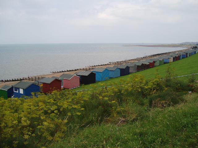
Tankerton is situated on the North Kent coast. The shingle beach is gently sloping, flattening to a wide expanse of sand and mud that is exposed when the tide retreats. The bathing water contains numerous groynes and is backed by a promenade and a wide, grassy bank (Tankerton Slopes) behind which lies the town of Tankerton.
-
Canterbury District
-
Kent
-
Tankerton Outfall storm overflow is just west of the bathing water (550 metres west of the sampling point) and there is an emergency/storm overflow at the Gorrell outfall 1.3 km west of the bathing water sampling point. Swalecliffe storm overflow outfall is 1.6 km north east of the bathing water sampling point. These may discharge when heavy rainfall overwhelms the sewerage system and causes diluted sewage to overflow. The discharges are designed to protect bathing water compliance.
-
Swalecliffe Long Sea Outfall (3km north east of the bathing water) was upgraded to further treatment in 2001and later received ultraviolet disinfection to protect shellfish water quality.
-
For the four year (2020-2023) assessment period where data is available, seaweed (macroalgae) was not assessed as being sufficient to be objectionable, but was observed as being present on 91% of visits. The bathing water can become covered with seaweed, depending on tides and the weather. Groynes, rocks and other fixed objects may have a covering of seaweed which can be slippery.
-
Modern sewerage systems have two separate systems, one takes foul sewage to sewage treatment, the other takes rainwater runoff through surface water drains to rivers, lakes and the sea. Misconnections occur when waste water pipes are plumbed into surface water drains instead of the foul water sewerage system. This can give rise to pollution when the waste water is discharged directly to the environment through the surface water drain. For example, a washing machine or toilet may be incorrectly plumbed so that it discharges to the surface drain rather than the foul sewage drain.
-
For the four year (2020-2023) assessment period where data is available, phytoplankton (microscopic algae) was not noted at this site. Phytoplankton (microscopic algae) increase in number at certain times of the year. This process is known as a phytoplankton bloom. Blooms of phytoplankton can result in the water appearing discoloured or a foam forming on the water. The risks to human health from contact, ingestion or inhalation with marine algae that currently occur in UK coastal waters are considered to be low. However, some individuals may be more sensitive and display some reactions. A common marine algae found in UK coastal waters is Phaeocystis, which is often mistaken for sewage as it forms foam and a brown scum, but it is non-toxic.
-
This bathing water is subject to short term pollution procedures. The Environment Agency makes a daily pollution risk forecast at this site based on the effects of rain, wind and seasonality on bathing water quality. These factors affect the levels of bacteria that get washed into the sea from livestock, sewage and urban drainage via rivers and streams and how they disperse. When these factors combine to make short term pollution likely we issue a pollution risk warning on this website and the beach manager will display a sign advising against bathing at the bathing water. After a short term pollution event, levels of bacteria typically return to normal after a day or so but it’s possible to have several warning days in a row. Details of the work to reduce the sources of bacteria at this bathing water are detailed in this profile. In 2023 3 pollution risk warnings were issued for this bathing water. All bathing waters have the potential to be affected by a pollution incident and if this occurs a pollution risk warning will be issued with associated advice against bathing on this website.
-
2024 Bathing Water Profile for Tankerton
-
2024-09-30
-
2024-05-01
-
There are no riverine inputs into the bathing water but the Gorrell stream, which receives sewage and storm/emergency overflows, inputs into Whitstable Harbour just 1.5 km west of the bathing water sampling point. There is stream that inputs to sea 1.4 km east of the bathing water sampling point that receives a storm overflow input, and a drainage ditch that inputs to sea 2 km east of the bathing water sampling point. The mouth of the Swale (which separates the Isle of Sheppey from the mainland) is a few km to the west.
-
Swalecliffe Long Sea Outfall discharges further treated, ultraviolet disinfected sewage effluent 3 km northeast of the bathing water sampling point. The ultraviolet treatment was installed to protect shellfish water quality but also affords additional protection to bathing water quality.
-
Environment Agency samplers make observations of litter present on the beach at every visit, this includes assessments of sewage debris, litter and tar. At Tankerton for the four year (2020-2023) assessment period where data is available, sewage debris was not assessed as being sufficient to be objectionable, but was observed as being present on 2% of visits. Litter was not assessed as being sufficient to be objectionable, but was observed as being present on 67% of visits. Tarry residue was not noted at this site.
-
The natural drainage (hydrological) catchment surrounding the bathing water is small at approximately 60 hectares. The catchment is predominantly urban, comprising part of the town of Tankerton.
-
Tankerton
-
Tankerton
-
Sampling point at Tankerton
-
612120
-
51.36543634344041
-
1.045826991432158
-
167333
-
Sampling point at Tankerton
-
-
-
p152 dT23 h59 m59 s
-
2024 05 01 t00:00:00
-
2024-05-01T00:00:00
-
-
2024 09 30 t23:59:59
-
2024-09-30T23:59:59
-
-
-
2024 12120:1
-
Seaweed (macroalgae) and phytoplankton (microscopic algae) are a natural part of the marine and freshwater environment. Below we note whether these have been recorded in quantities sufficient to be a nuisance.
-
The majority of sewers in England are “combined sewers” and carry both sewage and surface water from roofs and drains. A storm overflow operates during heavy rainfall when the sewerage system becomes overwhelmed by the amount of surface water. The overflow prevents sewage from backing up pipes and flooding properties and gardens. An emergency overflow will only operate infrequently, for example due to pump failure or blockage in the sewerage system.
-
Heavy rain falling on pavements and roads often flows into surface water drains or highway drains, ending up in local rivers and ultimately the sea. The quality of bathing water may be adversely affected as a result of such events.
-
It is the Environment Agency role to drive improvement of water quality at bathing waters that are at risk of failing higher standards. It is natural for water to run off the land to the sea. Water quality at a bathing water is dependent upon the type and area of land (the catchment) draining to the water and the activities undertaken in that catchment.
-
Discharges from sewage treatment works have improved substantially in England since the 1980s.
-
