2019 Bathing Water Profile for Burnham Jetty North
-
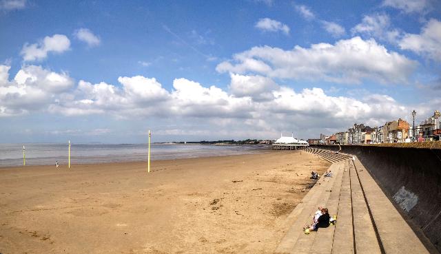
Burnham Jetty North is within Bridgwater Bay, part of the Somerset coast overlooking the Bristol Channel. It is a sand and mud beach resort, approximately 2.2 kilometres wide and backed by a sea defence wall. The beach has a shallow slope and a very large tidal range (11 metres). At low tide, the sea lies up to half a kilometre from the beach, inaccesible on foot due to the dangerous intertidal mudflats. The rivers Brue and Parrett both flow into the Bay just south of the bathing water. Bridgwater Bay is a National Nature Reserve; an important habitat for wading birds and many rare insects.
-
Sedgemoor
-
Somerset
-
The Environment Agency have been working over a number of years to investigate the sources of pollution to this bathing water. In recent years, the Environment Agency has carried out investigative sampling in the catchments of the River Brue, Parrett and Huntspill along with walkovers in wet and dry conditions. A spatial sampling programme along the length of the beach has also been completed to identify locations of higher pollution levels. Investigations have shown both agricultural and sewage sources contribute to the poor water quality at Burnham. We have worked with Wessex Water to investigate the impact of their assets on bathing water quality which has resulted in a number of improvement to their assets. In recent years we have also worked with Wessex Water Streamclean to investigate, identify and improve misconnections to the surface water system. Each year we carry out pre-season surveys of the rivers and outfalls that have potential to impact the beach. The Environment Agency continues to work with Natural England and farmers and landowners in the river catchments through the Catchment Sensitive Farming programme to encourage better farming practices and improve water quality.
-
There are no storm or emergency overflows directly affecting Burnham Jetty North bathing water. Within the catchment there are storm and emergency overflows that discharge to the rivers and ditches. Closest to the bathing water are the Highbridge storm tanks which discharge to the tidal River Brue, and West Huntspill STW which has an emergency overflow to the River Parrett. The overflows can lead to a drop in water quality in the rivers and at the bathing water. This bathing water is included in the Surfers Against Sewage “Safer Seas Service”. This service can alert you to Combined Storm Sewer Overflow discharges via a phone App and in addition, it includes the Environment Agency Pollution Risk Forecast warnings where they are available. Further details of the service can be found at - http://www.sas.org.uk/safer-seas-service/
-
In the past this bathing water was affected by discharges from West Huntspill sewage treatment works (STW) and Bridgwater STW. The Wessex Water sewage treatment scheme for West Huntspill, which provides secondary treatment, was partially completed in 1997. Ultraviolet (UV) disinfection was added in 2000. The Wessex Water sewage treatment scheme for Bridgwater, which provides secondary treatment and UV disinfection, was also completed in 2000. Improvements were made to the storm overflows at three pumping stations in Bridgwater by the end of 2002, and the storage capacity of the Highbridge storm tanks was increased in 2004 to reduce discharge frequency and volume. Improvements were made to eight storm overflows in Bridgwater and a storm overflow in Burnham in 2005. The Environment Agency has been working with Wessex Water to review sewerage performance within the catchment area. Wessex Water added ultra-violet (UV) treatment to the storm-related discharge from Highbridge storm tanks in February 2016. Works to increase storm storage capacity to reduce the occurrence of wet weather sewage spills have also been completed during 2017/18 at Sloway Lane Pumping Station near Highbridge and 6 other locations in Bridgwater. Improvements to existing sewage treatment processes were completed in 2018 at Cannington STW with increased storm storage capacity and the addition of UV treatment on the final effluent discharge. Combwich STW ceased discharging to the estuary in 2018 and is instead pumped to Cannington STW for treatment. The Environment Agency is also working with Wessex Water to reduce infiltration of surface water run‐off into combined sewers, further reducing the risk of sewage overflow during wet weather. The Environment Agency will continue to make recommendations for further improvements to protect and improve the bathing water quality.
-
The urban area of Burnham immediately behind the beach is served by a combined (surface and sewer) system. Surface water can flow into the River Brue and onto the beach from highways drains, surface water drains and rhynes (drainage ditches). This can affect bathing water quality, particularly after periods of rainfall. The Environment Agency have regularly inspected and sampled surface water outfalls. As with many bathing waters close to urban centres, significant proportion of bathing water pollutants originate from poor practices by local residents, businesses and visitors. The Environment Agency has worked closely with Sedgemoor District Council on several public engagement activities since 2012 to promote best practice and reduce the impact of misconnections, poorly disposed of sanitary products, pet waste and other issues that block sewers or directly contaminate bathing water. The Environment Agency, Sedgemoor District Council, Wessex Water and Dorset Coastal Forum are supporting the 'Litter Free Coast & Sea Somerset' project led by Severn Estuary Partnership to engage tourists and the Burnham community on bathing water issues and solutions.
-
For the four year (2015-2018) assessment period where data is available, seaweed (macroalgae) was assessed as being sufficient to be objectionable for 15% of visits, with 74% of visits noting the presence of seaweed (macroalgae). The bathing water can become covered with large amounts of seaweed, depending on tides and the weather. This bathing water does have seaweed on the beach but not in significant quantities. Groynes and rocks, platforms or other fixed objects may also develop a covering of seaweed which can be slippery.
-
Wrongly connected domestic waste water pipes can also affect the bathing water quality. Modern sewerage systems have two separate systems, one takes foul sewage to sewage treatment, the other takes rainwater runoff through surface water drains to rivers, lakes and the sea. Misconnections occur when waste water pipes are plumbed into surface water drains instead of the foul water sewerage system. This can give rise to pollution when the waste water is discharged directly to the environment through the surface water drain. For example, a washing machine or toilet may be incorrectly plumbed so that it discharges to the surface drain rather than the foul sewage drain. The Environment Agency has identified many misconnected local properties across the catchment, and continues to work with Wessex Water to locate and rectify these problems.
-
For the four year (2015-2018) assessment period where data is available, phytoplankton (microscopic algae) was not assessed as being sufficient to be objectionable, but was observed as being present on 1% of visits. Phytoplankton (microscopic algae) naturally increase in number at certain times of the year. This process is known as a phytoplankton bloom. This bathing water does not have a history of phytoplankton blooms. The risks to human health from contact, ingestion or inhalation with marine algae that currently occur in UK coastal waters are considered to be low. However, some individuals may be more sensitive and display some reactions. A common marine algae found in UK coastal waters is Phaeocystis, which is often mistaken for sewage as it forms foam and a brown scum, but it is non-toxic.
-
This bathing water is subject to short term pollution. Short term pollution is caused when heavy rainfall or high tides wash faecal material into the sea from livestock, sewage and urban drainage via rivers and streams. At this site the risk of encountering reduced water quality increases after rainfall and typically returns to normal after 1-3 days. The Environment Agency makes daily pollution risk forecasts based on rainfall and tidal patterns and will issue a pollution risk warning if high tides or heavy rainfall occurs to enable bathers to avoid periods of increased risk. The Environment Agency works to reduce the sources of this pollution through pollution prevention measures, work with agriculture and water companies. 44 warnings advising against swimming due to an increase risk of short term pollution were issued in 2018 for Burnham Jetty North bathing water. These warnings were issued because of the effects of heavy rain and high tides on the water quality.
-
2019 Bathing Water Profile for Burnham Jetty North
-
2019-09-30
-
2019-05-01
-
The River Brue and the River Parrett are the main sources of freshwater to Bridgwater Bay. The River Brue enters the sea one kilometre south of the Environment Agency monitoring point. The River Parrett enters the sea two kilometres south of the Environment Agency monitoring point but flows across the beach at low tide. During and after periods of heavy rainfall, runoff from agricultural and urban areas is greatly increased, and the quality of the rivers and the bathing water may be reduced.
-
Sewage from Burnham area is pumped to West Huntspill STW for treatment. The outfall from Bridgwater, West Huntspill and Cannington STW discharge into the River Parrett at least two kilometres from Burnham Jetty beach. Wessex Water added UV treatment to the Highbridge storm tanks discharge in February 2016 and have added extra wet weather storage and UV treatment at Cannington STW which was completed in April 2018. These discharges are designed to protect bathing water quality.
-
Environment Agency samplers make observations of litter present on the beach at every visit, this includes assessments of sewage debris, litter and tar. At Burnham Jetty North for the four year (2015-2018) assessment period where data is available, sewage debris was assessed as being sufficient to be objectionable for 1% of visits, with 11% of visits noting the presence of sewage debris. Litter was assessed as being sufficient to be objectionable for 19% of visits, with 72% of visits noting the presence of litter. Tarry residue was not noted at this site.
-
The Burnham Jetty North catchment is partly agricultural with areas of land used for livestock. During and after periods of heavy rainfall, runoff from agricultural land is greatly increased, and the quality of the bathing water can be reduced. The Environment Agency are working with Natural England and farmers on Catchment Sensitive Farming programmes to encourage better farming practices and improve water quality in the surrounding areas.
-
There is some light industry within this catchment. The Environment Agency has worked with businesses on industrial estates in Bridgwater and Highbridge to ensure there is no affect on the bathing water quality from these sites.
-
There are some caravan parks, houses and small businesses that are not on the main sewerage system and have private sewage treatment arrangements. If any concerns arise, the Environment Agency will investigate and request immediate remedial action from those responsible.
-
The catchment surrounding Burnham Jetty North is approximately 222,000 hectares. The Parrett, Huntspill and Brue rivers flow from the steep uplands of the Quantocks, Blackdown Hills and Mendips. The rivers flow north and west into the extensive low-lying floodplain of the Somerset Levels and Moors through various man-made drainage channels to the Severn Estuary at Bridgwater Bay. The steep catchment means rain runs off rapidly into the rivers. Rivers and other streams in the Somerset Levels are controlled by sluices which manage the volume of freshwater entering Bridgwater Bay The River Parrett is 60km long and flows through Dorset and Somerset to its mouth at Burnham-on-Sea. The main tributaries of the Parrett are the rivers Isle, Tone, Yeo and Cary. The Tone joins the tidal Parrett 30km inland at Burrowbridge. The River Cary rises at Castle Cary and flows west into the man-made King’s Sedgemoor Drain at Henley Corner. It continues across the Somerset Moors and joins the tidal River Parrett downstream of Bridgwater at Dunball Sluice. The River Huntspill is a man-made river in the Sedgemoor district of the Somerset Levels that joins the River Parrett just south of Highbridge. The river was built to act as a long reservoir to provide an all year-round supply of water for the Royal Ordnance Factory near Puriton, as well as to help drain parts of the lower Brue Valley. The River Brue rises in Somerset and falls quickly in a narrow valley to a point just beyond Bruton where it is joined by the River Pitt. To the northeast of Glastonbury, the Brue is joined by various man-made drainage channels before entering the Bristol Channel. The catchment is mostly rural, with urban areas making up only five per cent of the total. The majority of the land is used for large scale agriculture, with more than 1000 farms.
-
Burnham Jetty North
-
Burnham Jetty North
-
Sampling point at Burnham Jetty North
-
330322
-
51.23565347114896
-
-2.999431565704091
-
148972
-
Sampling point at Burnham Jetty North
-
-
-
p152 dT23 h59 m59 s
-
2019 05 01 t00:00:00
-
2019-05-01T00:00:00
-
-
2019 09 30 t23:59:59
-
2019-09-30T23:59:59
-
-
-
2019 35300:1
-
Seaweed (macroalgae) and phytoplankton (microscopic algae) are a natural part of the marine and freshwater environment. Below we note whether these have been recorded in quantities sufficient to be a nuisance.
-
The majority of sewers in England are “combined sewers” and carry both sewage and surface water from roofs and drains. A storm overflow operates during heavy rainfall when the sewerage system becomes overwhelmed by the amount of surface water. The overflow prevents sewage from backing up pipes and flooding properties and gardens. An emergency overflow will only operate infrequently, for example due to pump failure or blockage in the sewerage system.
-
Heavy rain falling on pavements and roads often flows into surface water drains or highway drains, ending up in local rivers and ultimately the sea. The quality of bathing water may be adversely affected as a result of such events.
-
It is the Environment Agency role to drive improvement of water quality at bathing waters that are at risk of failing higher standards. It is natural for water to run off the land to the sea. Water quality at a bathing water is dependent upon the type and area of land (the catchment) draining to the water and the activities undertaken in that catchment.
-
Discharges from sewage treatment works have improved substantially in England since the 1980s.
-
