2024 Bathing Water Profile for Chapel Porth
-
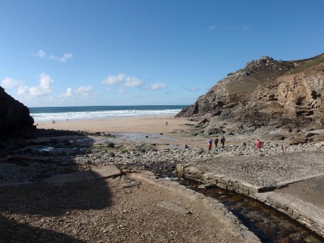
Chapel Porth is on the north coast of Cornwall, approximately three kilometres from St Agnes. At high tide the beach is a small sand and shingle cove approximately 130 metres wide. At low tide a large stretch of sandy beach approximately one kilometre wide is exposed between Tubby's Head and the neighbouring beach at Porthtowan. The beach is backed by large moorland covered cliffs which are dotted with caves and several natural arches.
-
Cornwall
-
Cornwall
-
There is no water company scheme associated directly with this bathing water.
-
For the four year (2020-2023) assessment period where data is available, seaweed (macroalgae) was assessed as being sufficient to be objectionable for 4% of visits, with 54% of visits noting the presence of seaweed (macroalgae). This bathing water does not have a history of large amounts of seaweed (macro algae).
-
For the four year (2020-2023) assessment period where data is available, phytoplankton (microscopic algae) was not noted at this site. Phytoplankton (microscopic algae) naturally increase in number at certain times of the year. This process is known as a phytoplankton bloom. This bathing water does not have a history of phytoplankton blooms. The risks to human health from contact, ingestion or inhalation with marine algae that currently occur in UK coastal waters are considered to be low. However, some individuals may be more sensitive and display some reactions. A common marine algae found in UK coastal waters is Phaeocystis, which is often mistaken for sewage as it forms foam and a brown scum, but it is non-toxic.
-
There are no active pollution risk forecasts made at this bathing water. However any bathing water has the potential to be affected by a pollution incident and if this occurs a pollution risk warning with associated advice against bathing will be issued on this website.
-
2024 Bathing Water Profile for Chapel Porth
-
2024-09-30
-
2024-05-01
-
Streams and rivers are typically affected by human sewage, animal slurry and runoff from roads. The Chapel Coombe stream flows onto this beach.
-
Environment Agency samplers make observations of litter present on the beach at every visit, this includes assessments of sewage debris, litter and tar. At Chapel Porth for the four year (2020-2023) assessment period where data is available, sewage debris was not assessed as being sufficient to be objectionable, but was observed as being present on 4% of visits. Litter was not assessed as being sufficient to be objectionable, but was observed as being present on 33% of visits. Tarry residue was not noted at this site.
-
There are nine farms in the catchment, most of which are arable and dairy. During and after periods of heavy rainfall, runoff to the streams from agricultural land is greatly increased, and the quality of the bathing water can be reduced.
-
The catchment surrounding Chapel Porth is approximately 460 hectares. The Chapel Coombe stream enters the sea at the bathing water. The steep catchment means rain runs off rapidly into the streams. The Chapel Porth catchment is an old mining valley with several disused tin and copper mines including the Charlotte United Mines. There are small urban settlements at Goonvrea and Mingoose along with several other properties dispersed around the catchment. Land use is mainly agricultural, with approximately nine farms and several campsites. The catchment is within a number of national and international designations including, the Cornwall Area of Outstanding Natural Beauty (AONB), the Godrevy Head to St Agnes Site of Special Scientific Interest (SSSI) and Special Area of Conservation (SAC), and the St Agnes Heritage Coast.
-
Chapel Porth
-
Chapel Porth
-
Sampling point at Chapel Porth
-
169729
-
50.30041024758236
-
-5.234876016017111
-
49503
-
Sampling point at Chapel Porth
-
-
-
p152 dT23 h59 m59 s
-
2024 05 01 t00:00:00
-
2024-05-01T00:00:00
-
-
2024 09 30 t23:59:59
-
2024-09-30T23:59:59
-
-
-
2024 31650:1
-
Seaweed (macroalgae) and phytoplankton (microscopic algae) are a natural part of the marine and freshwater environment. Below we note whether these have been recorded in quantities sufficient to be a nuisance.
-
The majority of sewers in England are “combined sewers” and carry both sewage and surface water from roofs and drains. A storm overflow operates during heavy rainfall when the sewerage system becomes overwhelmed by the amount of surface water. The overflow prevents sewage from backing up pipes and flooding properties and gardens. An emergency overflow will only operate infrequently, for example due to pump failure or blockage in the sewerage system.
-
Heavy rain falling on pavements and roads often flows into surface water drains or highway drains, ending up in local rivers and ultimately the sea. The quality of bathing water may be adversely affected as a result of such events.
-
It is the Environment Agency role to drive improvement of water quality at bathing waters that are at risk of failing higher standards. It is natural for water to run off the land to the sea. Water quality at a bathing water is dependent upon the type and area of land (the catchment) draining to the water and the activities undertaken in that catchment.
-
Discharges from sewage treatment works have improved substantially in England since the 1980s.
-
