2024 Bathing Water Profile for Porthcothan
-
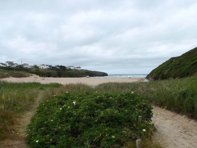
Porthcothan Bay is on the north coast of Cornwall. It is a rural, sheltered sandy bay, approximately 400 metres wide, backed by sand dunes. There is a stream that flows across the beach. Porthcothan is popular with tourists and surfers and is patrolled by lifeguards during the day in the summer.
-
Cornwall
-
Cornwall
-
The Environment Agency carried out additional monitoring of the Porthcothan Stream in 2010. This found that during and after periods of heavy rainfall, water quality could be greatly reduced due to increased runoff from agricultural land.
-
For the four year (2020-2023) assessment period where data is available, seaweed (macroalgae) was assessed as being sufficient to be objectionable for 11% of visits, with 76% of visits noting the presence of seaweed (macroalgae). The bathing water can become covered with large amounts of seaweed, depending on tides and the weather. This bathing water does not have a history of large amounts of seaweed, but that it can be noticeable from time to time.
-
For the four year (2020-2023) assessment period where data is available, phytoplankton (microscopic algae) was not assessed as being sufficient to be objectionable, but was observed as being present on 2% of visits. Phytoplankton (microscopic algae) naturally increase in number at certain times of the year. This process is known as a phytoplankton bloom. This bathing water does not have a history of phytoplankton blooms. The risks to human health from contact, ingestion or inhalation with marine algae that currently occur in UK coastal waters are considered to be low. However, some individuals may be more sensitive and display some reactions. A common marine algae found in UK coastal waters is Phaeocystis, which is often mistaken for sewage as it forms foam and a brown scum, but it is non-toxic.
-
This bathing water is subject to short term pollution procedures. The Environment Agency makes a daily pollution risk forecast at this site based on the effects of rain, tide and seasonality on bathing water quality. These factors affect the levels of bacteria that get washed into the sea from livestock, sewage and urban drainage via rivers and streams and how they disperse. When these factors combine to make short term pollution likely we issue a pollution risk warning on this website and the beach manager will display a sign advising against bathing at the bathing water. After a short term pollution event, levels of bacteria typically return to normal after a day or so but it's possible to have several warning days in a row. Details of the work to reduce the sources of bacteria at this bathing water are detailed in this profile. In 2023 2 pollution risk warnings were issued for this bathing water. All bathing waters have the potential to be affected by a pollution incident and if this occurs a pollution risk warning will be issued with associated advice against bathing on this website.
-
2024 Bathing Water Profile for Porthcothan
-
2024-09-30
-
2024-05-01
-
Streams and rivers are typically affected by human sewage, animal slurry and runoff from roads. The Porthcothan Stream flows onto this beach. The Environment Agency have monitored the stream between 1993 and 2014, and found that water quality is temporarily worse after heavy rainfall.
-
Environment Agency samplers make observations of litter present on the beach at every visit, this includes assessments of sewage debris, litter and tar. At Porthcothan for the four year (2020-2023) assessment period where data is available, sewage debris was not noted at this site. Litter was assessed as being sufficient to be objectionable for 2% of visits, with 45% of visits noting the presence of litter. Tarry residue was not noted at this site.
-
There are approximately 20 farms in the catchment, most of which are used for livestock. During and after periods of heavy rainfall, runoff to the Porthcothan Stream from agricultural land is greatly increased, and the quality of the bathing water can be reduced.
-
The catchment surrounding Porthcothan is approximately 1,500 hectares. The Porthcothan Stream is approximately seven kilometres (km) (13.5km long including tributaries) and rises close to Bear's Downs. The steep catchment means rain runs off rapidly into the stream. The catchment is agricultural, with around 20 farms. The rural areas are a patchwork of improved grassland and arable. The catchment includes the settlements of St Eval and Porthcothan as well as several smaller villages and at least four caravan sites.
-
Porthcothan
-
Porthcothan
-
Sampling point at Porthcothan
-
185720
-
50.509016460983155
-
-5.023542515803301
-
72060
-
Sampling point at Porthcothan
-
-
-
p152 dT23 h59 m59 s
-
2024 05 01 t00:00:00
-
2024-05-01T00:00:00
-
-
2024 09 30 t23:59:59
-
2024-09-30T23:59:59
-
-
-
2024 32550:1
-
Seaweed (macroalgae) and phytoplankton (microscopic algae) are a natural part of the marine and freshwater environment. Below we note whether these have been recorded in quantities sufficient to be a nuisance.
-
The majority of sewers in England are “combined sewers” and carry both sewage and surface water from roofs and drains. A storm overflow operates during heavy rainfall when the sewerage system becomes overwhelmed by the amount of surface water. The overflow prevents sewage from backing up pipes and flooding properties and gardens. An emergency overflow will only operate infrequently, for example due to pump failure or blockage in the sewerage system.
-
Heavy rain falling on pavements and roads often flows into surface water drains or highway drains, ending up in local rivers and ultimately the sea. The quality of bathing water may be adversely affected as a result of such events.
-
It is the Environment Agency role to drive improvement of water quality at bathing waters that are at risk of failing higher standards. It is natural for water to run off the land to the sea. Water quality at a bathing water is dependent upon the type and area of land (the catchment) draining to the water and the activities undertaken in that catchment.
-
Discharges from sewage treatment works have improved substantially in England since the 1980s.
-
