2015 Bathing Water Profile for Rock
-
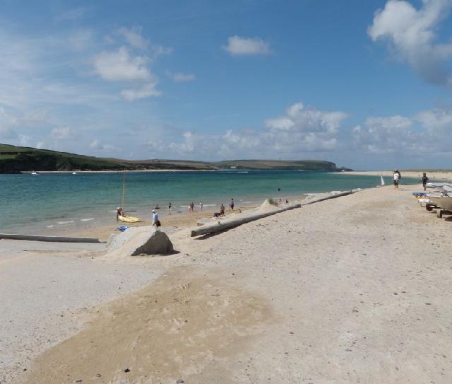
Rock Beach is on the north coast of Cornwall on the eastern side of the Camel Estuary opposite the town of Padstow. It is a sandy beach resort approximately 800 metres wide. It is intertidal and backed by sand dunes, which at low water extend for three kilometres past Brea Hill to Daymer Bay.
-
Cornwall
-
The Environment Agency have carried out extensive additional catchment monitoring alongside the Environment Agency routine bathing water monitoring. The Environment Agency are using a DNA tracing technique to help us identify whether sources of faecal pollution are animal or human with surveys carried out in wet and dry weather conditions. The Environment Agency have also walked up the catchment to identify potential sources of pollution in the Camel Estuary including misconnections, poorly maintained private sewerage systems, leaking sewers and unsuitable farming practices.
-
There is an emergency/storm overflow from the Rock pumping station, that discharges to the estuary 350m from the Environment Agency monitoring point. The operation of the overflow can lead to a drop in bathing water quality near Rock bathing water. This bathing water is included in the Surfers Against Sewage “Safer Seas Service”. This service can alert you to Combined Storm Sewer Overflow discharges via a phone App and in addition, it includes the Environment Agency Pollution Risk Forecast warnings. Further details of the service can be found at - http://www.sas.org.uk/safer-seas-service/
-
The South West Water sewage treatment scheme known as the Trevone Scheme collects sewage from the various settlements around the Camel Estuary. It is split into two schemes centred on the Porthilly sewage treatment works (STW) (East Bank Scheme), and a works at Trecerus near Padstow (West Bank Scheme). Porthilly STW received ultraviolet (UV) disinfection in 1996 for sewage from Rock, Polzeath, and Tredrizzick, and improvements were made to the sewerage in Rock and Polzeath. Trecerus STW was completed for the 1997 bathing season with chemically assisted sedimentation and ultraviolet (UV) disinfection for sewage from St Merryn, Trevone and Padstow. Improvements were also made to the sewerage in Padstow, St Merryn, Harlyn and Trevone at that time. The treatment was subsequently upgraded to full secondary treatment and UV disinfection by April 2004. Improvements to seven storm overflows to the Camel Estuary at Padstow Harbour, Rock pumping station (PS), Eddystone Road (Wadebridge PS), and Porthilly combined sewer overflow (CSO) were also completed by April 2004, and improvements to Padstow South Quay CSO, Moyles Road and Egloshayle PS were completed by August 2004. The installation of UV disinfection at Wadebridge STW was completed by July 2004.
-
The urban area of Rock immediately behind the beach is served by a combined (surface and sewer) system. Surface water can flow into the River Camel Estuary from urban areas, outfall pipes and highway drains. This can affect bathing water quality, particularly after periods of rainfall.
-
This bathing water does not have a history of large amounts of seaweed (macro algae).
-
Wrongly connected domestic waste water pipes can also affect the bathing water quality. Modern sewerage systems have two separate systems, one takes foul sewage to sewage treatment, the other takes rainwater runoff through surface water drains to rivers, lakes and the sea. Misconnections occur when waste water pipes are plumbed into surface water drains instead of the foul water sewerage system. This can give rise to pollution when the waste water is discharged directly to the environment through the surface water drain. For example, a washing machine or toilet may be incorrectly plumbed so that it discharges to the surface drain rather than the foul sewage drain.
-
Phytoplankton (microscopic algae) naturally increase in number at certain times of the year. This process is known as a phytoplankton bloom. This bathing water does not have a history of phytoplankton blooms.
-
This bathing water is subject to short term pollution. Short term pollution is caused when heavy rainfall washes faecal material into the sea from livestock, sewage and urban drainage via rivers and streams. At this site the risk of encountering reduced water quality increases after rainfall and typically returns to normal after 1-3 days. The Environment Agency makes daily pollution risk forecasts based on rainfall patterns and will issue a pollution risk warning if heavy rainfall occurs to enable bathers to avoid periods of increased risk. The Environment Agency works to reduce the sources of this pollution through pollution prevention measures, work with agriculture and water companies. 17 warnings advising against swimming due to an increase risk of short term pollution were issued in 2015 for Rock bathing water. These warnings were issued because of the effects of heavy rain on the water quality.
-
2015 Bathing Water Profile for Rock
-
2015-09-30
-
2015-05-01
-
Streams and rivers are typically affected by human sewage, animal slurry and runoff from roads. Rock bathing water is in the Camel Estuary, where water quality is worse during and after heavy rainfall.
-
The outfall from the Porthilly STW discharges to the River Camel Estuary approximately 1.2km southeast of the bathing water. This discharge is disinfected and designed to protect bathing water quality.
-
Environment Agency samplers make observations of litter present on the beach at every visit, this includes assessments of sewage debris, litter and tar. At Rock for the four year (2012-2015) assessment period where data is available, sewage debris was not noted at this site. Litter was not assessed as being sufficient to be objectionable, but was observed as being present on 16% of visits. Tarry residue was not noted at this site.
-
There are many farms in this bathing water catchment, most of which are dairy. During and after periods of heavy rainfall, runoff to the Camel Estuary from agricultural land is greatly increased, and the quality of the bathing water can be reduced.
-
The catchment surrounding Rock is approximately 39,700 hectares. The bathing water is in the Camel Estuary and is influenced by the whole Camel Estuary system. The River Camel rises at 280m on Hendraburnick Down on Bodmin Moor, and drains the area between Bodmin Moor and Padstow including a diverse range of farming landscapes. It flows for approximately 40km over steep terrain before joining the estuary near Wadebridge. The estuary then meets the sea near Padstow. The Camel Valley and its major tributaries the rivers Allen, Ruthern and De Lank are currently designated as a Site of Special Scientific Interest (SSSI). They have also been attributed Special Area of Conservation (SAC) status under the European Union Habitats Directive, due to the presence of otters and bullheads. Further designations include Area of Outstanding Natural Beauty (AONB) status for the Camel Estuary and Area of Great Landscape Value (AGLV) status for the Camel and Allen valleys. Historically, mining and quarrying were important industries with slate quarrying still occurring at Delabole, towards the top of the River Allen. The upper and middle reaches of the Camel are essentially moorland, passing into woodland. Most of the undulating land is used for livestock farming, with mixed farming/rough grazing on the poorer land. The catchment includes the larger settlements of Bodmin, Wadebridge, Padstow and Camelford.
-
Rock
-
Rock
-
Sampling point at Rock
-
192770
-
50.54505512525456
-
-4.926322991446153
-
75790
-
Sampling point at Rock
-
-
-
p152 dT23 h59 m59 s
-
2015 05 01 t00:00:00
-
2015-05-01T00:00:00
-
-
2015 09 30 t23:59:59
-
2015-09-30T23:59:59
-
-
-
2015 33100:1
-
Seaweed (macroalgae) and phytoplankton (microscopic algae) are a natural part of the marine and freshwater environment. Below we note whether these have been recorded in quantities sufficient to be a nuisance.
-
The majority of sewers in England are “combined sewers” and carry both sewage and surface water from roofs and drains. A storm overflow operates during heavy rainfall when the sewerage system becomes overwhelmed by the amount of surface water. The overflow prevents sewage from backing up pipes and flooding properties and gardens. An emergency overflow will only operate infrequently, for example due to pump failure or blockage in the sewerage system.
-
Heavy rain falling on pavements and roads often flows into surface water drains or highway drains, ending up in local rivers and ultimately the sea. The quality of bathing water may be adversely affected as a result of such events.
-
It is the Environment Agency role to drive improvement of water quality at bathing waters that are at risk of failing European standards. It is natural for water to run off the land to the sea. Water quality at a bathing water is dependent upon the type and area of land (the catchment) draining to the water and the activities undertaken in that catchment.
-
Discharges from sewage treatment works have improved substantially in England since the 1980s.
-
