2019 Bathing Water Profile for Trebarwith Strand
-
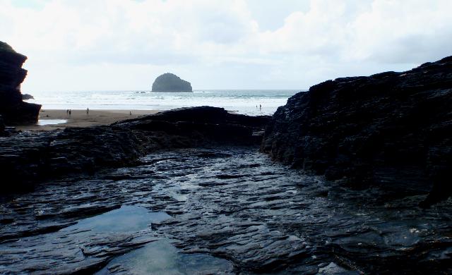
Trebarwith Strand is on the north coast of Cornwall. It is a fairly remote, sandy bay, approximately 800 metres wide, sheltered by high rocky cliffs with many caves and rock pools. There is a stream that flows across the beach into the sea.
-
Cornwall
-
Cornwall
-
Environment Agency investigations have shown that the impact on the Trebarwith Stream and the bathing water from Treknow sewage treatment works has been largely resolved by the addition of ultraviolet (UV) disinfection of the effluent. However, during periods of heavy rainfall the stream can still be contaminated.
-
There is an emergency/storm overflow from the Trebarwith Road pumping station, that discharges to the Trebarwith Stream 70m from the Environment Agency monitoring point. The operation of the overflow can lead to a temporary drop in water quality in the Trebarwith Stream and Trebarwith Strand bathing water.
-
The South West Water sewage treatment scheme for Treknow, which provides secondary treatment and UV disinfection, was completed in early 2007. Improvements to the storm overflow from Treknow sewage treatment works (STW) were also completed at that time. Storm overflow event duration monitoring (EDM) was installed at Treknow STW by December 2011.
-
There are no outfalls on the beach.
-
For the four year (2015-2018) assessment period where data is available, seaweed (macroalgae) was not assessed as being sufficient to be objectionable, but was observed as being present on 42% of visits. The bathing water can become covered with large amounts of seaweed, depending on tides and the weather. This bathing water does not have a history of large amounts of seaweed, but rocks, platforms or other fixed objects may develop a covering of seaweed which can be slippery.
-
For the four year (2015-2018) assessment period where data is available, phytoplankton (microscopic algae) was not noted at this site. Phytoplankton (microscopic algae) naturally increase in number at certain times of the year. This process is known as a phytoplankton bloom. This bathing water does not have a history of phytoplankton blooms. The risks to human health from contact, ingestion or inhalation with marine algae that currently occur in UK coastal waters are considered to be low. However, some individuals may be more sensitive and display some reactions. A common marine algae found in UK coastal waters is Phaeocystis, which is often mistaken for sewage as it forms foam and a brown scum, but it is non-toxic.
-
2019 Bathing Water Profile for Trebarwith Strand
-
2019-09-30
-
2019-05-01
-
Streams and rivers are typically affected by human sewage, animal slurry and runoff from roads. The Trebarwith Stream flows across this beach. The Environment Agency have monitored the stream since 1990 and found that water quality is temporarily worse after heavy rainfall.
-
The outfall from Treknow STW discharges to the Trebarwith Stream approximately 600m upstream of this bathing water. This discharge is disinfected and designed to protect bathing water quality.
-
Environment Agency samplers make observations of litter present on the beach at every visit, this includes assessments of sewage debris, litter and tar. At Trebarwith Strand for the four year (2015-2018) assessment period where data is available, sewage debris was not noted at this site. Litter was not assessed as being sufficient to be objectionable, but was observed as being present on 24% of visits. Tarry residue was not noted at this site.
-
There are five farms in the catchment, which are mostly dairy and beef. During and after periods of heavy rainfall, runoff to the Trebarwith Stream from agricultural land is greatly increased, and the quality of the bathing water can be reduced.
-
The catchment surrounding Trebarwith Strand is approximately 650 hectares. The Trebarwith Stream is approximately 4.3 kilometres (km) (seven kilometres long including tributaries). It flows from west to east through farmland, quarry land, and a steep wooded valley before entering the sea at Trebarwith Strand. The steep catchment means rain runs off rapidly into the stream. The coastal cliffs are about 100m high and are some of the tallest in Cornwall. Land use is agricultural, with five farms. The agricultural land is mostly improved grassland with some smaller arable areas. Mixed woodland areas can be found mostly in the valleys. The coastal section is designated as both a Site of Special Scientific Interest (SSSI) and Special Area of Conservation (SAC). The catchment is within the Cornwall Area of Outstanding Natural Beauty (AONB).
-
Trebarwith Strand
-
Trebarwith Strand
-
Sampling point at Trebarwith Strand
-
204850
-
50.64496675477914
-
-4.761636038784498
-
86450
-
Sampling point at Trebarwith Strand
-
-
-
p152 dT23 h59 m59 s
-
2019 05 01 t00:00:00
-
2019-05-01T00:00:00
-
-
2019 09 30 t23:59:59
-
2019-09-30T23:59:59
-
-
-
2019 33350:1
-
Seaweed (macroalgae) and phytoplankton (microscopic algae) are a natural part of the marine and freshwater environment. Below we note whether these have been recorded in quantities sufficient to be a nuisance.
-
The majority of sewers in England are “combined sewers” and carry both sewage and surface water from roofs and drains. A storm overflow operates during heavy rainfall when the sewerage system becomes overwhelmed by the amount of surface water. The overflow prevents sewage from backing up pipes and flooding properties and gardens. An emergency overflow will only operate infrequently, for example due to pump failure or blockage in the sewerage system.
-
Heavy rain falling on pavements and roads often flows into surface water drains or highway drains, ending up in local rivers and ultimately the sea. The quality of bathing water may be adversely affected as a result of such events.
-
It is the Environment Agency role to drive improvement of water quality at bathing waters that are at risk of failing higher standards. It is natural for water to run off the land to the sea. Water quality at a bathing water is dependent upon the type and area of land (the catchment) draining to the water and the activities undertaken in that catchment.
-
Discharges from sewage treatment works have improved substantially in England since the 1980s.
-
