2024 Bathing Water Profile for Crinnis Beach
-
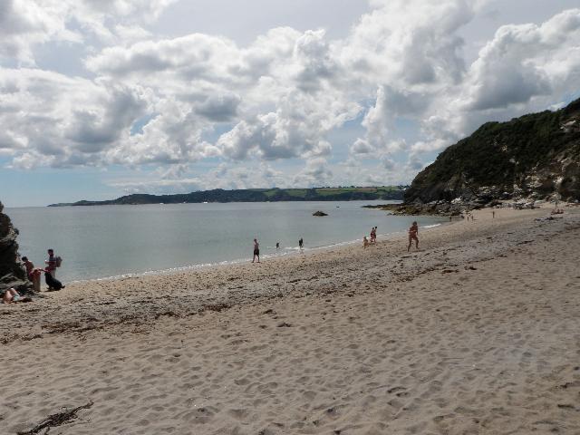
Crinnis beach is on the south coast of Cornwall. It is a sandy beach resort, approximately 760 metres wide, backed by sand dunes. Crinnis beach was previously named Crinnis Leisure Centre beach.
-
Cornwall
-
Cornwall
-
The need for sewage treatment around the northern part of St Austell Bay was identified to protect the bathing waters at Polkerris, Par, Shorthorn, Crinnis, Charlestown, Duporth and Porthpean. The South West Water sewage treatment scheme for Polkerris, which provides fine screening, was completed in 2003. A sewage treatment works (STW) for Par at Merthen Farm (north of Crinnis) was built by South West Water in 1992 and commissioned in 1993. The scheme included the collection of sewage from Par, Charlestown, Duporth, Porthpean and part of the St Austell catchment, and transfer via a tunnel sewer to Par STW where it receives secondary treatment before being discharged through a 1.3 kilometre (km) sea outfall south of Fishing Point in St Austell Bay. The scheme also included extensive resewerage and removal of various untreated discharges and a primary treated effluent discharge at Par Spit. The storm tank at Par STW and Harbour Road (No.2) pumping station storm overflow were improved by April 2006. The sewage treatment scheme for St Austell North (Luxulyan), which provides secondary treatment and ultraviolet (UV) disinfection, was completed in early 2006. Improvements to the storm discharge from St Austell North STW were also made at that time. Storm overflow event duration monitoring (EDM) was installed at Par and St Austell North STWs, and Par No.1 and 2 pumping stations by April 2011.
-
For the four year (2020-2023) assessment period where data is available, seaweed (macroalgae) was assessed as being sufficient to be objectionable for 11% of visits, with 64% of visits noting the presence of seaweed (macroalgae). This bathing water does not have a history of large amounts of seaweed (macro algae).
-
For the four year (2020-2023) assessment period where data is available, phytoplankton (microscopic algae) was not noted at this site. Phytoplankton (microscopic algae) naturally increase in number at certain times of the year. This process is known as a phytoplankton bloom. This bathing water does not have a history of phytoplankton blooms. The risks to human health from contact, ingestion or inhalation with marine algae that currently occur in UK coastal waters are considered to be low. However, some individuals may be more sensitive and display some reactions. A common marine algae found in UK coastal waters is Phaeocystis, which is often mistaken for sewage as it forms foam and a brown scum, but it is non-toxic.
-
This bathing water is subject to short term pollution procedures. The Environment Agency makes a daily pollution risk forecast at this site based on the effects of rain, wind and seasonality on bathing water quality. These factors affect the levels of bacteria that get washed into the sea from livestock, sewage and urban drainage via rivers and streams and how they disperse. When these factors combine to make short term pollution likely we issue a pollution risk warning on this website and the beach manager will display a sign advising against bathing at the bathing water. After a short term pollution event, levels of bacteria typically return to normal after a day or so but it's possible to have several warning days in a row. Details of the work to reduce the sources of bacteria at this bathing water are detailed in this profile. In 2023 no pollution risk warnings were issued for this bathing water. All bathing waters have the potential to be affected by a pollution incident and if this occurs a pollution risk warning will be issued with associated advice against bathing on this website.
-
2024 Bathing Water Profile for Crinnis Beach
-
2024-09-30
-
2024-05-01
-
The outfall from Par STW discharges to the sea approximately 1.6km southeast of this bathing water. This discharge is designed to protect bathing water quality.
-
Environment Agency samplers make observations of litter present on the beach at every visit, this includes assessments of sewage debris, litter and tar. At Crinnis Beach for the four year (2020-2023) assessment period where data is available, sewage debris was not noted at this site. Litter was not assessed as being sufficient to be objectionable, but was observed as being present on 54% of visits. Tarry residue was not noted at this site.
-
The catchment surrounding Crinnis Beach is approximately 1,400 hectares. There are no streams flowing onto the beach. The immediate catchment is small (13.5 hectares), and surface water flows down the south facing slopes to the sea. There is a small stream flowing west to east behind the beach which takes some of the surface water to the next beach. The water quality at the beach can also be affected by the Crinnis Stream which enters the sea at Shorthorn Beach. The Crinnis Stream collects water from two main tributaries. One tributary is approximately five kilometres (km) long and starts at St Austell. The other tributary is approximately four and a half kilometres long and rises northwest of St Blazey. The streams are channelled underground in many places, especially where they flow through St Austell and Carlyon Bay. Land use is split between agricultural land and urban/mining land. Urban areas include St Austell, Carlyon Bay and part of St Blazey. The Eden Project is in the northeast of the catchment. There are two geological Sites of Special Scientific Interest (SSSI's) associated with the mining activity.
-
Crinnis Beach
-
Crinnis Beach
-
Sampling point at Crinnis Beach
-
205550
-
50.33609981662796
-
-4.733841447922212
-
52040
-
Sampling point at Crinnis Beach
-
-
-
p152 dT23 h59 m59 s
-
2024 05 01 t00:00:00
-
2024-05-01T00:00:00
-
-
2024 09 30 t23:59:59
-
2024-09-30T23:59:59
-
-
-
2024 27500:1
-
Seaweed (macroalgae) and phytoplankton (microscopic algae) are a natural part of the marine and freshwater environment. Below we note whether these have been recorded in quantities sufficient to be a nuisance.
-
The majority of sewers in England are “combined sewers” and carry both sewage and surface water from roofs and drains. A storm overflow operates during heavy rainfall when the sewerage system becomes overwhelmed by the amount of surface water. The overflow prevents sewage from backing up pipes and flooding properties and gardens. An emergency overflow will only operate infrequently, for example due to pump failure or blockage in the sewerage system.
-
Heavy rain falling on pavements and roads often flows into surface water drains or highway drains, ending up in local rivers and ultimately the sea. The quality of bathing water may be adversely affected as a result of such events.
-
It is the Environment Agency role to drive improvement of water quality at bathing waters that are at risk of failing higher standards. It is natural for water to run off the land to the sea. Water quality at a bathing water is dependent upon the type and area of land (the catchment) draining to the water and the activities undertaken in that catchment.
-
Discharges from sewage treatment works have improved substantially in England since the 1980s.
-
