2024 Bathing Water Profile for Salcombe South Sands
-
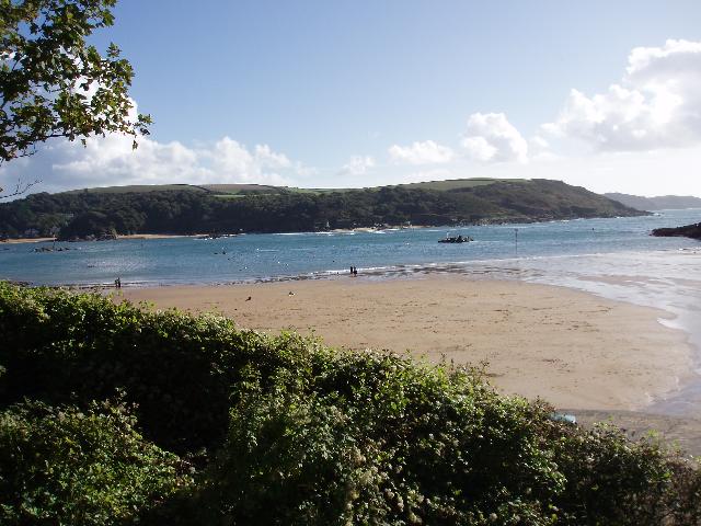
Salcombe South Sands is on the south coast of Devon on the East bank of the Kingsbridge Estuary. It is a sandy beach resort, approximately 180 metres wide, backed by cliffs. A stream flows across the beach to the sea.
-
South Hams District
-
Devon
-
The Environment Agency periodically carries out additional catchment monitoring, and this is used to make recommendations for further improvements to protect and improve bathing water quality.
-
There is an emergency/storm overflow from the Malborough STW that discharges to the Salcombe Estuary 430m from the beach. There is an emergency/storm overflow from the South Sands pumping station that discharges to the Combe Stream 50m from the beach. The operation of the overflows can lead to a temporary drop in bathing water quality. This bathing water is included in the Surfers Against Sewage “Safer Seas Service”. This service can alert you to Combined Storm Sewer Overflow discharges via a phone App and in addition, it includes the Environment Agency Pollution Risk Forecast warnings where they are available. Further details of the service can be found at - http://www.sas.org.uk/safer-seas-service/
-
The South West Water sewage treatment scheme for Salcombe, which provides secondary treatment and ultraviolet (UV) disinfection, was completed in 1996. The scheme included some resewerage and improvement to combined sewer overflows (CSO). The South West Water sewage treatment scheme for East Portlemouth, which provides secondary treatment at Ditch End sewage treatment works (STW), was completed in April 1999. Repairs to the outfall at Ditch End were completed in Summer 2000. Flows from Mill Bay are pumped to Ditch End STW for treatment, and the outfall at Mill Bay has been retained as surface water outfall. Gerston STW was improved by April 2003. The following discharges into the Salcombe Kingsbridge Estuary have also been improved to protect shellfish waters: West Charleton STW and CSO (October 2004), Frogmore and Chillington STW (November 2005), Chillington SSO (April 2004), Sherford STW and SO (March 2018)and CSO's at Bridge Street, Marlborough, Prince of Wales Road, Tacket Wood SPS (July 2005), West Alvington (October 2005) and Chillington ( March 2018). Storm overflow event duration monitoring (EDM) was installed at Quillets CSO, South Sands CSO, and Malborough Village pumping station by May 2011. Improvements to Salcombe Malborough STW EO are scheduled for completion by March 2025. South West Water are currently improving the sewer network higher in the catchment and are also investigating and carrying out remedial works where saline water may enter the sewer system.
-
The urban area of Salcombe immediately behind the beach is served by a combined (surface and sewer) system. There are no outfalls from the system onto the beach.
-
For the four year (2020-2023) assessment period where data is available, seaweed (macroalgae) was assessed as being sufficient to be objectionable for 13% of visits, with 84% of visits noting the presence of seaweed (macroalgae). The bathing water can become covered with large amounts of seaweed at certain times of the year, depending on tides and the weather. Groynes and rocks, platforms or other fixed objects may also develop a covering of seaweed which can be slippery.
-
For the four year (2020-2023) assessment period where data is available, phytoplankton (microscopic algae) was not noted at this site. Phytoplankton (microscopic algae) naturally increase in number at certain times of the year. This process is known as a phytoplankton bloom. These blooms can discolour the water or form as a foam on the water. This bathing water does not have a history of phytoplankton blooms. The risks to human health from contact, ingestion or inhalation with marine algae that currently occur in UK coastal waters are considered to be low. However, some individuals may be more sensitive and display some reactions. A common marine algae found in UK coastal waters is Phaeocystis, which is often mistaken for sewage as it forms foam and a brown scum, but it is non-toxic.
-
The Environment Agency makes a daily pollution risk forecast at this site based on the effects of rain and wind on bathing water quality. These factors affect the levels of bacteria that get washed into the sea from livestock, sewage and urban drainage via rivers and streams and how they disperse. When these factors combine to cause a temporary reduction in water quality, we will issue a pollution risk warning on this website. Water quality will typically return to normal after a day or so, but it’s possible to have several warning days in a row. Details of the work to reduce the sources of bacteria at this bathing water are detailed in this profile. In 2023 4 pollution risk warnings were issued for this bathing water. All bathing waters have the potential to be affected by a pollution incident and if this occurs a pollution risk warning will be issued with associated advice against bathing on this website.
-
2024 Bathing Water Profile for Salcombe South Sands
-
2024-09-30
-
2024-05-01
-
The Combe Stream flows across the beach to the south of the Environment Agency monitoring point. The Environment Agency have monitored the stream between 1987 and 2010, and found that it is typically affected by sewage from further up the catchment.
-
The Malborough STW outfall discharges to the Salcombe Estuary 430m from the beach . This discharge is disinfected and designed to protect bathing water quality.
-
Environment Agency samplers make observations of litter present on the beach at every visit, this includes assessments of sewage debris, litter and tar. At Salcombe South Sands for the four year (2020-2023) assessment period where data is available, sewage debris was not noted at this site. Litter was not assessed as being sufficient to be objectionable, but was observed as being present on 32% of visits. Tarry residue was not noted at this site.
-
In 2015 the Environment Agency worked with hotel owners to remove Illegal sewer overflow discharge within the catchment.
-
The catchment surrounding Salcombe South Sands is approximately 8,800 hectares. The Combe Stream is approximately two and a half kilometres long and descends to the Salcombe Kingsbridge Estuary at the beach from the village of Malborough. The estuary is unusual because it has no large river feeding it, just a series of small streams rising from springs at Frogmore, Bowcombe, Batson, East Allington, Sherford and other surrounding villages. The estuary is tidal to Kingsbridge, and like the other estuaries of South Devon, the original deep river valley has been flooded by sea level rise, to create a wide expanse of water with secluded creeks and side arms. Woodland fringes come down to the high tide line, and the areas of saltmarsh or grazing marsh are quite restricted. Kingsbridge and Salcombe are the main urban areas and land use is rural. Land use in the local area surrounding the bathing water is a combination of urban and rural, with just one or two farms.
-
Salcombe South Sands
-
Salcombe South Sands
-
Sampling point at Salcombe South Sands
-
272850
-
50.22603027118593
-
-3.783918780827058
-
37750
-
Sampling point at Salcombe South Sands
-
-
-
p152 dT23 h59 m59 s
-
2024 05 01 t00:00:00
-
2024-05-01T00:00:00
-
-
2024 09 30 t23:59:59
-
2024-09-30T23:59:59
-
-
-
2024 25300:1
-
Seaweed (macroalgae) and phytoplankton (microscopic algae) are a natural part of the marine and freshwater environment. Below we note whether these have been recorded in quantities sufficient to be a nuisance.
-
The majority of sewers in England are “combined sewers” and carry both sewage and surface water from roofs and drains. A storm overflow operates during heavy rainfall when the sewerage system becomes overwhelmed by the amount of surface water. The overflow prevents sewage from backing up pipes and flooding properties and gardens. An emergency overflow will only operate infrequently, for example due to pump failure or blockage in the sewerage system.
-
Heavy rain falling on pavements and roads often flows into surface water drains or highway drains, ending up in local rivers and ultimately the sea. The quality of bathing water may be adversely affected as a result of such events.
-
It is the Environment Agency role to drive improvement of water quality at bathing waters that are at risk of failing higher standards. It is natural for water to run off the land to the sea. Water quality at a bathing water is dependent upon the type and area of land (the catchment) draining to the water and the activities undertaken in that catchment.
-
Discharges from sewage treatment works have improved substantially in England since the 1980s.
-
