2014 Bathing Water Profile for Traeth Lligwy
-
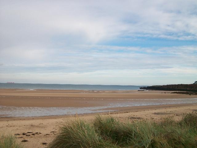
Situated on the east coast of Anglesey, to the north of the village of Moelfre, the beach measures just over 1 kilometre at its widest point. It is a relatively sheltered sandy beach, surrounded by limestone rocks and agricultural land. Traeth Lligwy is located in the Anglesey Area of Outstanding Natural Beauty, with sections of the beach designated as the Lligwy Special Site of Scientific Interest. The water quality sample point is located at the centre of the bay.
-
Isle of Anglesey
-
Natural Resources Wales works to establish sources of pollution around Traeth Lligwy. Some of this work is carried out in partnership with Anglesey County Council and Dŵr Cymru Welsh Water. Inspections are carried out by Natural Resources Wales in partnership with the local authority and the water company. These are carried out pre-season (before the 1st of May) and mid season if required (during the bathing water season). Bacterial surveys of the streams draining to the beach have historically been carried out, and followed up with pollution prevention visits to the caravan sites in the area to check on their septic tanks.
-
There are no storm discharges in the catchment.
-
There are no water company assets in the Traeth Lligwy catchment. Sewage effluent from Moelfre is pumped south, to the treatment works at Benllech.
-
Natural Resources Wales continues to work with Anglesey Council, to maintain the high standard of water quality at Traeth Lligwy.
-
This bathing water does not have a history of large amounts of seaweed (macroalgae).
-
There are no known misconnections in the catchment. Modern sewerage systems have two separate systems, one takes foul sewage to sewage treatment, the other takes rainwater runoff through surface water drains to rivers, lakes and the sea. Misconnections occur when waste water pipes are plumbed into surface water drains instead of the foul water sewerage system. This can give rise to pollution when the waste water is discharged directly to the environment through the surface water drain. For example, a washing machine or toilet may be incorrectly plumbed so that it discharges to the surface drain rather than the foul sewage drain.
-
Phytoplankton (microscopic algae) naturally increase in number at certain times of the year. This process is known as a phytoplankton bloom. Algal Blooms can occur at any beach during the bathing season and are usually noticeable by a surface scum. This beach has no history of such blooms.
-
2014 Bathing Water Profile for Traeth Lligwy
-
Streams are typically affected by sewage or industrial run off from further up the catchment. The River Lligwy and the Nant Perfedd drain down through the catchment, directly onto the beach, discharging in the middle of the designated bathing area. There may be reduced water quality in the adjacent area, where the stream enters the beach and the sea.
-
The catchment of the Traeth Lligwy bathing water, is largely agricultural with significant areas of land occupied by livestock. There are currently no known issues with the farms in this catchment that could adversely affect the current bathing water quality.
-
There are a number of caravan sites in the area. The majority have been identified as having private sewage disposal systems. The camp site nearest to the beach discharges to ground. Consequently, it is not perceived as presenting a risk to surface water by draining onto the beach. If any concerns arise, Natural Resources Wales will investigate and request immediate remedial action from those responsible. At present, there are no private domestic owners in the area with the potential to impact bathing water quality at Traeth Lligwy. Poorly maintained private sewage treatment facilities could be a source of pollution, therefore the registration of all private sewage systems in Wales is required by 30 June 2012. The primary aim of this exercise is to provide increased protection for the environment and sensitive features such as bathing water beaches. Where properties are identified in the catchment that are not on mains sewerage, Natural Resources Wales will endeavour to ensure registration has been made.
-
The natural drainage (hydrological) catchment surrounding the bathing water is primarily rural. Agricultural land use, mainly pasture, predominates, with a number of caravan sites and isolated dwellings scattered throughout the upper catchment.
-
2014 40085:1
-
Seaweed (macroalgae) and phytoplankton (microscopic algae) are a natural part of the marine and freshwater environment. Below we note whether these have been recorded in quantities sufficient to be a nuisance.
-
The majority of sewers in England and Wales are “combined sewers” and carry both sewage and surface water from roofs and drains. A storm overflow operates during heavy rainfall when the sewerage system becomes overwhelmed by the amount of surface water. The overflow prevents sewage from backing up pipes and flooding properties and gardens. An emergency overflow will only operate infrequently, for example due to pump failure or blockage in the sewerage system.
-
Heavy rain falling on pavements and roads often flows into surface water drains or highway drains, ending up in local rivers and, ultimately, the sea. The quality of bathing water may be adversely affected as a result of such events.
-
It is the Environment Agency and Natural Resources Wales role to drive improvement of water quality at bathing waters that are at risk of failing European standards. It is natural for water to run off the land to the sea. Water quality at a bathing water is dependent upon the type and area of land (the catchment) draining to the water and the activities undertaken in that catchment.
-
Discharges from sewage treatment works have improved substantially in England and Wales since the 1980s.
-
