2014 Bathing Water Profile for Llandudno West Shore
-
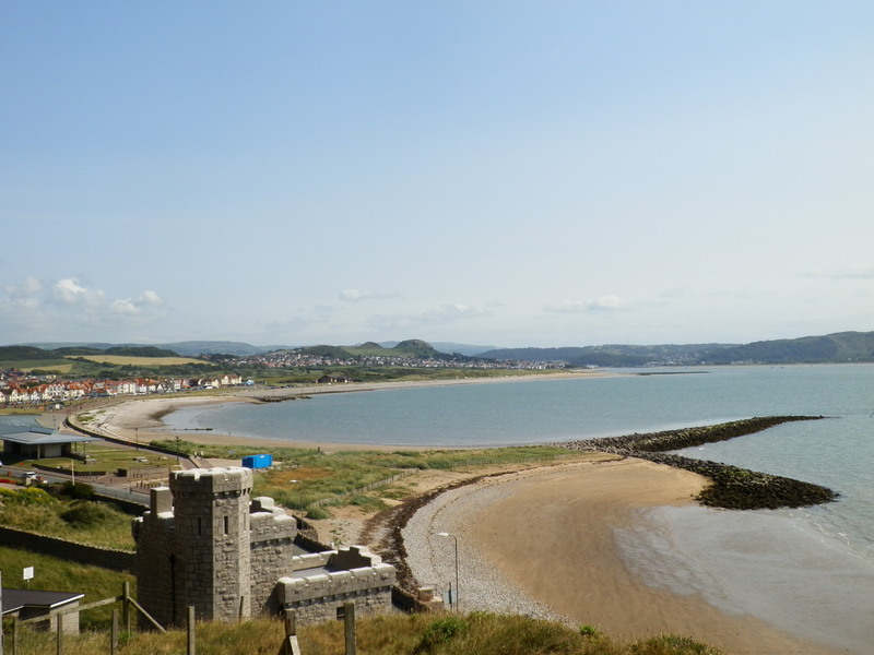
Situated on the north Wales coastline, below the Great Orme, the bay faces west over Conwy Sands. The beach is long and sandy with a stony pebble foreshore, backed by a concrete promenade. The sea area offshore is designated under the Menai Strait and Conwy Special Area of Conservation, whilst the Great Orme is designated as the Great Orme’s Head Special Area of Conservation. The bathing water also lies in the Aber Afon Conwy Site of Special Scientific Interest. The water quality sample point is located in-line with the north of the paddling pool.
-
Conwy
-
Natural Resources Wales works to establish sources of pollution around Llandudno West Shore. Some of this work is carried out in partnership with Conwy County Council and Dŵr Cymru Welsh Water. Inspections are carried out by Natural Resources Wales in partnership with the local authority and the water company. These are carried out pre-season (before the 1st of May) and mid season, if required (during the bathing water season). Natural Resources Wales has undertaken investigations into the impact of the intermittent storm discharges that drain into the Conwy estuary. Dwr Cymru Welsh Water have committed to repairing the long sea outfall before the start of the bathing water season in 2013. Telemetry and pump problem was found at Rhoslan pumping station near the EC bathing water point. Dwr Cymru Welsh Water have fixed the issues and are going to investigate over the next 3 years how much surface water they can remove from the foul sewer to reduce discharge frequency and spillage at this site. Natural Resources Wales will keep a watching brief on the situation Monitoring work since 2008, undertaken as part of the Conwy Shellfish Project, has demonstrated that there has been a bacterial impact on the main River Conwy. Pollution prevention work carried out as a result of the monitoring continues to help to improve the bathing water quality.
-
The Conwy estuary and West Shore bathing waters are potentially impacted by a number of storm and emergency overflows, both along the immediate foreshore and within the main freshwater from the Conwy. The storm sewage from the Ganol Wastewater Treatment Works, further up the Conwy is disinfected before being discharged into the Conwy estuary. The scheme is designed to comply with the requirements of the Shellfish Waters Directive and has strict rules regarding storage and the number of spills allowed. The numerous storm overflows protect the relatively low-lying land of Llandudno, Deganwy and Llandudno Junction from being flooded by sewage during heavy rainfall. However, sewer overflows operating during and following periods of heavy rainfall can result in reduced water quality in the Conwy and at the bathing water.
-
Natural Resources Wales has developed a good working relationship with Dŵr Cymru Welsh Water and liaises regularly to identify problems that could affect bathing water quality. A major improvement scheme was completed by Dŵr Cymru Welsh Water for Conwy, Deganwy, Llandudno and Colwyn Bay, in 1999. The sewage from the immediate catchment of Llandudno and the aforementioned areas is now pumped to the Ganol Wastewater Treatment Works at Llandudno Junction. The wastewater treatment works discharges disinfected secondary treated effluent through a sea outfall, to the east of Llandudno into Penrhyn Bay. Previous to this work, Dŵr Cymru Welsh Water had constructed a long sea outfall at West Shore, to direct sewage away from the bathing area. Associated investigations have identified misconnections and/or leaking sewers. Subsequent remedial works have been carried out and further improvements are planned. During the 2012 bathing season, Dŵr Cymru Welsh Water will be replacing the long sea outfall at West Shore.
-
Natural Resources Wales continues to work together with Conwy Council to maintain the high standard of water quality at Llandudno West Shore. Previous to the improvement scheme, Dŵr Cymru Welsh Water had constructed a long sea outfall at the West Shore in order to take the sewage away from the shore area. This is being replaced in 2012.
-
This bathing water does not have a history of large amounts of seaweed (macroalgae).
-
Modern sewerage systems have two separate systems, one takes foul sewage to sewage treatment, the other takes rainwater runoff through surface water drains to rivers, lakes and the sea. Misconnections occur when waste water pipes are plumbed into surface water drains instead of the foul water sewerage system. This can give rise to pollution when the waste water is discharged directly to the environment through the surface water drain. For example, a washing machine or toilet may be incorrectly plumbed so that it discharges to the surface drain rather than the foul sewage drain.
-
Phytoplankton (microscopic algae) naturally increase in number at certain times of the year. This process is known as a phytoplankton bloom. Algal Blooms can occur at any beach during the bathing season and are usually noticeable by a surface scum. This beach has no history of such blooms.
-
2014 Bathing Water Profile for Llandudno West Shore
-
Streams are typically affected by sewage or industrial run off from further up the catchment. Llandudno West Shore bathing water is situated on the Conwy estuary at the bottom of the River Conwy. The Creuddyn does not drain onto the bathing beach, but is diverted through a sea outfall pipe.
-
The Conwy estuary drains a catchment dominated by agriculture and forestry. During and after periods of heavy rainfall, runoff from agricultural areas will be greatly increased. A considerable amount of pollution prevention work has been carried out historically with the farms in the catchment to reduce the bacterial load on the river.
-
The Tre Marl Industrial estate at Llandudno Junction is mainly made up of light industrial units. A pollution prevention day was held by Natural Resources Wales, concentrating on potential discharges to a ditch, which then flows into the Conwy. There are several consented treated sewage discharges into this ditch (the Jackson stream).
-
Natural Resources Wales continues to work with private owners to address potential pollution sources to the bathing water. This work involves where necessary, advisory mail drops, dye tracing, misconnection surveys and face to face meetings. There are a number of private properties on the Great Orme which are not on the main sewage system and have private sewage treatment arrangements. Pollution prevention visits have been undertaken to provide advice on appropriate management and maintenance of these systems. Poorly maintained private sewage treatment facilities could be a source of pollution, therefore the registration of all private sewage systems in Wales is required by 30 June 2012. The primary aim of this exercise is to provide increased protection for the environment and sensitive features such as bathing water beaches. Where properties are identified in the catchment that are not on mains sewerage, Natural Resources Wales will endeavour to ensure registration has been made.
-
The natural drainage (hydrological) catchment surrounding the bathing water is primarily urban, namely the town of Llandudno, and the limestone outcrop of the Great Orme. The beach lies on the Conwy estuary at the bottom of the Conwy valley. The Conwy Valley extends approximately 25 kilometres inland to Betws-y-Coed, before the main river is joined by a number of key tributaries, e.g. the Lledr, the Machno and the Merddwr. In the lower section below Llanrwst, the Roe and Hiraethlyn are two of the main tributaries, draining agricultural catchments dominated by managed grassland and forestry. The main valley is also dominated by managed grassland and sheep farming, with a number of settlements e.g. Trefriw and Dolgarrog. These are connected to the foul sewer. The valley sides rise more sharply in the middle section of the valley, near Llanrwst, particularly on the west side. Discharges from historic metal mines on the western side impact upon the local rivers. Forestry predominates as the main land use along with some rough grazing. The more upper areas of the catchment beyond Betws-y-Coed are mainly grassland and sheep farming.
-
2014 40200:1
-
Seaweed (macroalgae) and phytoplankton (microscopic algae) are a natural part of the marine and freshwater environment. Below we note whether these have been recorded in quantities sufficient to be a nuisance.
-
The majority of sewers in England and Wales are “combined sewers” and carry both sewage and surface water from roofs and drains. A storm overflow operates during heavy rainfall when the sewerage system becomes overwhelmed by the amount of surface water. The overflow prevents sewage from backing up pipes and flooding properties and gardens. An emergency overflow will only operate infrequently, for example due to pump failure or blockage in the sewerage system.
-
Heavy rain falling on pavements and roads often flows into surface water drains or highway drains, ending up in local rivers and, ultimately, the sea. The quality of bathing water may be adversely affected as a result of such events.
-
It is the Environment Agency and Natural Resources Wales role to drive improvement of water quality at bathing waters that are at risk of failing European standards. It is natural for water to run off the land to the sea. Water quality at a bathing water is dependent upon the type and area of land (the catchment) draining to the water and the activities undertaken in that catchment.
-
Discharges from sewage treatment works have improved substantially in England and Wales since the 1980s.
-
