2014 Bathing Water Profile for Rhossili
-
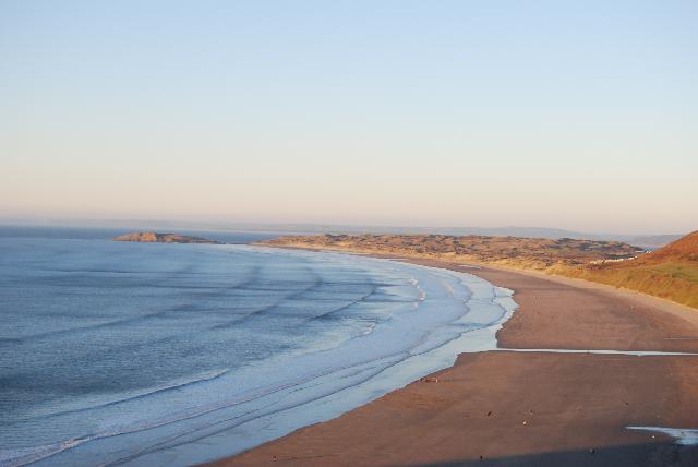
The beach, located on the most western point on the Gower Peninsular, is part of a wide expanse of sand, stretching 3 kilometres from Burry Holmes, to Worms Head. The gently sloping bay faces west out into the Atlantic and is backed by steep limestone cliffs on the south side, Rhossili Downs on the east, with sand dunes and moors in the north. The water quality sample point is located directly in line with the camp site. The beach is better known as Llangennith Beach.
-
Swansea
-
Natural Resources Wales works to establish sources of pollution around Rhossili. Some of this work is carried out in partnership with the City and County of Swansea and Dŵr Cymru Welsh Water. Inspections are carried out by Natural Resources Wales in partnership with the local authority and the water company. These are carried out pre-season (before the 1st of May) and mid-season, if required (during the bathing water season).
-
Hillend Pumping Station has a storm overflow, which sometimes operates during very heavy rainfall. This protects domestic properties in Llangennith from being flooded by sewage during heavy rainfall. The outfall is approximately 1 kilometre from the bathing water, to a stream which flows onto the beach. This has not been associated with any bathing water sample failures.
-
This bathing water does not have a history of large amounts of seaweed (macroalgae).
-
Modern sewerage systems have two separate systems, one takes foul sewage to sewage treatment, the other takes rainwater runoff through surface water drains to rivers, lakes and the sea. Misconnections occur when waste water pipes are plumbed into surface water drains instead of the foul water sewerage system. This can give rise to pollution when the waste water is discharged directly to the environment through the surface water drain. For example, a washing machine or toilet may be incorrectly plumbed so that it discharges to the surface drain rather than the foul sewage drain.
-
Phytoplankton (microscopic algae) naturally increase in number at certain times of the year. This process is known as a phytoplankton bloom. These algal blooms can occur at any beach during the bathing season and are usually noticeable by a surface scum. This beach has a history of such blooms.
-
2014 Bathing Water Profile for Rhossili
-
A slow flowing stream runs on to the beach 300 metres north of the sample point, known as Diles Lake. This stream is the most significant watercourse in the catchment and drains an agricultural area. The storm overflow outfall from Hillend Pumping Station discharges into this stream. The Loughor Estuary has the potential to affect water quality in Rhossili Bay under certain conditions. Vegetation and animal droppings are often seen on the beach after high spring tides. It is likely that they originate from the grazed salt marshes.
-
There are no sewage treatment works outfalls that discharge directly onto the beach. The nearest treatment works outfall is from the Rhossili Sewage Treatment Works at Pitton, the outfall from which is to coastal waters below Ram Grove. This is located approximately 6 kilometres, roughly south-east, along the coast from the bathing water monitoring point towards Swansea.
-
Poorly maintained private sewage treatment facilities could be a source of pollution, therefore the registration of all qualifying private sewage systems in Wales was required by 30 June 2012. The primary aim of this exercise is to provide increased protection for the environment and sensitive features such as bathing water beaches. Where discharges from properties are identified in the catchment that are not on mains sewerage, Natural Resources Wales will endeavour to ensure registration has been made, unless already a permitted discharge.
-
The natural drainage (hydrological) catchment of Rhossili Bay changes from vertical sea cliffs in the south to low lying moorland and sand dunes near to the beach area. From the beach, the land climbs gently towards the village of Llangennith and the top of the catchment, approximately 2 kilometres away. A slow flowing stream runs on to the beach, 300 metres north of the sample point. There is a caravan and camping site just behind the beach car park. The majority of the land use in the area is sheep, cattle and horse grazing. The Loughor Estuary, which has a substantial natural drainage catchment, is just around the corner to the north of Rhossili Bay. The catchment is predominantly agricultural and the salt marshes are heavily grazed by sheep, horses and cattle.
-
2014 37600:1
-
Seaweed (macroalgae) and phytoplankton (microscopic algae) are a natural part of the marine and freshwater environment. Below we note whether these have been recorded in quantities sufficient to be a nuisance.
-
The majority of sewers in England and Wales are “combined sewers” and carry both sewage and surface water from roofs and drains. A storm overflow operates during heavy rainfall when the sewerage system becomes overwhelmed by the amount of surface water. The overflow prevents sewage from backing up pipes and flooding properties and gardens. An emergency overflow will only operate infrequently, for example due to pump failure or blockage in the sewerage system.
-
Heavy rain falling on pavements and roads often flows into surface water drains or highway drains, ending up in local rivers and, ultimately, the sea. The quality of bathing water may be adversely affected as a result of such events.
-
It is the Environment Agency and Natural Resources Wales role to drive improvement of water quality at bathing waters that are at risk of failing European standards. It is natural for water to run off the land to the sea. Water quality at a bathing water is dependent upon the type and area of land (the catchment) draining to the water and the activities undertaken in that catchment.
-
Discharges from sewage treatment works have improved substantially in England and Wales since the 1980s.
-
