Dunes
Defence
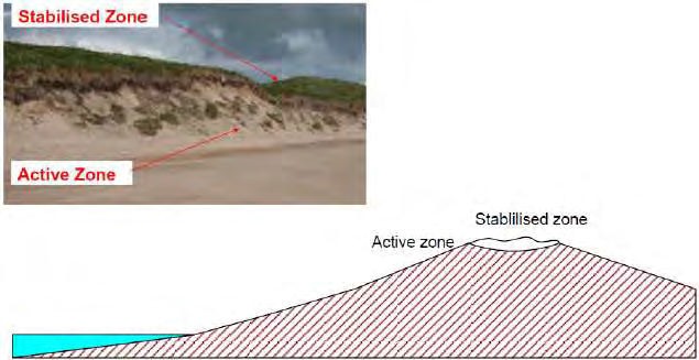
Dunes that are found along the coast can provide a flood defence and/or erosion protection function.
The stabilised zone is a combination of slacks, dune ridges, and dune pastures, which not only protect the hinterland from flooding but are multi functional for ecology and recreational purposes. A wide dune system might be compromised by flow routes through the slack.
Dunes are displayed in AIMS as a polyline showing the line of centre the defence.

Elements
An Element Type is a component part of an Asset Type. Each Asset Type (except Asset Complex assets) will comprise of a prescribed set of Element Types. Some Element Types are essential and must be present to define an asset of that Asset Type. Other Element Types are optional, to be included when needed to define a particular Asset Type instance. An individual asset may have more than one instance of each Element Type.
This table lists the Element Types applicable to this Asset Type.
| Element Type | Description | Element Code | Essential | Uniclass 2015 | Updates |
|---|---|---|---|---|---|
| Active Zone | The section of a dune that can be easily eroded and therefore liable to rapid change | ACZ | Yes | 25-02-2020 | |
| Stabilised Zone | The section of a dune that has been consolidated by management or natural vegetation and therefore more resistant to erosion than the active zone | SZE | No | 25-02-2020 |
Attributes
An attribute is a particular piece of data that describes a property of an object. Each Asset Type is described by a different set of attributes, although there are some attributes that are common to many Asset Types.
The table below lists the attributes that are applicable to this Asset Type, along with the data profile requirements for each attribute and details of when and how each should be used and delivered.
| Attribute | Format Details | Delivery | Purpose | Mandatory | geoCOBie Mapping | Updates |
|---|---|---|---|---|---|---|
| (Inspection) Data Quality The inspection data quality | Picklist 1 2 3 4 5 | EA7 | Feature.Attribute.Name.InspectionDataQuality | 05-05-2020 | ||
| Actual DCL The real, measured crest level: at the downstream extent of a fluvial/tidal linear defence asset or at the rightmost extent of a coastal linear defence asset | Number Max: 300.000 Number of decimal places: 3 Can be negative? false Units: mAOD | EA7 | Feature.Attribute.Name.ActualDcl | 05-05-2020 | ||
| actual DCL date The date the actual downstream crest level was taken | Date | EA7 | Feature.Attribute.Name.ActualDclDate | 25-02-2020 | ||
| Actual DCL DQF The data quality flag for the actual downstream crest level | Picklist 1 2 3 4 | EA7 | Feature.Attribute.Name.ActualDclDqf | 05-05-2020 | ||
| Actual DCL DQF Date The date the data quality flag for the actual downstream crest level was assessed | Date | EA7 | Feature.Attribute.Name.ActualDclDqfDate | 01-04-2020 | ||
| Actual UCL The real, measured crest level: at the upstream extent of a fluvial/tidal linear defence asset or at the leftmost extent of a coastal linear defence asset | Number Max: 300.000 Number of decimal places: 3 Can be negative? false Units: mAOD | EA7 | Feature.Attribute.Name.ActualUcl | 05-05-2020 | ||
| actual UCL date The date the actual upstream crest level was taken | Date | EA7 | Feature.Attribute.Name.ActualUclDate | 25-02-2020 | ||
| Actual UCL DQF The data quality flag for the actual upstream crest level | Picklist 1 2 3 4 | EA7 | Feature.Attribute.Name.ActualUclDqf | 05-05-2020 | ||
| Actual UCL DQF Date The date the data quality flag for the actual upstream crest level was assessed | Date | EA7 | Feature.Attribute.Name.ActualUclDqfDate | 01-04-2020 | ||
| alt asset ref The alternative asset reference used to cross reference to other data systems | Text Max Length: 30 | EA6 | Feature.Attribute.Name.AltAssetRef | 25-02-2020 | ||
| Asbestos on site Site is on the Asbestos Register? | Picklist Yes No | EA7 | Feature.Attribute.Name.AsbestosOnSite | 01-04-2020 | ||
| assessment reason The reason for carrying out the assessment | Picklist Scheduled Inspection Adhoc Inspection Post Incident Inspection Post Remedial Work Assessment | EA7 | Feature.Attribute.Name.AssessmentReason | 25-02-2020 | ||
| assessment reason text Any other comments about the reason for carrying out the assessment | Text Max Length: 200 | EA7 | Feature.Attribute.Name.AssessmentReasonText | 25-02-2020 | ||
| Asset ID System generated unique ID used as a primary key | Number Max: 9,999,999,999 Number of decimal places: 0 Can be negative? false | EA4 | Feature.Attribute.Name.AssetId | 04-04-2020 | ||
| asset maintainer The organisation or individual recognised to be the maintainer of the asset | Picklist Environment Agency Local Authority Internal Drainage Board Private Unknown | EA7 | Feature.Attribute.Name.AssetMaintainer | 25-02-2020 | ||
| Asset Name The name of the asset if it has one | Text Max Length: 150 | EA3 | Feature.Attribute.Name.AssetName | 05-05-2020 | ||
| asset operator The organisation or individual recognised to be the operator of the asset | Picklist Environment Agency Local Authority Internal Drainage Board Private Unknown | EA7 | Feature.Attribute.Name.AssetOperator | 25-02-2020 | ||
| asset owner The organisation or individual known to be the owner of the asset | Picklist Environment Agency Local Authority Internal Drainage Board Private Unknown | EA7 | Feature.Attribute.Name.AssetOwner | 25-02-2020 | ||
| Asset Ref Unique asset reference code in scheme context assigned by scheme designer eg DD0123 | Text Subtype code DD + sequence number | EA2 | Feature.Name.AssetRef | 25-02-2020 | ||
| asset start date The date the asset becomes operational | Date | EA6 | Feature.Attribute.Name.AssetStartDate | 25-02-2020 | ||
| Asset Subtype The subtype of asset | Picklist Dunes | EA3 | Feature.Attribute.Name.AssetSubtype | 05-05-2020 | ||
| Asset Type The type of asset | Picklist Defence | EA3 | Feature.Attribute.Name.AssetType | 05-05-2020 | ||
| bank The bank that the asset is on when looking downstream for fluvial assets. For coastal assets use coastal | Picklist left right coastal | EA7 | Feature.Attribute.Name.Bank | 25-02-2020 | ||
| calculated condition The condition of the asset calculated from the element weightings and conditions configuration | Picklist 1 2 3 4 5 | EA7 | Feature.Attribute.Name.CalculatedCondition | 25-02-2020 | ||
| comments Other comments about the asset | Text Max Length: 2000 | EA3 | Feature.Attribute.Name.Comments | 25-02-2020 | ||
| Crest Levels (locatable attribute date) The date the crest level of the defence was assessed at this location | Date | EA7 | Feature.Attribute.Name.CrestLevelsLocatableAttributeDate | 05-05-2020 | ||
| Crest Levels (locatable attribute) The real, measured crest level of the defence at a given location | Number Max: 300.00 Number of decimal places: 2 Can be negative? false Units: mAOD | EA7 | Feature.Attribute.Name.CrestLevelsLocatableAttribute | 05-05-2020 | ||
| Current SOP The Standard of Protection (1:n) that the asset currently provides, if known | Number Max: 10,000.0 Number of decimal places: 1 Can be negative? false Units: 1:n years | EA7 | Feature.Attribute.Name.CurrentSop | 05-05-2020 | ||
| current SOP date The date the Current Standard of Protection was appraised | Date | EA7 | Feature.Attribute.Name.CurrentSopDate | 25-02-2020 | ||
| Data Owner Asset Ref Asset reference used by the management group, for example: EA NFCDD Reference | Text Max Length: 30 | EA7 | Feature.Attribute.Name.DataOwnerAssetRef | 05-05-2020 | ||
| Decommission Status The status of the decommissioning of the asset | Picklist for consideration being decommissioned decommissioned | EA7 | Feature.Attribute.Name.DecommissionStatus | 05-05-2020 | ||
| decommission status date The date that the decommissioning status was set | Date | EA7 | Feature.Attribute.Name.DecommissionStatusDate | 25-02-2020 | ||
| Defence Line - Geometry The geometry of the defence | Geometry | EA7 | Feature.Attribute.Name.DefenceLineGeometry | 05-05-2020 | ||
| Description A brief description of the asset and / or its construction type | Text Max Length: 400 | EA3 | Feature.Attribute.Name.Description | 05-05-2020 | ||
| Design DCL The level of the crest as it was designed to be: • at the downstream extent of fluvial or tidal assets, • or the rightmost extent of coastal assets (including any allowances for uncertainty or settlement) | Number Max: 300.000 Number of decimal places: 3 Can be negative? false | EA7 | Feature.Attribute.Name.DesignDcl | 05-05-2020 | ||
| Design SOP The Standard of Protection (1:n) that the asset was designed to provide | Number Max: 9,999.0 Number of decimal places: 1 Can be negative? false Units: 1:n years | EA7 | Feature.Attribute.Name.DesignSop | 05-05-2020 | ||
| Design SOP DQF The data quality flag for the design Standard of Protection | Picklist 1 2 3 4 5 6 | EA7 | Feature.Attribute.Name.DesignSopDqf | 05-05-2020 | ||
| Design SOP DQF Date The date the Data Quality Flag for Design Standard Of Protection was assessed | Date | EA7 | Feature.Attribute.Name.DesignSopDqfDate | 01-04-2020 | ||
| Design UCL The level of the crest as it was designed to be: • at the upstream extent of fluvial or tidal assets, • or the leftmost extent of coastal assets (including any allowances for uncertainty or settlement) | Number Max: 300.000 Number of decimal places: 3 Can be negative? false Units: mAOD | EA7 | Feature.Attribute.Name.DesignUcl | 05-05-2020 | ||
| Documents Documents related to an asset other than photographs. Set of linked fields for each document: title, author, document description, document location, document date, document reference, document type, document protector descriptor, retention period, retention period starts, review for disposal date, version | Link | EA6 | Feature.Attribute.Name.Documents | 05-05-2020 | ||
| dune stability The stability of the dune | Picklist eroding stable accreting | EA7 | Feature.Attribute.Name.DuneStability | 25-02-2020 | ||
| Effective Crest Level The real, measured crest level at the lowest point along a linear defence asset. | Number Max: 300.000 Number of decimal places: 3 Can be negative? false Units: mAOD | EA7 | Feature.Attribute.Name.EffectiveCrestLevel | 05-05-2020 | ||
| effective crest level date The date the effective crest level was taken | Date | EA7 | Feature.Attribute.Name.EffectiveCrestLevelDate | 25-02-2020 | ||
| Effective Crest Level DQF The data quality flag for the effective crest level | Picklist 1 2 3 4 | EA7 | Feature.Attribute.Name.EffectiveCrestLevelDqf | 05-05-2020 | ||
| Effective Crest Level DQF Date The date the Data Quality Flag for Effective Crest Level was assessed | Date | EA7 | Feature.Attribute.Name.EffectiveCrestLevelDqfDate | 01-04-2020 | ||
| Effective Date The effective date of the inspection | Date | EA7 | Feature.Attribute.Name.EffectiveDate | 05-05-2020 | ||
| FWM Act designated Is the asset designated under the Floods and Water Management Act 2010? | Picklist Yes No | EA6 | Feature.Attribute.Name.FwmActDesignated | 25-02-2020 | ||
| Include in Floodmap The Floodmap inclusion assessment. Refer to Floodmap Guidance | Picklist Considered And Accepted Considered And Rejected Not Yet Considered | EA7 | Feature.Attribute.Name.IncludeInFloodmap | 05-05-2020 | ||
| inspected by The inspector who has inspected the asset | Text Max Length: 20 | EA7 | Feature.Attribute.Name.InspectedBy | 25-02-2020 | ||
| inspection comments The inspection comments from the asset inspection | Text Max Length: 1000 | EA7 | Feature.Attribute.Name.InspectionComments | 25-02-2020 | ||
| inspection date The date of the inspection | Date | EA7 | Feature.Attribute.Name.InspectionDate | 25-02-2020 | ||
| Inspection Purpose The purpose for the inspection | Picklist FCERM Protection | EA7 | Feature.Attribute.Name.InspectionPurpose | 05-05-2020 | ||
| Interested Parties The details for any parties that have a particular interest in asset. Set of linked fields for each interested party: party type, organisation name, title, forename, surname, address, postcode, email, fax number, phone number 1, phone number 2, phone number 3, consent obtained | Link | EA6 | Feature.Attribute.Name.InterestedParties | 05-05-2020 | ||
| length The length of the asset calculated from its geometry | Number Max: 999,999.999 Number of decimal places: 3 Can be negative? false Units: metres | EA7 | Feature.Attribute.Name.Length | 25-02-2020 | ||
| Level of Integration Only to be used if “Asset Maintainer” is set to “Private”. Private Community (separate to a scheme but protects a community (or critical infrastructure)), Private Individual Attached (part of a scheme), Private Individual Unattached (Separate to a scheme but protects an individual (property of business)) | Picklist Private Community Private Individual Attached Private Individual Unattached | EA7 | Feature.Attribute.Name.LevelOfIntegration | 05-05-2020 | ||
| Location The location of the asset, for example: nearest town and/or distance downstream of named bridge | Text Max Length: 400 | EA3 | Feature.Attribute.Name.Location | 05-05-2020 | ||
| man-made defence Is this a man-made defence? | Picklist Yes No | EA6 | Feature.Attribute.Name.ManMadeDefence | 25-02-2020 | ||
| Management Group Group that has the responsibility to maintain the data requirements associated to them in the system | Picklist EA FCRM | EA6 | Feature.Attribute.Name.ManagementGroup | 05-05-2020 | ||
| natural defence Is this a naturally occurring defence? | Picklist Yes No | EA3 | Feature.Attribute.Name.NaturalDefence | 25-02-2020 | ||
| operational requirement Does this asset have an operational requirement? For example: routine plant crossing | Picklist Yes No | EA6 | Feature.Attribute.Name.OperationalRequirement | 25-02-2020 | ||
| override calculated condition Has the calculated condition been overridden? | Picklist Yes No | EA7 | Feature.Attribute.Name.OverrideCalculatedCondition | 25-02-2020 | ||
| override reason The reason the calculated condition was overridden | Text Max Length: 200 | EA7 | Feature.Attribute.Name.OverrideReason | 25-02-2020 | ||
| Parent Site The Asset ID of the parent site that this asset is a part of, if this asset is part of a site. | Number Max: 9,999,999,999 Number of decimal places: 0 Can be negative? false | EA4 | Feature.Attribute.Name.ParentSite | 01-04-2020 | ||
| Primary Purpose The main purpose of the asset, i.e.: the reason it was constructed (a natural asset may have an asset management purpose) | Picklist Health and Safety Flood Risk Management Erosion Protection Water Resources Leisure and Amenity Environmental Navigation Water Level Management Fisheries Legal / Statutory Highways Other | EA7 | Feature.Attribute.Name.PrimaryPurpose | 05-05-2020 | ||
| protection type The type of protection the asset gives | Picklist coastal fluvial fluvial/tidal tidal | EA3 | Feature.Attribute.Name.ProtectionType | 25-02-2020 | ||
| PSRA reference The public safety risk assessment reference number | Text Max Length: 30 | EA6 | Feature.Attribute.Name.PsraReference | 25-02-2020 | ||
| PSRA Risk - Site Risk Rating The Risk Rating of the site determined by the Public Safety Risk Assessment | Picklist Archived High Medium Low N/A | EA7 | Feature.Attribute.Name.PsraRisk | 05-05-2020 | ||
| PSRA Risk - Site Risk Rating Date The date the PSRA Risk (Site Risk Rating) was assessed | Date | EA7 | Feature.Attribute.Name.PSRARiskDate | 01-04-2020 | ||
| PSRA site Does this asset require a Public Safety Risk Assessment? | Picklist Yes No | EA3 | Feature.Attribute.Name.PsraSite | 25-02-2020 | ||
| Recommendations The inspector's recommendations from the asset inspection | Text Max Length: 1000 | EA7 | Feature.Attribute.Name.Recommendations | 05-05-2020 | ||
| related event reference The reference for the related event that triggered the assessment, if applicable | Text Max Length: 20 | EA7 | Feature.Attribute.Name.RelatedEventReference | 25-02-2020 | ||
| Replacement Cost The replacement cost of the asset | Number Max: 99,999,999.00 Number of decimal places: 2 Can be negative? false Units: £ | EA6 | Feature.Attribute.Name.ReplacementCost | 05-05-2020 | ||
| replacement cost assessment date The date the replacement cost of the asset was assessed | Date | EA6 | Feature.Attribute.Name.ReplacementCostAssessmentDate | 25-02-2020 | ||
| Required DCL The minimum level that the crest needs to be: • At the downstream extent of fluvial or tidal assets • Or the rightmost extent of coastal assets in order to provide the required standard of protection | Number Max: 300.000 Number of decimal places: 3 Can be negative? false Units: mAOD | EA7 | Feature.Attribute.Name.RequiredDcl | 05-05-2020 | ||
| Required UCL The minimum level that the crest needs to be: • At the upstream extent of fluvial or tidal assets • Or the leftmost extent of coastal assets in order to provide the required standard of protection | Number Max: 300.000 Number of decimal places: 3 Can be negative? false Units: mAOD | EA7 | Feature.Attribute.Name.RequiredUcl | 05-05-2020 | ||
| Secondary Purpose 1 The secondary purpose of the asset if it has one, i.e.: an incidental purpose | Picklist Health and Safety Flood Risk Management Erosion Protection Water Resources Leisure and Amenity Environmental Navigation Water Level Management Fisheries Legal / Statutory Highways Other | EA7 | Feature.Attribute.Name.SecondaryPurpose1 | 05-05-2020 | ||
| Secondary Purpose 2 Another secondary purpose of the asset if it has one, i.e.: an incidental purpose | Picklist Health and Safety Flood Risk Management Erosion Protection Water Resources Leisure and Amenity Environmental Navigation Water Level Management Fisheries Legal / Statutory Highways Other | EA7 | Feature.Attribute.Name.SecondaryPurpose2 | 05-05-2020 | ||
| Spatial Quality The data quality flag for the spatial position of the asset | Picklist 1 2 3 4 5 6 | EA7 | Feature.Attribute.Name.SpatialQuality | 05-05-2020 | ||
| Structure Height The total height of the structure, taken from ground level to its highest tangible point | Number Max: 199.99 Number of decimal places: 2 Can be negative? false Units: metres | EA7 | Feature.Attribute.Name.StructureHeight | 05-05-2020 | ||
| Target Condition The target condition of the asset | Picklist 1 2 3 4 5 9 | EA7 | Feature.Attribute.Name.TargetCondition | 05-05-2020 | ||
| Toe Level The toe level at the exposed face | Number Max: 300.000 Number of decimal places: 3 Can be negative? true Units: mAOD | EA7 | Feature.Attribute.Name.ToeLevel | 05-05-2020 | ||
| urgency The urgency of the action required following the asset inspection | Picklist urgent routine | EA7 | Feature.Attribute.Name.Urgency | 25-02-2020 | ||
| worst condition The worst condition taken from the list of element conditions of the asset | Picklist 1 2 3 4 5 | EA7 | Feature.Attribute.Name.WorstCondition | 25-02-2020 | ||
| Year Last Refurbished The year the asset was last refurbished | Number Max: 2,099 Number of decimal places: 0 Can be negative? false Units: year | EA6 | Feature.Attribute.Name.YearLastRefurbished | 05-05-2020 |