How to use Catchment Data Explorer
Catchment Data Explorer
The Catchment Data Explorer is designed to help you explore and download information about the water environment used in River Basin Management Plans. You can find catchments and water bodies of interest using a map, or by searching for names, view summary information about catchments, download data and follow links to other useful sites.
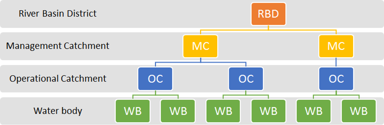
Catchment hierarchy
The data is organised around a catchment hierarchy, where the larger units contain 1 or many of the smaller units. This runs largest to smallest as follows: River Basin District → Management Catchment → Operational catchment → Water body.
For example: Thames → Cotswold and the Vale → Upper Thames → Thames (Kemble to Waterhay Bridge)
Classifications
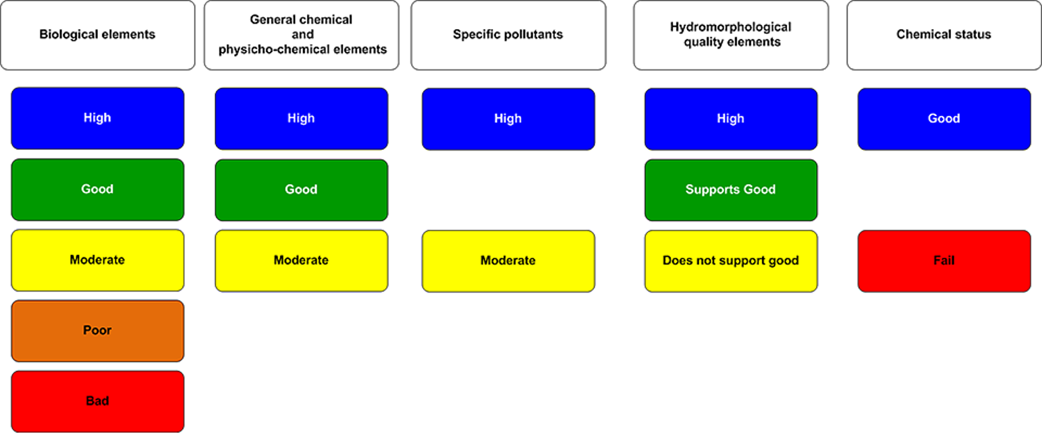
Classification hierarchy
Classifications are arranged according to the classification hierarchy. This is structured as follows: Overall water body status of potential → ecological, chemical or quantitative status (e.g. ecological) → Component (e.g. biological quality elements) → Element (e.g. fish).
For example: Overall Status → ecology → biology → fish
The type of water body will dictate what types of classification elements are assessed within it.


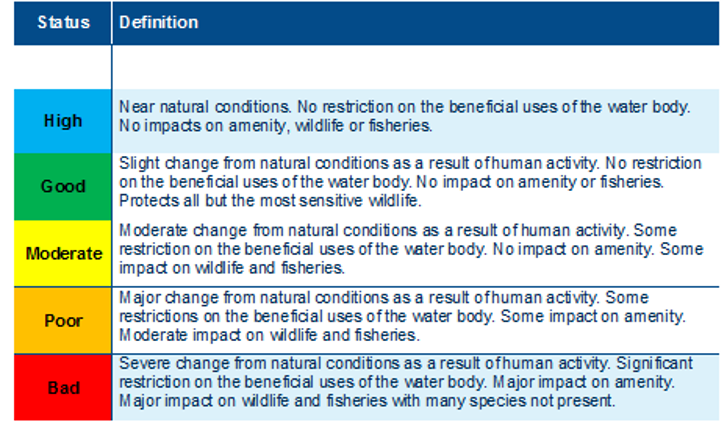
Status classifications

Classification methods statements
We also provide detailed methods statements for surface water and groundwater classifications on the river basin mangement plan webpages.
Surface water chemical classifications - reasons for reported improvements in 2015 cycle 2 data
The chemical status classifications in 2015 for cycle 2 can be quite different to those in cycle 2 for 2013 and 2014. These changes are explained by:
- Chemical status is determined by assessing compliance with environmental standards for chemicals that are listed in the Environmental Quality Standards (EQS) Directive (2008/105/EC) as amended by the Priority Substances Directive 2013/39/EU. Good Chemical Status is achieved if every EQS is met: a single EQS failure means Good Status for the water body cannot be achieved.
- EQS that have been set in biota have not yet been used to assess good status. Applying these biota standards may significantly affect Good Chemical Status in the future. However, exploratory work is first needed to find a robust approach to implement biota standards. This will ensure we can be confident about classification decisions and the action required. In addition to utilising long-term data sets from the marine environment, the Environment Agency has undertaken a pilot monitoring programme for these substances at selected freshwater sites. A preliminary assessment of data from freshwater sites over 2014-15 and transitional and coastal water datasets indicate that most substances would comply with their biota EQSs. However, we are predicting significant and widespread failures in the future for some chemicals which are highly regulated or banned, notably mercury and brominated flame retardants.
- The Environment Agency has developed 'chemical narratives' for the pollutants of most significance to England. These bring together information on emissions, risk assessments, trends and monitoring (in the water column and where available in biota). These provide a more in depth assessment of the current state of knowledge of these chemicals.
Objectives and predicted outcomes
Water body status objectives
For surface waters, objectives are set for ecological and chemical status. For artificial or heavily modified water bodies, objectives are set for ecological potential and chemical status. For groundwater, objectives are set for quantitative and chemical status.
Water body objectives consist of 2 pieces of information: the status (for example, good) and the date by which that status is planned to be achieved (for example, by 2021).
The status part of an objective is based on a prediction of the future status that would be achieved if technically feasible measures are implemented and, when implemented, would produce more benefits than they cost. The objective also takes into account the requirement to prevent deterioration and achieving protected area objectives.
The date part of an objective is the year by which the future status is predicted to be achieved. The date is determined by considering whether the measures needed to achieve the planned status are currently affordable, and once implemented, the time taken for the ecology or the groundwater to recover.
The water body objectives are:
- 'x' status by 2015: 2015 status matches the predicted future status or potential. Here the predicted future status has already been achieved and no further improvement in status is expected. The main environmental objective is to prevent deterioration in status between 2015 and 2021.
- 'x' status by 2021: there is confidence that as a result of the programme of measures, the water body will improve from its 2015 status or potential to achieve the predicted future status by 2021. The 'by 2015' date has been used to clearly distinguish water bodies and elements where the reported 2015 status matches the predicted future status (and so no further improvement is expected), from water bodies and elements where an improvement from the reported 2015 status is required to achieve the predicted future status by 2021.
- 'x' status by 2027: the deadline for achieving the status or potential has been extended to 2027. Where the time extension is due to ecological or groundwater recovery time, there is confidence that the measures needed to achieve the improvement in status are already in place or will be in place by 2021. Where the time extension is due to practical constraints delaying implementation of the measures, there is confidence the process of implementing the measures will begin before 2021. For the remaining objectives with a 2027 date, there is currently not enough confidence that the improvement in status can be achieved by an earlier date.
- 'x' status by 2040 or 'x' status by 2050 or 'x' status by 2060: the deadlines for achieving the planned status or potential have only been extended beyond 2027 where either ecological recovery time or groundwater recovery time will delay the achieving of the planned status. In these cases there is confidence that the measures needed to achieve the improvement in status are already in place or will be in place by 2021.
Where the status is less than good, this means that a less stringent objective has been set.
Challenges
Classification elements that are less than good status can have "reasons for not achieving good" (RNAG) assigned to them. Where an element has deteriorated (for example the status is thought to be getting worse), reasons for deterioration (RFDs) may be assigned. A number of tables are provided to provide more detail on these (for example Portsmouth harbour water body).
Investigations into classification status table
Investigations are carried out to improve our confidence that any classification failure or deterioration in status is associated with a genuine environmental problem.
Reasons for not achieving good (RNAG) and reasons for deterioration (RFDs) table
Shows the RNAG and RFD that we believe are impacting the classification elements in this water body.
Objectives table
There is an objective for each classification item assessed or calculated for this water body.
Protected Areas
On the water body pages the protected areas table shows the protected areas that are associated with water bodies. Clicking on any underlined entries in the PA Name and the More Information columns link to other sources of information on the protected area in question, for example opening Natural England's Designated Sites viewer.
The links between protected areas and water bodies are downloadable as CSVs from the water body pages and the River Basin District, Management Catchment and Operational Catchment pages.
Reported numbers of Shellfish water protected areas in the river basin management plan data are for 2021. There have been ten further Shellfish water protected areas created in 2022, these will be reported in future years
Chemical Status
For the 2019 assessment of chemical status we have changed some methods and increased our evidence base. Due to these changes, all water bodies now fail chemical status and this assessment is not comparable to previous years assessments.
There are four groups of global pollutants (uPBTs) causing these failures. There is actually little underlying change in chemical status for chemicals that are not uPBTs. The slight difference is attributable to newly introduced substances, such as cypermethrin. If uPBTs are excluded then chemical status assessment is comparable to previous years assessments.
You can view maps of chemical status classification with and without uPBTs causing failures on the river basin management plan map viewer.
The four groups of global pollutants (uPBTs) that cause the significant change in chemical classification are: polybrominated diphenyl ethers (PBDEs - a group of brominated flame retardants); Mercury; certain Polycyclic aromatic hydrocarbons (PAHs) and Perfluorooctane sulfonate (PFOS) a group of per-and polyfluoroalkyl substances (PFAS) which is being assessed for the first time.
What is Open Data?
Open data is data that's available to everyone to access, use and share. Want to know more, see what is open data and why should we care?
Open data from the Environment Agency is often made available under the Open Government Licensing Framework and the version of the Open Government Licence that is current at the time of issue.