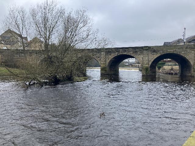
The bathing water site, known as the Wharfe at Wilderness Carpark is located on the
River Wharfe either side of Wetherby Bridge to the eastern end of the town of Wetherby
in West Yorskhire. The site can be accessed from the Wilderness Carpark and stretches
from below the weir to the Bandstand and picnic area just to the west of the car park.
Bathing water quality may sometimes be affected by storm, emergency and surface water
outfalls. Storm overflows may operate during and following periods of heavy rainfall
when the sewer system becomes overwhelmed by the amount of surface water entering.
The overflows prevent sewage from backing up pipes and flooding properties.
There are 2 storm overflows in the vicinity of the bathing water. Wetherby High
Street CSO discharges just to the east of Wetherby Bridge and a further CSO, Scott
Lane CSO is situated above the weir on the northern bank of the river.
The Environment Agency works with the water companies, local authorities and others
to investigate any sources of contamination and to improve water quality at local
bathing waters.
Modern sewerage systems have two separate systems, one takes foul sewage to sewage
treatment, the other takes rainwater runoff through surface water drains to rivers,
lakes and the sea. Misconnections occur when waste water pipes are plumbed into surface
water drains instead of the foul water sewerage system. This can give rise to pollution
when the waste water is discharged directly to the environment through the surface
water drain. For example, a washing machine or toilet may be incorrectly plumbed so
that it discharges to the surface drain rather than the foul sewage drain.
There are no active pollution risk forecasts made at this bathing water. However any
bathing water has the potential to be affected by a pollution incident and if this
occurs a pollution risk warning with associated advice against bathing will be issued
on this website.
There are no discharges of treated sewage effluent in the area of the bathing water.
Wetherby Sewage Treatment works discharges into the River Wharfe downstream of the
bathing water.
Environment Agency samplers make observations of litter present on the beach at every
visit, this includes assessments of sewage debris, litter and tar.
The River Wharfe above Wetherby is part of the wider Middle Wharfe and Washburn catchment
which covers the area from Appletreewick down to Collingham including Bolton Abbey
and the market towns of Ilkley and Otley. There are a number of reservoirs in this
catchment including Thruscross, Fewston and Swinsty in the Washburn Valley. Most
of the moors and fells in the Middle Wharfe are designated SACs and SPAs. Ilkley Moor
in the Washburn is also a SAC/SPA.
Seaweed (macroalgae) and phytoplankton (microscopic algae) are a natural part of the
marine and freshwater environment. Below we note whether these have been recorded
in quantities sufficient to be a nuisance.
The majority of sewers in England are “combined sewers” and carry both sewage and
surface water from roofs and drains. A storm overflow operates during heavy rainfall
when the sewerage system becomes overwhelmed by the amount of surface water. The overflow
prevents sewage from backing up pipes and flooding properties and gardens. An emergency
overflow will only operate infrequently, for example due to pump failure or blockage
in the sewerage system.
Heavy rain falling on pavements and roads often flows into surface water drains or
highway drains, ending up in local rivers and ultimately the sea. The quality of bathing
water may be adversely affected as a result of such events.
It is the Environment Agency's role to drive improvement of water quality at bathing
waters that are at risk of failing higher standards. It is natural for water to run
off the land to the sea. Water quality at a bathing water is dependent upon the type
and area of land (the catchment) draining to the water and the activities undertaken
in that catchment.


