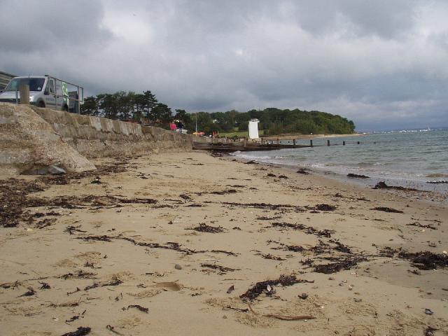
St Helens is a small bay situated on the east coast of the Isle of Wight at the mouth
of Bembridge Harbour. Measuring less than 1km in length, the sandy beach slopes from
the seawall into the harbour entrance channel. There is a café and beach huts on the
promenade that stretches along the beach, with sand dunes at the rear.
St Helens Duver storm overflow is at the north end of the beach and The Point Bembridge
storm overflow is opposite the south end of the beach. These outfalls can discharge
when heavy rainfall overwhelms the sewerage system but are designed to ensure that
bathing water compliance is not affected.
For the four year (2020-2023) assessment period where data is available, seaweed (macroalgae)
was not assessed as being sufficient to be objectionable, but was observed as being
present on 88% of visits. The shore can become covered with seaweed, depending on
tides and the weather. Groynes, rocks and other fixed objects may have a covering
of seaweed which can be slippery.
Modern sewerage systems have two separate systems, one takes foul sewage to sewage
treatment, the other takes rainwater runoff through surface water drains to rivers,
lakes and the sea. Misconnections occur when waste water pipes are plumbed into surface
water drains instead of the foul water sewerage system. This can give rise to pollution
when the waste water is discharged directly to the environment through the surface
water drain. For example, a washing machine or toilet may be incorrectly plumbed so
that it discharges to the surface drain rather than the foul sewage drain.
For the four year (2020-2023) assessment period where data is available, phytoplankton
(microscopic algae) was not assessed as being sufficient to be objectionable, but
was observed as being present on 7% of visits. Microscopic algae (phytoplankton) increase
in number at certain times of the year. This process is known as a phytoplankton bloom.
Blooms of phytoplankton can result in the water appearing discoloured or a foam forming
on the water.
The risks to human health from contact, ingestion or inhalation with marine algae
that currently occur in UK coastal waters are considered to be low. However, some
individuals may be more sensitive and display some reactions.
A common marine algae found in UK coastal waters is Phaeocystis, which is often mistaken
for sewage as it forms foam and a brown scum, but it is non-toxic.
There are no active pollution risk forecasts made at this bathing water. However any
bathing water has the potential to be affected by a pollution incident and if this
occurs a pollution risk warning with associated advice against bathing will be issued
on this website.
Within the Yar catchment there are numerous storm, emergency and surface water outfalls
that discharge to the rivers and ditches. The Yar, which flows through Bembridge Harbour,
affects the bathing water at low tide. Monitoring has shown that this is not a significant
source of bathing water pollution.
The Sandown sewage treatment works outfall is over 9km away and Budds Farm sewage
treatment works is about 5km to the north east. There is a small sewage treatment
works within the harbour. These outfalls are designed to ensure that bathing water
is protected.
Environment Agency samplers make observations of litter present on the beach at every
visit, this includes assessments of sewage debris, litter and tar. At St Helens for
the four year (2020-2023) assessment period where data is available, sewage debris
was not assessed as being sufficient to be objectionable, but was observed as being
present on 2% of visits. Litter was assessed as being sufficient to be objectionable
for 2% of visits, with 81% of visits noting the presence of litter. Tarry residue
was not noted at this site.
The natural drainage (hydrological) catchment surrounding the bathing water is about
9300 hectares. About one quarter of the Isle of Wight drains through the Eastern Yar
into Bembridge harbour. Much of the catchment is rural but also includes most of Shanklin
and Sandown towns.
Seaweed (macroalgae) and phytoplankton (microscopic algae) are a natural part of the
marine and freshwater environment. Below we note whether these have been recorded
in quantities sufficient to be a nuisance.
The majority of sewers in England are “combined sewers” and carry both sewage and
surface water from roofs and drains. A storm overflow operates during heavy rainfall
when the sewerage system becomes overwhelmed by the amount of surface water. The overflow
prevents sewage from backing up pipes and flooding properties and gardens. An emergency
overflow will only operate infrequently, for example due to pump failure or blockage
in the sewerage system.
Heavy rain falling on pavements and roads often flows into surface water drains or
highway drains, ending up in local rivers and ultimately the sea. The quality of bathing
water may be adversely affected as a result of such events.
It is the Environment Agency role to drive improvement of water quality at bathing
waters that are at risk of failing higher standards. It is natural for water to run
off the land to the sea. Water quality at a bathing water is dependent upon the type
and area of land (the catchment) draining to the water and the activities undertaken
in that catchment.


