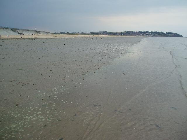
Leysdown is a traditional resort beach on the Isle of Sheppey. The gently sloping
beach is mostly sandy, with some shell and shingle, and there is plenty of shallow
water available as the tide retreats. The beach is bounded by flood defences and backed
by a promenade.
Swalecliffe Long Sea Outfall (11 km from the bathing water) was upgraded to further
treatment in 2001 and later received ultraviolet disinfection to protect shellfish
water quality. Prior to 2001 Southern Water undertook repairs to sections of leaking
sewers in Leysdown.
As part of Southern Water’s Bathing Water Enhancement Programme (from 2016 to 2019),
Southern Water have worked with partners and delivered solutions to improve bathing
water quality. This included upgrading their sewerage infrastructure within the Leysdown
catchment in 2018.
Prior to 2001 investigations focussed on sewer leaks and also misconnections causing
contamination of a surface water discharge to the bathing water. Since 2018, the Environmment
Agency have been working with Southern Water Services (SWS) and Swale Borough Council
(SBC) in order to identify possible sources of pollution. The Environment Agency
also introduced a DNA tracing technique that helps us identify whether sources of
faecal pollution are human or animal. Actions from these investigations are detailed
in the paragraphs below.
For the four year (2020-2023) assessment period where data is available, seaweed (macroalgae)
was not assessed as being sufficient to be objectionable, but was observed as being
present on 95% of visits. The bathing water can become covered with seaweed, depending
on tides and the weather. Groynes, rocks and other fixed objects may have a covering
of seaweed which can be slippery.
Modern sewerage systems have two separate systems, one takes foul sewage to sewage
treatment, the other takes rainwater runoff through surface water drains to rivers,
lakes and the sea. Misconnections occur when waste water pipes are plumbed into surface
water drains instead of the foul water sewerage system. This can give rise to pollution
when the waste water is discharged directly to the environment through the surface
water drain. For example, a washing machine or toilet may be incorrectly plumbed so
that it discharges to the surface drain rather than the foul sewage drain.
For the four year (2020-2023) assessment period where data is available, phytoplankton
(microscopic algae) was assessed as being sufficient to be objectionable for 2% of
visits, with 0% of visits noting the presence of phytoplankton (microscopic algae).
Phytoplankton (microscopic algae) increase in number at certain times of the year.
This process is known as a phytoplankton bloom. Blooms of phytoplankton can result
in the water appearing discoloured or a foam forming on the water.
The risks to human health from contact, ingestion or inhalation with marine algae
that currently occur in UK coastal waters are considered to be low. However, some
individuals may be more sensitive and display some reactions.
A common marine algae found in UK coastal waters is Phaeocystis, which is often mistaken
for sewage as it forms foam and a brown scum, but it is non-toxic.
There are no active pollution risk forecasts made at this bathing water. However any
bathing water has the potential to be affected by a pollution incident and if this
occurs a pollution risk warning with associated advice against bathing will be issued
on this website.
There are no riverine inputs into the bathing water but there is a drainage ditch
that discharge to sea 1.2 km northwest of the bathing water sampling point, and this
may receive storm and emergency sewage overflows in wet weather. The mouth of the
Swale (which separates the Isle of Sheppey from the mainland) is 4 km to the southeast.
Environment Agency samplers make observations of litter present on the beach at every
visit, this includes assessments of sewage debris, litter and tar. At Leysdown for
the four year (2020-2023) assessment period where data is available, sewage debris
was not noted at this site. Litter was not assessed as being sufficient to be objectionable,
but was observed as being present on 95% of visits. Tarry residue was not noted at
this site.
The natural drainage (hydrological) catchment surrounding the bathing water is small
at approximately 40 hectares. The catchment is predominantly urban, comprising part
of the town of Leysdown.
Seaweed (macroalgae) and phytoplankton (microscopic algae) are a natural part of the
marine and freshwater environment. Below we note whether these have been recorded
in quantities sufficient to be a nuisance.
The majority of sewers in England are “combined sewers” and carry both sewage and
surface water from roofs and drains. A storm overflow operates during heavy rainfall
when the sewerage system becomes overwhelmed by the amount of surface water. The overflow
prevents sewage from backing up pipes and flooding properties and gardens. An emergency
overflow will only operate infrequently, for example due to pump failure or blockage
in the sewerage system.
Heavy rain falling on pavements and roads often flows into surface water drains or
highway drains, ending up in local rivers and ultimately the sea. The quality of bathing
water may be adversely affected as a result of such events.
It is the Environment Agency role to drive improvement of water quality at bathing
waters that are at risk of failing higher standards. It is natural for water to run
off the land to the sea. Water quality at a bathing water is dependent upon the type
and area of land (the catchment) draining to the water and the activities undertaken
in that catchment.


