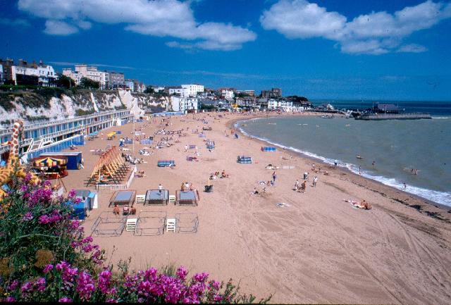
Viking Bay in Broadstairs is a 300 metre sandy horse-shoe shaped bay, with cliff-top
promenade, harbour pier and boardwalk. The small harbour is home to working boats,
an active sailing club and resort facilities.
Viking Bay bathing water could be affected by discharges from storm overflows that
can occur when heavy rainfall overwhelms the sewerage system. The Winterstoke storm
overflow at Ramsgate is less than 3 km to the south and the North Foreland storm overflow
is offshore nearly 5 km to the north east. These outfalls are designed to protect
bathing water compliance.
Prior to March 2007 there was a screened crude sewage discharge from the North Foreland
5 km long sea outfall. There was also a storm discharge from a 400 metres outfall
from the same pumping station. In March 2007 the North Foreland long sea outfall became
a high frequency storm overflow and the short outfall was converted to an emergency
outfall. Sewage flows were diverted to full treatment (including UV disinfection)
at Weatherlees sewage treatment works before being discharged via the Margate long
sea outfall.
Under the programme of works for Southern Water (from 2020 to 2022) investigations
within the catchment were carried out. This will help to identify where bathing water
improvements may be needed in the future.
This bathing water failed standards in 1996 and investigations identified and repaired
two areas of collapsed and silted up foul sewer in Harbour Street. Following a failure
in 2004, a series of investigations were carried out between 2004 and 2007 and since
2015. Many potential sources of contamination were investigated which pointed to the
fact that the surface water outfall is the likely source of contamination, together
with strandline debris. It is likely that diffuse sources typical of an urban catchment
all contribute to the contamination. Measures to reduce contamination in the surface
water system are on-going.
A partnership group between the Environment Agency, Thanet District Council, Kent
County Council and Southern Water has been formed. The aim of the partnership is
to work together to better understand risks to bathing water quality and put measures
in place to make improvements.
For the four year (2020-2023) assessment period where data is available, seaweed (macroalgae)
was assessed as being sufficient to be objectionable for 24% of visits, with 68% of
visits noting the presence of seaweed (macroalgae). The shore can become covered with
seaweed, depending on tides and the weather. Groynes, rocks and other fixed objects
may have a covering of seaweed which can be slippery.
Modern sewerage systems have two separate systems, one takes foul sewage to sewage
treatment, the other takes rainwater runoff through surface water drains to rivers,
lakes and the sea. Misconnections occur when waste water pipes are plumbed into surface
water drains instead of the foul water sewerage system. This can give rise to pollution
when the waste water is discharged directly to the environment through the surface
water drain. For example, a washing machine or toilet may be incorrectly plumbed so
that it discharges to the surface drain rather than the foul sewage drain.
For the four year (2020-2023) assessment period where data is available, phytoplankton
(microscopic algae) was assessed as being sufficient to be objectionable for 2% of
visits, with 7% of visits noting the presence of phytoplankton (microscopic algae).
Phytoplankton (microscopic algae) increase in number at certain times of the year.
This process is known as a phytoplankton bloom. Blooms of phytoplankton can result
in the water appearing discoloured or a foam forming on the water.
The risks to human health from contact, ingestion or inhalation with marine algae
that currently occur in UK coastal waters are considered to be low. However, some
individuals may be more sensitive and display some reactions.
A common marine algae found in UK coastal waters is Phaeocystis, which is often mistaken
for sewage as it forms foam and a brown scum, but it is non-toxic.
This bathing water is subject to short term pollution procedures. The Environment
Agency makes a daily pollution risk forecast at this site based on the effects of
rain, tide, wind and seasonality on bathing water quality. These factors affect the
levels of bacteria that get washed into the sea from livestock, sewage and urban drainage
via rivers and streams and how they disperse.
When these factors combine to make short term pollution likely we issue a pollution
risk warning on this website and the beach manager will display a sign advising against
bathing at the bathing water. After a short term pollution event, levels of bacteria
typically return to normal after a day or so but it’s possible to have several warning
days in a row. Details of the work to reduce the sources of bacteria at this bathing
water are detailed in this profile.
In 2023 12 pollution risk warnings were issued for this bathing water.
All bathing waters have the potential to be affected by a pollution incident and if
this occurs a pollution risk warning will be issued with associated advice against
bathing on this website.
Environment Agency samplers make observations of litter present on the beach at every
visit, this includes assessments of sewage debris, litter and tar. At Broadstairs,
Viking Bay for the four year (2020-2023) assessment period where data is available,
sewage debris was not noted at this site. Litter was not assessed as being sufficient
to be objectionable, but was observed as being present on 96% of visits. Tarry residue
was not noted at this site.
There are no natural surface water courses that flow to the coast from the local catchment
of about 240 hectares. The Stour catchment of about 823 square kilometres drains into
Pegwell Bay over 6 km to the south. The Stour catchment includes Ashford, Canterbury,
Sandwich and much of Deal.
Seaweed (macroalgae) and phytoplankton (microscopic algae) are a natural part of the
marine and freshwater environment. Below we note whether these have been recorded
in quantities sufficient to be a nuisance.
The majority of sewers in England are “combined sewers” and carry both sewage and
surface water from roofs and drains. A storm overflow operates during heavy rainfall
when the sewerage system becomes overwhelmed by the amount of surface water. The overflow
prevents sewage from backing up pipes and flooding properties and gardens. An emergency
overflow will only operate infrequently, for example due to pump failure or blockage
in the sewerage system.
Heavy rain falling on pavements and roads often flows into surface water drains or
highway drains, ending up in local rivers and ultimately the sea. The quality of bathing
water may be adversely affected as a result of such events.
It is the Environment Agency role to drive improvement of water quality at bathing
waters that are at risk of failing higher standards. It is natural for water to run
off the land to the sea. Water quality at a bathing water is dependent upon the type
and area of land (the catchment) draining to the water and the activities undertaken
in that catchment.


