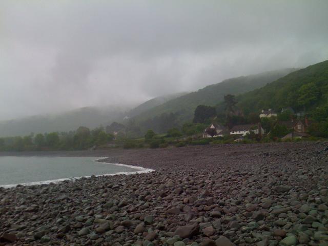
Porlock Bay is between Hurlestone Point and Porlock Weir in Somerset overlooking the
Bristol Channel. Porlock Weir is a small settlement with a harbour about two and a
half kilometres west of the village of Porlock. It has a pebble beach, approximately
one kilometre wide, backed by Porlock Ridge and Saltmarsh to the east.
There is an emergency overflow from Porlock Weir pumping station that discharges to
the bathing water 230m from the Environment Agency monitoring point. The operation
of the overflow can lead to a drop in bathing water quality. This bathing water is
included in the Surfers Against Sewage “Safer Seas Service”. This service can alert
you to Combined Storm Sewer Overflow discharges via a phone App and in addition, it
includes the Environment Agency Pollution Risk Forecast warnings where they are available.
Further details of the service can be found at - http://www.sas.org.uk/safer-seas-service/
In the past this bathing water was affected by continuous water company discharges
of untreated sewage from Porlock Weir, Porlock, and Bossington. The Wessex Water sewage
treatment scheme for the Porlock area was completed between 1995 and 2000. The scheme
included a sewage treatment works (STW) at Porlock which provides secondary treatment
and microfiltration or UV disinfection. The Porlock Weir, Porlock, and Bossington
discharges were transferred to Porlock STW in 1998, and the outfalls retained as pumping
station emergency overflows/combined sewer overflows.
For the four year (2020-2023) assessment period where data is available, seaweed (macroalgae)
was not assessed as being sufficient to be objectionable, but was observed as being
present on 41% of visits. This bathing water does not have a history of large amounts
of seaweed (macro algae).
For the four year (2020-2023) assessment period where data is available, phytoplankton
(microscopic algae) was not noted at this site. Phytoplankton (microscopic algae)
naturally increase in number at certain times of the year. This process is known as
a phytoplankton bloom. This bathing water does not have a history of phytoplankton
blooms.
The risks to human health from contact, ingestion or inhalation with marine algae
that currently occur in UK coastal waters are considered to be low. However, some
individuals may be more sensitive and display some reactions.
A common marine algae found in UK coastal waters is Phaeocystis, which is often mistaken
for sewage as it forms foam and a brown scum, but it is non-toxic.
There are no active pollution risk forecasts made at this bathing water. However any
bathing water has the potential to be affected by a pollution incident and if this
occurs a pollution risk warning with associated advice against bathing will be issued
on this website.
Streams and rivers are typically affected by human sewage, animal slurry and runoff
from roads. The Hawkcombe Stream enters the sea near this beach, and does not affect
the bathing water quality.
The outfall from Porlock STW discharges to the sea 1.9km from the shore of this bathing
water. This discharge is treated using microfiltration or UV disinfection and designed
to protect bathing water quality.
Environment Agency samplers make observations of litter present on the beach at every
visit, this includes assessments of sewage debris, litter and tar. At Porlock Weir
for the four year (2020-2023) assessment period where data is available, sewage debris
was not noted at this site. Litter was not assessed as being sufficient to be objectionable,
but was observed as being present on 62% of visits. Tarry residue was not noted at
this site.
The catchment surrounding Porlock Weir is approximately 5,700 hectares. The Hawkcombe
Stream is approximately seven and a half kilometres long. It flows through a steep
sided wooded valley, through the village of Porlock and enters the sea at the eastern
end of the beach.
The rivers Horner and Aller are approximately eight and a half kilometres and six
and a half kilometres long respectively, and rise as several small streams on the
northern edge of Exmoor National Park. The rivers meet in the village of Bossington
before entering Porlock Bay near Hurlestone point approximately 2.7km to the east
of the Environment Agency monitoring point. The catchment is agricultural, with around
20 farms.
Seaweed (macroalgae) and phytoplankton (microscopic algae) are a natural part of the
marine and freshwater environment. Below we note whether these have been recorded
in quantities sufficient to be a nuisance.
The majority of sewers in England are “combined sewers” and carry both sewage and
surface water from roofs and drains. A storm overflow operates during heavy rainfall
when the sewerage system becomes overwhelmed by the amount of surface water. The overflow
prevents sewage from backing up pipes and flooding properties and gardens. An emergency
overflow will only operate infrequently, for example due to pump failure or blockage
in the sewerage system.
Heavy rain falling on pavements and roads often flows into surface water drains or
highway drains, ending up in local rivers and ultimately the sea. The quality of bathing
water may be adversely affected as a result of such events.
It is the Environment Agency role to drive improvement of water quality at bathing
waters that are at risk of failing higher standards. It is natural for water to run
off the land to the sea. Water quality at a bathing water is dependent upon the type
and area of land (the catchment) draining to the water and the activities undertaken
in that catchment.


