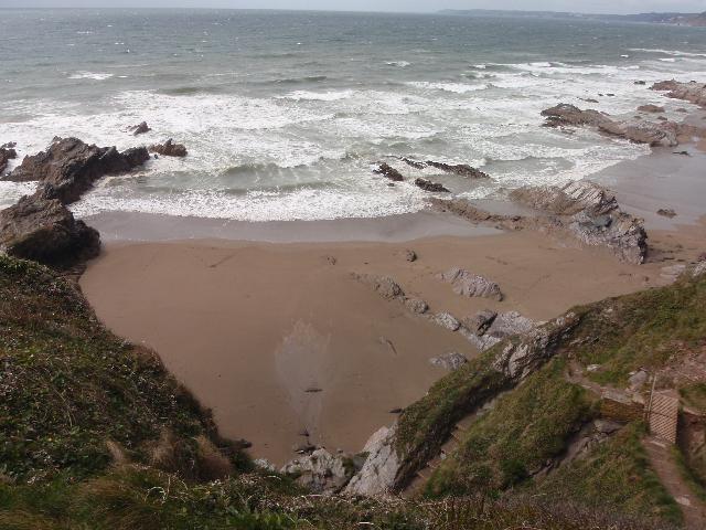
Sharrow beach is in Whitsand Bay on the south coast of Cornwall. It is a small sand
and rock cove approximately 300 metres wide, backed by steep cliffs, and Sharrow Point
headland to the east.
For the three year (2021-2023) assessment period where data is available, seaweed
(macroalgae) was not assessed as being sufficient to be objectionable, but was observed
as being present on 67% of visits. This bathing water does not have a history of large
amounts of seaweed (macro algae).
For the three year (2021-2023) assessment period where data is available, phytoplankton
(microscopic algae) was not assessed as being sufficient to be objectionable, but
was observed as being present on 4% of visits. Phytoplankton (microscopic algae) naturally
increase in number at certain times of the year. This process is known as a phytoplankton
bloom. This bathing water does not have a history of phytoplankton blooms.
The risks to human health from contact, ingestion or inhalation with marine algae
that currently occur in UK coastal waters are considered to be low. However, some
individuals may be more sensitive and display some reactions.
A common marine algae found in UK coastal waters is Phaeocystis, which is often mistaken
for sewage as it forms foam and a brown scum, but it is non-toxic.
There are no active pollution risk forecasts made at this bathing water. However any
bathing water has the potential to be affected by a pollution incident and if this
occurs a pollution risk warning with associated advice against bathing will be issued
on this website.
Environment Agency samplers make observations of litter present on the beach at every
visit, this includes assessments of sewage debris, litter and tar. At Sharrow for
the three year (2021-2023) assessment period where data is available, sewage debris
was not noted at this site. Litter was not assessed as being sufficient to be objectionable,
but was observed as being present on 34% of visits. Tarry residue was not noted at
this site.
There is one arable farm in the bathing water catchment. During and after periods
of heavy rainfall, runoff to the streams from agricultural land is greatly increased,
and the quality of the bathing water can be reduced.
The catchment surrounding Sharrow is approximately 95 hectares. There are two unnamed
streams that enter the sea at the bathing water. The first is approximately 500 metres
long and enters the sea at Sharrow Point. The second is approximately one kilometre
long and flows past the village of Freathy before entering the sea approximately 300m
southeast of Sharrow Point. The steep catchment means rain runs off rapidly into the
streams. Land use is arable, with one farm, and Freathy village at the coast. The
beach at Sharrow is within the Rame Head to Whitsand Bay Site of Special Scientific
Interest (SSSI).
Seaweed (macroalgae) and phytoplankton (microscopic algae) are a natural part of the
marine and freshwater environment. Below we note whether these have been recorded
in quantities sufficient to be a nuisance.
The majority of sewers in England are “combined sewers” and carry both sewage and
surface water from roofs and drains. A storm overflow operates during heavy rainfall
when the sewerage system becomes overwhelmed by the amount of surface water. The overflow
prevents sewage from backing up pipes and flooding properties and gardens. An emergency
overflow will only operate infrequently, for example due to pump failure or blockage
in the sewerage system.
Heavy rain falling on pavements and roads often flows into surface water drains or
highway drains, ending up in local rivers and ultimately the sea. The quality of bathing
water may be adversely affected as a result of such events.
It is the Environment Agency role to drive improvement of water quality at bathing
waters that are at risk of failing higher standards. It is natural for water to run
off the land to the sea. Water quality at a bathing water is dependent upon the type
and area of land (the catchment) draining to the water and the activities undertaken
in that catchment.


