Linked Data API
Show Search Form
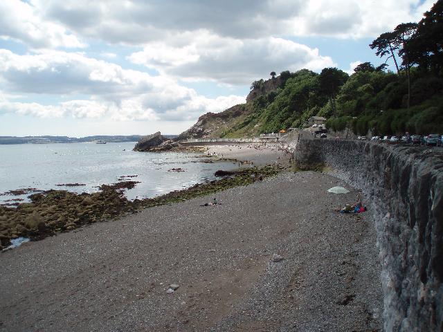
2024 Bathing Water Profile for Meadfoot
http://environment.data.gov.uk/data/bathing-water-profile/ukk4200-23600/2024:1
| pollution risk forecasting |  |
 |
|||||||||||||||||||||||
|---|---|---|---|---|---|---|---|---|---|---|---|---|---|---|---|---|---|---|---|---|---|---|---|---|---|
| season finish date |   |
||||||||||||||||||||||||
| season start date | |
||||||||||||||||||||||||
| sampling frequency | 10 | |
|||||||||||||||||||||||
| bathing water description | Meadfoot is on the south coast of Devon. It is a shingle and rocky beach resort, approximately 800 metres wide, backed by cliffs. | |
|||||||||||||||||||||||
| controller name | Torbay | |
|||||||||||||||||||||||
| county name | Devon | |
|||||||||||||||||||||||
| eso outfalls statement | This bathing water is included in the Surfers Against Sewage “Safer Seas Service”. This service can alert you to Combined Storm Sewer Overflow discharges via a phone App and in addition, it includes the Environment Agency Pollution Risk Forecast warnings where they are available. Further details of the service can be found at - http://www.sas.org.uk/safer-seas-service/ | |
|||||||||||||||||||||||
| history statement | In the past the main affect at this bathing water was the continuous untreated outfall at Hopes Nose. This discharge was removed as part of South West Water's sewage treatment scheme for Torbay which was commissioned in May 2002. The scheme consisted of extensive resewerage and improvements to unsatisfactory CSOs and pumping stations. The area is served by combined sewers, which drain by gravity to Ilsham Valley pumping station from where flows are pumped to Torbay for treatment. A sewage works was built at Brokenbury Quarry in 2002 where effluent receives secondary treatment and ultraviolet (UV) disinfection before discharge through an extended outfall at Sharkham Point (SX9396054570). Flows from the untreated outfall at Hopes Nose were transferred to Brokenbury by June 2003, and this outfall was retained as a CSO. Storm overflow event duration monitoring (EDM) was installed at the Ilsham Valley pumping station by December 2011. | |
|||||||||||||||||||||||
| macro algae statement | For the four year (2020-2023) assessment period where data is available, seaweed (macroalgae) was not assessed as being sufficient to be objectionable, but was observed as being present on 62% of visits. This bathing water does not have a history of large amounts of seaweed (macro algae). | |
|||||||||||||||||||||||
| phytoplankton statement | For the four year (2020-2023) assessment period where data is available, phytoplankton (microscopic algae) was not assessed as being sufficient to be objectionable, but was observed as being present on 3% of visits. Phytoplankton (microscopic algae) naturally increase in number at certain times of the year. This process is known as a phytoplankton bloom. This bathing water does not have a history of phytoplankton blooms. The risks to human health from contact, ingestion or inhalation with marine algae that currently occur in UK coastal waters are considered to be low. However, some individuals may be more sensitive and display some reactions. A common marine algae found in UK coastal waters is Phaeocystis, which is often mistaken for sewage as it forms foam and a brown scum, but it is non-toxic. | |
|||||||||||||||||||||||
| pollution risk forecast statement | There are no active pollution risk forecasts made at this bathing water. However any bathing water has the potential to be affected by a pollution incident and if this occurs a pollution risk warning with associated advice against bathing will be issued on this website. | |
|||||||||||||||||||||||
| version string | 1 | |
|||||||||||||||||||||||
| visible pollution statement | Environment Agency samplers make observations of litter present on the beach at every visit, this includes assessments of sewage debris, litter and tar. At Meadfoot for the four year (2020-2023) assessment period where data is available, sewage debris was not noted at this site. Litter was not assessed as being sufficient to be objectionable, but was observed as being present on 24% of visits. Tarry residue was not noted at this site. | |
|||||||||||||||||||||||
| zoi description | The catchment surrounding Meadfoot is approximately 125 hectares. The Ilsham Valley Stream is approximately 600m long and is mostly open apart from a section channelled under Meadfoot Sea Road. The stream enters the sea at the far end of Meadfoot beach approximately 600m from the Environment Agency monitoring point. The catchment is urban. | |
|||||||||||||||||||||||
| bathing water |
|
||||||||||||||||||||||||
| local authority | Torbay | |
|||||||||||||||||||||||
| season interval |
|
||||||||||||||||||||||||
| source | row=0269 | ||||||||||||||||||||||||
| standard language collection |
|
||||||||||||||||||||||||
| web res image | ukk4200-23600_1-webres.jpg | ||||||||||||||||||||||||