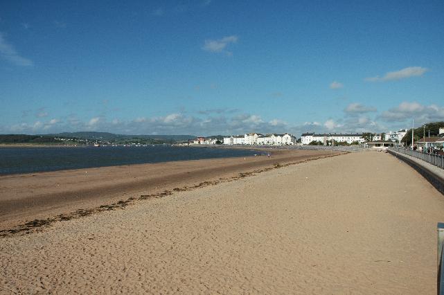
Exmouth is on the south coast of Devon at the mouth of the Exe Estuary. It is a large
sandy beach resort, approximately 1.8 kilometres wide, backed by the promenade and
town.
There are a number of permitted storm overflows that discharge into the Exmouth bathing
water. Historical evidence and data indicate that these overflows have the potential
to affect bathing water quality during storm conditions. However, the impact can vary
depending on factors such as tidal state and weather conditions. Additionally, it
is important to note that certain overflows are assigned for investigative purposes
and may not have an actual impact.
These include:
Maer Road pumping station & Combined Sewer Overflow
Imperial road Combined Sewer Overflow
Hartopp road pumping station
Phear park pumping station
Real time monitoring of these overflows can be found on South West Water Waterfit
Website.
The sewage treatment scheme for Exmouth which provides secondary treatment and ultraviolet
(UV) disinfection, was completed by South West Water in 1997. Extensive sewer rehabilitation
works to relieve sewer flooding problems in Exmouth were also undertaken at that time.
The outfall from Exmouth STW is off Straight Point and was extended further offshore
in 1998.
UV disinfection was installed at Countess Wear STW (Exeter) by mid-December 2001.
Improvements to Starcross STW on the western side of the Exe Estuary, and nine combined
sewer overflows (CSO) discharging to the River Exe were completed in 2002. The storm
tank at Countess Wear STW was completed by mid-December 2002. During 2011 and 2012,
storm overflow event duration monitoring (EDM) was installed at the Exmouth STW storm
overflow and at five CSOs discharging to the Exe estuary.
To protect shellfish water quality in the River Exe improvements were made to eleven
CSOs within the Countess Wear STW (Exeter) sewerage catchment by March 2018. These
improvements included UV disinfection of the Countess Wear STW storm discharge. A
further nine CSOs are scheduled for improvements by June 2021. UV disinfection is
scheduled to be in place at Kenn and Kennford STW by June 2021.
To better manage bathing water quality the Environment Agency have used a DNA tracing
technique to help identify whether sources of faecal pollution are human or animal.
We have historically investigated the Littleham Brook catchment and taken action to
minimise the effects from agricultural pollution sources.
For the four year (2020-2023) assessment period where data is available, seaweed (macroalgae)
was assessed as being sufficient to be objectionable for 18% of visits, with 70% of
visits noting the presence of seaweed (macroalgae). This bathing water does not have
a history of large amounts of seaweed (macro algae).
Wrongly connected domestic waste water pipes can also affect the bathing water quality.
Modern sewerage systems have two separate systems, one takes foul sewage to sewage
treatment, the other takes rainwater runoff through surface water drains to rivers,
lakes and the sea. Misconnections occur when waste water pipes are plumbed into surface
water drains instead of the foul water sewerage system. This can give rise to pollution
when the waste water is discharged directly to the environment through the surface
water drain. For example, a washing machine or toilet may be incorrectly plumbed so
that it discharges to the surface drain rather than the foul sewage drain.
For the four year (2020-2023) assessment period where data is available, phytoplankton
(microscopic algae) was not assessed as being sufficient to be objectionable, but
was observed as being present on 5% of visits. Phytoplankton increase in number at
certain times of the year and this process is known as a phytoplankton bloom. These
blooms can discolour the water or form as a foam on the water. Environment Agency
research shows this bathing water has a history of phytoplankton blooms.
The risks to human health from contact, ingestion or inhalation with marine algae
that currently occur in UK coastal waters are considered to be low. However, some
individuals may be more sensitive and display some reactions.
A common marine algae found in UK coastal waters is Phaeocystis, which is often mistaken
for sewage as it forms foam and a brown scum, but it is non-toxic.
This bathing water is subject to short term pollution procedures. The Environment
Agency makes a daily pollution risk forecast at this site based on the effects of
rain, wind and seasonality on bathing water quality. These factors affect the levels
of bacteria that get washed into the sea from livestock, sewage and urban drainage
via rivers and streams and how they disperse.
When these factors combine to make short term pollution likely we issue a pollution
risk warning on this website and the beach manager will display a sign advising against
bathing at the bathing water. After a short term pollution event, levels of bacteria
typically return to normal after a day or so but it’s possible to have several warning
days in a row. Details of the work to reduce the sources of bacteria at this bathing
water are detailed in this profile.
In 2023 8 pollution risk warnings were issued for this bathing water.
All bathing waters have the potential to be affected by a pollution incident and if
this occurs a pollution risk warning will be issued with associated advice against
bathing on this website.
Streams and rivers are typically affected by human sewage, animal slurry and runoff
from roads. The River Exe flows past the beach, and the Littleham Stream is piped
under the beach and enters the bathing water to the south of the Environment Agency
monitoring point. The Environment Agency have monitored the Littleham Stream at the
beach since 1992 and have found that water quality in the stream is temporarily worse
after heavy rainfall.
Environment Agency samplers make observations of litter present on the beach at every
visit, this includes assessments of sewage debris, litter and tar. At Exmouth for
the four year (2020-2023) assessment period where data is available, sewage debris
was not noted at this site. Litter was not assessed as being sufficient to be objectionable,
but was observed as being present on 67% of visits. Tarry residue was not noted at
this site.
There are dairy and beef farms in the catchment near to the bathing water. During
and after periods of heavy rainfall, runoff to the Littleham Brook from agricultural
land is greatly increased, and the quality of the bathing water can be reduced.
If any concerns arise, the Environment Agency will investigate and request immediate
remedial action from those responsible.
The Environment Agency have worked with businesses on the small industrial estate
at Littleham to ensure there is no effect on the bathing water quality from this site.
Exmouth bathing water is affected by the catchment surrounding the Littleham Brook,
which is approximately 600 hectares, and also by the enormous Exe Estuary catchment
which is approximately 150,000 hectares. The Littleham Brook is four and a half kilometres
long and flows southwest from Littleham Village through Green Farm and Maer Farm to
Maer Bridge where it is piped under the beach to the sea at Maer Rocks. The steep
catchment means rain runs off rapidly into the stream.
The Exe catchment extends from the moorland of Exmoor National Park at the source
of the River Exe, to the Exe Estuary at Exmouth. The main tributaries of the River
Exe are the rivers Culm, Barle, Clyst and Creedy. The Exe and Barle rise in the wet
open moorland of Exmoor, before flowing through steep-sided valleys with extensive
broad-leaved woodlands. The River Barle flows from northern Exmoor, to join the River
Exe at Exebridge. The River Culm rises in the Blackdown Hills and flows through the
Culm Valley to join the River Exe at Exeter. The River Creedy is a small river which
merges with the River Yeo at Crediton and meets the River Exe at Cowley Bridge. The
River Clyst rises near Cullompton, and flows through the Clyst Valley to join the
Exe Estuary near Exeter.
Land in the catchment is mainly used for agriculture. There are more than 50 dairy
and other livestock farms.
Seaweed (macroalgae) and phytoplankton (microscopic algae) are a natural part of the
marine and freshwater environment. Below we note whether these have been recorded
in quantities sufficient to be a nuisance.
The majority of sewers in England are “combined sewers” and carry both sewage and
surface water from roofs and drains. A storm overflow operates during heavy rainfall
when the sewerage system becomes overwhelmed by the amount of surface water. The overflow
prevents sewage from backing up pipes and flooding properties and gardens. An emergency
overflow will only operate infrequently, for example due to pump failure or blockage
in the sewerage system.
Heavy rain falling on pavements and roads often flows into surface water drains or
highway drains, ending up in local rivers and ultimately the sea. The quality of bathing
water may be adversely affected as a result of such events.
It is the Environment Agency role to drive improvement of water quality at bathing
waters that are at risk of failing higher standards. It is natural for water to run
off the land to the sea. Water quality at a bathing water is dependent upon the type
and area of land (the catchment) draining to the water and the activities undertaken
in that catchment.


