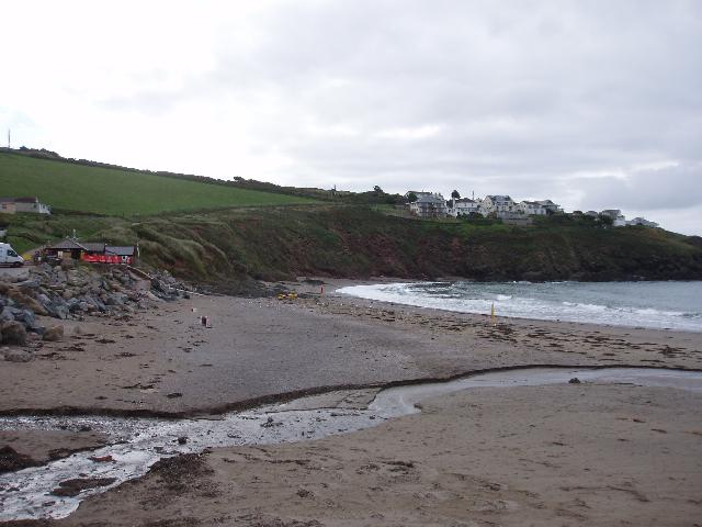
Challaborough is on the south coast of Devon. It is a sandy beach resort, approximately
350 metres wide, surrounded by cliffs and sand dunes. A stream flows onto the beach
to the sea.
There is an emergency/storm overflow from the Challaborough pumping station that discharges
to the Challaborough Stream 70m from the beach. There is an emergency/storm overflow
from the Warren Point pumping station that discharges to the sea 200m south of the
Environment Agency monitoring point. There is an emergency/storm overflow from the
Warren pumping station that discharges to the sea at Warren Point 400m south of the
Environment Agency monitoring point. There is an emergency/storm overflow from the
Bigbury and Challaborough STW that discharges to the sea at Warren Point 400m south
of the Environment Agency monitoring point. The operation of the overflows can lead
to a temporary drop in bathing water quality.
This bathing water is included in the Surfers Against Sewage “Safer Seas Service”.
This service can alert you to Combined Storm Sewer Overflow discharges via a phone
App and in addition, it includes the Environment Agency Pollution Risk Forecast warnings
where they are available. Further details of the service can be found at - http://www.sas.org.uk/safer-seas-service/
The South West Water sewage treatment scheme for Bigbury and Challaborough, which
provides secondary treatment, was completed in 1995. Following concerns over shellfish
quality in the Avon Estuary, South West Water also installed a temporary ultraviolet
(UV) disinfection plant at Aveton Gifford sewage treatment works (STW) in 1998. This
was replaced with a permanent UV installation in October 2001. Aveton Gifford STW
also received increased storm storage in February 2002.
Two emergency overflows at Bigbury and Warren Point were improved by April 2003, and
the combined sewer overflow/emergency overflow at Challaborough pumping station was
improved by April 2003. Storm overflow event duration monitoring (EDM) was installed
at these sites by December 2011.
The urban area of Challaborough immediately behind the beach is served by a combined
(surface and sewer) system. There are no outfalls from the system onto the beach.
For the four year (2020-2023) assessment period where data is available, seaweed (macroalgae)
was assessed as being sufficient to be objectionable for 3% of visits, with 91% of
visits noting the presence of seaweed (macroalgae). This bathing water has some history
of large amounts of seaweed (macro algae) and can become covered with large amounts
of seaweed at certain times of the year, depending on tides and the weather. Groynes
and rocks, platforms or other fixed objects may also develop a covering of seaweed
which can be slippery.
For the four year (2020-2023) assessment period where data is available, phytoplankton
(microscopic algae) was not noted at this site. Phytoplankton (microscopic algae)
naturally increase in number at certain times of the year. This process is known as
a phytoplankton bloom. These blooms can discolour the water or form as a foam on the
water. This bathing water does not have a history of phytoplankton blooms.
The risks to human health from contact, ingestion or inhalation with marine algae
that currently occur in UK coastal waters are considered to be low. However, some
individuals may be more sensitive and display some reactions.
A common marine algae found in UK coastal waters is Phaeocystis, which is often mistaken
for sewage as it forms foam and a brown scum, but it is non-toxic.
The Environment Agency makes a daily pollution risk forecast at this site based on
the effects of rain, sunlight and seasonality on bathing water quality. These factors
affect the levels of bacteria that get washed into the sea from livestock, sewage
and urban drainage via rivers and streams and how they disperse.
When these factors combine to cause a temporary reduction in water quality, we will
issue a pollution risk warning on this website. Water quality will typically return
to normal after a day or so, but it’s possible to have several warning days in a row.
Details of the work to reduce the sources of bacteria at this bathing water are detailed
in this profile.
In 2023 2 pollution risk warnings were issued for this bathing water.
All bathing waters have the potential to be affected by a pollution incident and if
this occurs a pollution risk warning will be issued with associated advice against
bathing on this website.
The Challaborough Stream flows across the beach to the north of the Environment Agency
monitoring point. The Environment Agency have monitored the Challaborough Stream at
the beach since 1987, and found that it is affected by runoff from farms further up
the catchment.
The outfall from Bigbury and Challaborough STW discharges to the sea at Warren Point
400m south of the Environment Agency monitoring point. This discharge is designed
to protect bathing water quality.
Environment Agency samplers make observations of litter present on the beach at every
visit, this includes assessments of sewage debris, litter and tar. At Challaborough
for the four year (2020-2023) assessment period where data is available, sewage debris
was not noted at this site. Litter was not assessed as being sufficient to be objectionable,
but was observed as being present on 65% of visits. Tarry residue was not noted at
this site.
The catchment of the Challaborough bathing water is largely agricultural with significant
areas of land used for livestock, most of which are beef and sheep. During and after
periods of heavy rainfall, runoff from agricultural areas to the River Avon is greatly
increased, and the quality of the bathing water may be reduced. In 2016 the Environment
Agency provided fencing to reduce livestock access to the water course.
The catchment surrounding Challaborough is approximately 15,000 hectares. The Challaborough
Stream is approximately two and a half kilometres (km) long and flows across the western
side of the beach. The River Avon is approximately one and a half kilometres to the
east. The River Avon and its major tributaries (the Bala Brook and the Glaze Brook)
rise on south Dartmoor. The Avon flows for 37 kilometres through the Avon Reservoir,
South Brent, Avonwick, Loddiswell and Aveton Gifford before reaching the estuary mouth
at Bantham and Bigbury on Sea. As the river flows from the open moorland, it has created
steep sided valleys with small enclosures mostly used for small scale livestock farming.
The steep catchment means rain runs off rapidly into the many small streams that feed
the River Avon.
The estuary of the Avon is tidal up as far as the weir at Aveton Gifford, and like
the other estuaries of South Devon, the original deep river valley has been flooded
by sea level rise, to create a wide expanse of water. The catchment is mostly agricultural,
with more than 50 farms.
Seaweed (macroalgae) and phytoplankton (microscopic algae) are a natural part of the
marine and freshwater environment. Below we note whether these have been recorded
in quantities sufficient to be a nuisance.
The majority of sewers in England are “combined sewers” and carry both sewage and
surface water from roofs and drains. A storm overflow operates during heavy rainfall
when the sewerage system becomes overwhelmed by the amount of surface water. The overflow
prevents sewage from backing up pipes and flooding properties and gardens. An emergency
overflow will only operate infrequently, for example due to pump failure or blockage
in the sewerage system.
Heavy rain falling on pavements and roads often flows into surface water drains or
highway drains, ending up in local rivers and ultimately the sea. The quality of bathing
water may be adversely affected as a result of such events.
It is the Environment Agency role to drive improvement of water quality at bathing
waters that are at risk of failing higher standards. It is natural for water to run
off the land to the sea. Water quality at a bathing water is dependent upon the type
and area of land (the catchment) draining to the water and the activities undertaken
in that catchment.


