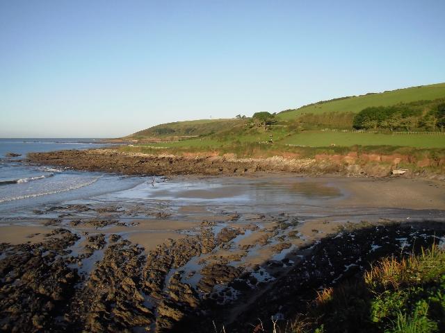
Wembury is on the south coast of Devon. It is a sand and rock beach resort, approximately
1.1 kilometres wide, backed by cliffs. Many rock pools are exposed at low tide and
a stream flows across the beach to the sea.
There is an emergency/storm overflow from Wembury pumping station, that discharges
to the Wembury Stream 50m upstream of the bathing water. The operation of the overflow
can lead to a temporary drop in bathing water quality.
This bathing water is included in the Surfers Against Sewage “Safer Seas Service”.
This service can alert you to Combined Storm Sewer Overflow discharges via a phone
App and in addition, it includes the Environment Agency Pollution Risk Forecast warnings
where they are available. Further details of the service can be found at - http://www.sas.org.uk/safer-seas-service/
From 1993, South West Water provided treatment by chemically assisted sedimentation
at Wembury sewage treatment works (STW). The sewage treatment scheme for Wembury,
which provides secondary treatment, was completed in 1998. Improvements were made
to the combined sewer overflow at the STW at that time.
Additional storm storage was provided at Wembury STW in 2002, together with improvements
to the treatment at Newton Ferrers STW in the Yealm Estuary to the east. Further improvements
to Wembury STW combined sewer overflow (CSO) were completed by March 2002.
Storm overflow event duration monitoring (EDM) was installed at Wembury pumping station
by May 2012.
To protect shellfish water quality in the Yealm estuary improvements were made to
Yealmpton STW and Yeamplton Pumping Station emergency/storm overflows by March 2016.
EDM was also installed at 6 other emergency/storm overflows by March 2018.
The Environment Agency carried out additional monitoring in the Wembury Stream in
2010 and 2015. DNA tracing techniques were used and identified the main source of
pollution to be from a ruminant source. This led to fencing being installed within
the catchment to prevent poaching and cattle access to the stream. A drainage survey
was carried out in 2015.
In 2018 Environment Agency monitoring of the Wembury Stream identified pollutants
associated with domestic grey water and sewage. Following this a drainage survey was
undertaken which identified a number of misconnections. We have worked with the property
owners to resolve these.
The Environment Agency have worked with Wembury Beach Liaison Group and Wembury Parish
Council to raise community awareness around avoiding misconnections and reducing risk
of sewer blockages, which can result in untreated water being discharged through emergency/storm
overflows. We are working with local stakeholders including Devon Wildlife Trust,
National Trust, South Devon AONB and local landowners to look at a range of possible
future improvements within the catchment.
For the four year (2020-2023) assessment period where data is available, seaweed (macroalgae)
was assessed as being sufficient to be objectionable for 40% of visits, with 58% of
visits noting the presence of seaweed (macroalgae). The bathing water can become covered
with large amounts of seaweed, depending on tides and the weather. This bathing water
has a history of large amounts of seaweed.
For the four year (2020-2023) assessment period where data is available, phytoplankton
(microscopic algae) was assessed as being sufficient to be objectionable for 2% of
visits, with 0% of visits noting the presence of phytoplankton (microscopic algae).
Phytoplankton (microscopic algae) naturally increase in number at certain times of
the year. This process is known as a phytoplankton bloom. This bathing water does
not have a history of phytoplankton blooms.
The risks to human health from contact, ingestion or inhalation with marine algae
that currently occur in UK coastal waters are considered to be low. However, some
individuals may be more sensitive and display some reactions.
A common marine algae found in UK coastal waters is Phaeocystis, which is often mistaken
for sewage as it forms foam and a brown scum, but it is non-toxic.
The Environment Agency makes a daily pollution risk forecast at this site based on
the effects of rain and wind on bathing water quality. These factors affect the levels
of bacteria that get washed into the sea from livestock, sewage and urban drainage
via rivers and streams and how they disperse.
When these factors combine to cause a temporary reduction in water quality, we will
issue a pollution risk warning on this website. Water quality will typically return
to normal after a day or so, but it’s possible to have several warning days in a row.
Details of the work to reduce the sources of bacteria at this bathing water are detailed
in this profile.
In 2023 4 pollution risk warnings were issued for this bathing water.
All bathing waters have the potential to be affected by a pollution incident and if
this occurs a pollution risk warning will be issued with associated advice against
bathing on this website.
Streams and rivers are typically affected by human sewage, animal slurry and runoff
from roads. The Wembury Stream flows onto Wembury beach. The Environment Agency have
monitored the stream since 1990 and found that water quality is temporarily worse
during and after heavy rainfall.
The outfall from Wembury STW discharges to the sea approximately 700 metres (m) west
of the bathing water. This discharge is designed to protect bathing water quality.
Environment Agency samplers make observations of litter present on the beach at every
visit, this includes assessments of sewage debris, litter and tar. At Wembury for
the four year (2020-2023) assessment period where data is available, sewage debris
was not noted at this site. Litter was not assessed as being sufficient to be objectionable,
but was observed as being present on 59% of visits. Tarry residue was not noted at
this site.
During and after periods of heavy rainfall, runoff to the Wembury Stream from agricultural
land is greatly increased, and the quality of the bathing water can be reduced. Fencing
has been installed in key areas of the catchment to restrict cattle access into the
Wembury Stream.
The Environment Agency worked with the main caravan site at Wembury and ultraviolet
(UV) disinfection was installed to reduce the impact of the treated sewage effluent
on the Wembury Stream and Wembury bathing water.
The catchment surrounding Wembury is approximately 530 hectares. Wembury Stream is
approximately three and a half kilometres long and flows from Hollacombe Hill south
through Wembury to the beach.
The Yealm estuary enters Wembury Bay approximately one and a half kilometres to the
east of the bathing water. The River Yealm rises on the Stall Moor mires of south
Dartmoor and makes its 24km journey to the sea passing through the Cornwood, Lee Mill
and Yealmpton, before reaching the estuary mouth just below Newton Ferrers and Noss
Mayo. The estuary of the Yealm is tidal up as far as Puslinch, six and a half kilometres
inland, and like the other estuaries of South Devon, the original deep river valley
has been flooded by sea level rise, to create a wide expanse of water. The catchment
is mostly agricultural with just one or two farms. The catchment is within the South
Devon Area of Outstanding Natural Beauty (AONB).
Seaweed (macroalgae) and phytoplankton (microscopic algae) are a natural part of the
marine and freshwater environment. Below we note whether these have been recorded
in quantities sufficient to be a nuisance.
The majority of sewers in England are “combined sewers” and carry both sewage and
surface water from roofs and drains. A storm overflow operates during heavy rainfall
when the sewerage system becomes overwhelmed by the amount of surface water. The overflow
prevents sewage from backing up pipes and flooding properties and gardens. An emergency
overflow will only operate infrequently, for example due to pump failure or blockage
in the sewerage system.
Heavy rain falling on pavements and roads often flows into surface water drains or
highway drains, ending up in local rivers and ultimately the sea. The quality of bathing
water may be adversely affected as a result of such events.
It is the Environment Agency role to drive improvement of water quality at bathing
waters that are at risk of failing higher standards. It is natural for water to run
off the land to the sea. Water quality at a bathing water is dependent upon the type
and area of land (the catchment) draining to the water and the activities undertaken
in that catchment.


