|
|
|
| bathing water description |
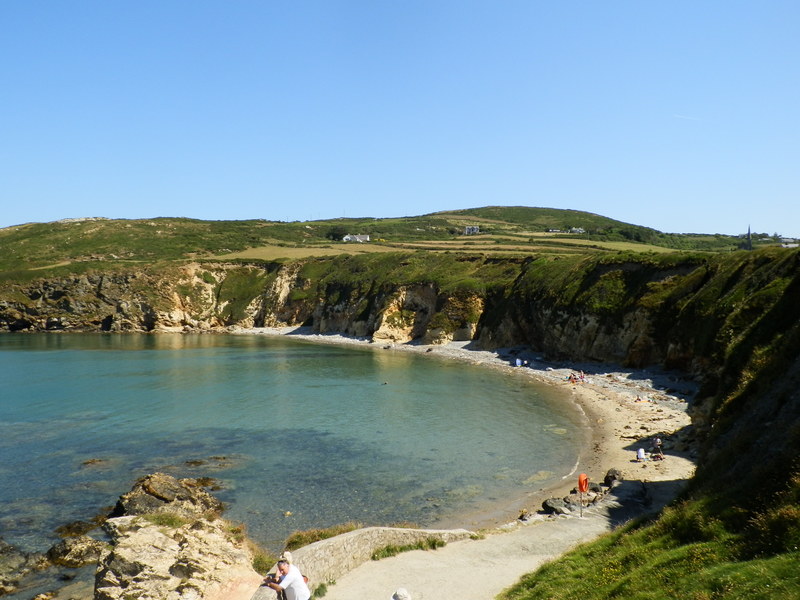
Also known as Porth Swtan, the bay is located on the north coast of Anglesey, facing
west overlooking Holyhead. The beach consists of rock, pebble and sand, backed by
cliffs, edged by rocks with many rock pools. Church Bay falls within the Anglesey
Area of Outstanding Natural Beauty, with the Clegir Mawr Site of Special Scientific
Interest located at the north of the bay. It also lies within the Anglesey Heritage
Coast designation. The water quality sample point is located at the centre of the
bay.
|
 |
| county name |
Isle of Anglesey |
|
| history statement |
Natural Resources Wales has developed a good working relationship with Dŵr Cymru Welsh
Water and liaises regularly to identify problems that could affect bathing water quality.
|
|
| investigations statement |
Natural Resources Wales works to establish sources of pollution around Church Bay.
Some of this work is carried out in partnership with Anglesey County Council and Dŵr
Cymru Welsh Water. Inspections are carried out by Natural Resources Wales in partnership
with the local authority and the water company. These are carried out pre-season (before
the 1st of May) and mid season, if required (during the bathing water season).
Pollution prevention visits to private properties (both trade and domestic) have been
carried out in 2010 to deal with their septic tank discharges.
|
|
| local authority statement |
Natural Resources Wales continues to work with Anglesey Council to maintain the high
standard of water quality at Church Bay.
|
|
| macro algae statement |
This bathing water does not have a history of large amounts of seaweed (macroalgae). |
|
| misconnections statement |
Modern sewerage systems have two separate systems, one takes foul sewage to sewage
treatment, the other takes rainwater runoff through surface water drains to rivers,
lakes and the sea. Misconnections occur when waste water pipes are plumbed into surface
water drains instead of the foul water sewerage system. This can give rise to pollution
when the waste water is discharged directly to the environment through the surface
water drain. For example, a washing machine or toilet may be incorrectly plumbed so
that it discharges to the surface drain rather than the foul sewage drain.
|
|
| phytoplankton statement |
Phytoplankton (microscopic algae) naturally increase in number at certain times of
the year. This process is known as a phytoplankton bloom.
Algal Blooms can occur at any beach during the bathing season and are usually noticeable
by a surface scum. This beach has no history of such blooms.
|
|
| source |
|
| stw outfalls statement |
Rhydwyn Sewage Treatment Works is located inland above the cliffs, approximately 1.2
kilometres from the beach. This discharges secondary treated sewage to a small watercourse,
which drains to a small bay more than 0.5 kilometres south of Church Bay.
|
|
| version string |
1 |
|
| zoi description |
The natural drainage (hydrological) catchment surrounding the bathing water is primarily
rural. Most is agricultural land with pasture and some rough grazing on the cliffs.
The land above the cliffs is relatively flat, with isolated dwellings scattered throughout
the upper catchment.
|
|
| bathing water |
ukl1100-40030 |
|
| local authority |
Sir Ynys Mon - Isle of Anglesey |
|
| standard language collection |
2014-40030:1
|
|
|
| algae general statement |
Seaweed (macroalgae) and phytoplankton (microscopic algae) are a natural part of the
marine and freshwater environment. Below we note whether these have been recorded
in quantities sufficient to be a nuisance.
|
|
| eso outfalls general statement |
The majority of sewers in England and Wales are “combined sewers” and carry both sewage
and surface water from roofs and drains. A storm overflow operates during heavy rainfall
when the sewerage system becomes overwhelmed by the amount of surface water. The overflow
prevents sewage from backing up pipes and flooding properties and gardens. An emergency
overflow will only operate infrequently, for example due to pump failure or blockage
in the sewerage system.
|
|
| local authority general statement |
Heavy rain falling on pavements and roads often flows into surface water drains or
highway drains, ending up in local rivers and, ultimately, the sea. The quality of
bathing water may be adversely affected as a result of such events.
|
|
| pollution management general statement |
It is the Environment Agency and Natural Resources Wales role to drive improvement
of water quality at bathing waters that are at risk of failing European standards.
It is natural for water to run off the land to the sea. Water quality at a bathing
water is dependent upon the type and area of land (the catchment) draining to the
water and the activities undertaken in that catchment.
|
|
| stw outfalls general statement |
Discharges from sewage treatment works have improved substantially in England and
Wales since the 1980s.
|
|
|
| web res image |
ukl1100-40030_1-webres.jpg |
|