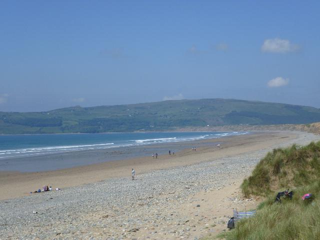
This is a large beach on the southwest facing side of the Lleyn Peninsula. It is also
known as Hell's Mouth, and is a popular spot with surfers. It is predominantly sandy
in nature, with a pebbly foreshore. The area lies within the Sea cliffs of Lleyn Site
of Special Scientific Interest and Special Area of Conservation, the Lleyn Peninsula
and the Sarnau Special Area of Conservation, and the Llyn Area of Outstanding Natural
Beauty. The water quality sample point is in line with the car park.
Modern sewerage systems have two separate systems, one takes foul sewage to sewage
treatment, the other takes rainwater runoff through surface water drains to rivers,
lakes and the sea. Misconnections occur when waste water pipes are plumbed into surface
water drains instead of the foul water sewerage system. This can give rise to pollution
when the waste water is discharged directly to the environment through the surface
water drain. For example, a washing machine or toilet may be incorrectly plumbed so
that it discharges to the surface drain rather than the foul sewage drain.
Phytoplankton (microscopic algae) naturally increase in number at certain times of
the year. This process is known as a phytoplankton bloom.
Algal Blooms can occur at any beach during the bathing season and are usually noticeable
by a surface scum. This beach has no history of such blooms.
Streams are typically affected by sewage or industrial run-off from further up the
catchment. There are a small number of unnamed streams which run onto Porth Neigwl,
however there has never been any history of sewage/runoff entering these watercourses.
There is one sewage works located at the west end of the bay which serves the village
of Rhiw. This is not known to have any impact on the bathing water quality.
Poorly maintained private sewage treatment facilities could be a source of pollution,
therefore the registration of all private sewage systems in Wales is required by 30
June 2012. The primary aim of this exercise is to provide increased protection for
the environment and sensitive features such as bathing water beaches. Where properties
are identified in the catchment that are not on mains sewerage, Natural Resources
Wales will endeavour to ensure registration has been made.
The natural drainage catchment area surrounding the bathing water is largely rural.
The majority of land is agricultural land but this tends to drain towards the Soch
due to the topography of the land. The backdrop of the beach is boulder clay, which
forms cliffs which are being eroded away.
Seaweed (macroalgae) and phytoplankton (microscopic algae) are a natural part of the
marine and freshwater environment. Below we note whether these have been recorded
in quantities sufficient to be a nuisance.
The majority of sewers in England and Wales are “combined sewers” and carry both sewage
and surface water from roofs and drains. A storm overflow operates during heavy rainfall
when the sewerage system becomes overwhelmed by the amount of surface water. The overflow
prevents sewage from backing up pipes and flooding properties and gardens. An emergency
overflow will only operate infrequently, for example due to pump failure or blockage
in the sewerage system.
Heavy rain falling on pavements and roads often flows into surface water drains or
highway drains, ending up in local rivers and, ultimately, the sea. The quality of
bathing water may be adversely affected as a result of such events.
It is the Environment Agency and Natural Resources Wales role to drive improvement
of water quality at bathing waters that are at risk of failing European standards.
It is natural for water to run off the land to the sea. Water quality at a bathing
water is dependent upon the type and area of land (the catchment) draining to the
water and the activities undertaken in that catchment.
