Linked Data API
Show Search Form
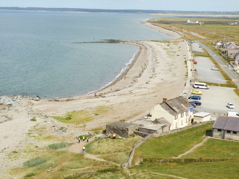
2014 Bathing Water Profile for Morfa Dinlle
http://environment.data.gov.uk/data/bathing-water-profile/ukl1200-39970/2014:1
| bathing water description | The beach is a long, west facing, stretch of sand and pebble, backed by agricultural land, camp sites and an air field in the north. Dinas Dinlle Site of Special Scientific Interest is to the south of the bathing area and Morfa Dinlle Site of Special Scientific Interest and the Abermenai to Aberffraw Dunes Special Area of Conservation to the north. The water quality sample point is located south of the beach car park. |  |
||||||||||||||||||
|---|---|---|---|---|---|---|---|---|---|---|---|---|---|---|---|---|---|---|---|---|
| county name | Gwynedd | |
||||||||||||||||||
| eso outfalls statement | There are no outfalls that discharge directly onto the beach. There is a storm overflow which discharges into the Gwyrfai. This feeds into Foryd Bay and could have an impact on Dinas Dinlle during periods of high rainfall. | |
||||||||||||||||||
| history statement | Natural Resources Wales has developed a good working relationship with Dŵr Cymru Welsh Water and liaises regularly to identify problems that could affect bathing water quality. Sewage from Dinas Dinlle is pumped to Llanfaglan, where it receives secondary treatment and final settlement prior to discharge to the River Gwyrfai, which helps protect bathing water quality. | |
||||||||||||||||||
| investigations statement | Natural Resources Wales works to establish sources of pollution around Dinas Dinlle. Some of this work is carried out in partnership with Gwynedd Council and Dŵr Cymru Welsh Water. Inspections are carried out by Natural Resources Wales in partnership with the local authority and the water company. These are carried out pre-season (before the 1st of May) and mid season, if required (during the bathing water season). | |
||||||||||||||||||
| macro algae statement | This bathing water does not have a history of large amounts of seaweed (macroalgae). | |
||||||||||||||||||
| misconnections statement | Modern sewerage systems have two separate systems, one takes foul sewage to sewage treatment, the other takes rainwater runoff through surface water drains to rivers, lakes and the sea. Misconnections occur when waste water pipes are plumbed into surface water drains instead of the foul water sewerage system. This can give rise to pollution when the waste water is discharged directly to the environment through the surface water drain. For example, a washing machine or toilet may be incorrectly plumbed so that it discharges to the surface drain rather than the foul sewage drain. | |
||||||||||||||||||
| phytoplankton statement | Phytoplankton (microscopic algae) naturally increase in number at certain times of the year. This process is known as a phytoplankton bloom. Algal Blooms can occur at any beach during the bathing season and are usually noticeable by a surface scum. This beach has no history of such blooms. | |
||||||||||||||||||
| source |
|
|||||||||||||||||||
| streams rivers statement | Streams are typically affected by sewage or industrial run off from further up the catchment. There are a number of rivers that all merge in the nearby Foryd area including the Gwyrfai, Bodafon, Plas Tan Dinas, Carrog, Rhyd, and Foryd, all of which have the potential to result in reduced water quality, after heavy rainfall. | |
||||||||||||||||||
| version string | 1 | |
||||||||||||||||||
| working with private owners statement | There are two 2 large caravan sites on the flood plain behind the beach. Both of these are served by the public sewer. Poorly maintained private sewage treatment facilities could be a source of pollution, therefore the registration of all private sewage systems in Wales is required by 30 June 2012. The primary aim of this exercise is to provide increased protection for the environment and sensitive features such as bathing water beaches. Where properties are identified in the catchment that are not on mains sewerage, Natural Resources Wales will endeavour to ensure registration has been made. | |
||||||||||||||||||
| zoi description | The natural drainage (hydrological) catchment is relatively low lying with a large area of grazing land behind the beach to the south of the bathing water. | |
||||||||||||||||||
| bathing water | ukl1200-39970 | |||||||||||||||||||
| local authority | Gwynedd - Gwynedd | |
||||||||||||||||||
| standard language collection |
|
|||||||||||||||||||
| web res image | ukl1200-39970_1-webres.jpg | |||||||||||||||||||