|
|
|
| bathing water description |
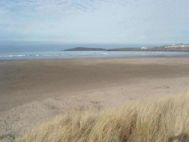
Located within Cardigan Bay and measuring approximately 600 metres in length, this
north west facing bay is backed by sand dunes and is divided by the River Teifi, which
flows onto the beach. The land surrounding the beach is predominantly agricultural,
with the town of Cardigan located approximately 3 kilometres south east of Poppit
Sands. The coastal waters and coastal belt form part of the Cardigan Bay Special Area
of Conservation, confirming the high conservation status of the area. The bathing
water also lies within Pembrokeshire Coast National Park. The water quality sample
is located at the centre of the beach, to the north of the car park.
|
 |
| county name |
Pembrokeshire |
|
| eso outfalls statement |
Discharges from storm overflows can occur within the vicinity of the bathing water.
These discharges occur when heavy rainfall overwhelms the sewage system and causes
diluted sewage to spill. They protect domestic properties in Cardigan from being flooded
by sewage during periods of heavy rainfall.
|
|
| history statement |
Natural Resources Wales has developed a good working relationship with Dŵr Cymru Welsh
Water and liaises regularly to identify problems that could affect bathing water quality.
|
|
| investigations statement |
Natural Resources Wales continues to work with Pembrokeshire and Ceredigion County
Council and Dŵr Cymru Welsh Water to identify sources of pollution that may impact
on Poppit Sands.
Inspections are carried out by Natural Resources Wales in partnership with the local
authority and the water company. These are carried out pre-season (before the 1st
of May) and mid-season, if required (during the bathing water season).
|
|
| local authority statement |
Natural Resources Wales, Pembrokeshire and Ceredigion County Council have been working
together to improve the bathing water quality at Poppit Sands for a number of years.
|
|
| macro algae statement |
This bathing water does not have a history of large amounts of seaweed (macroalgae). |
|
| misconnections statement |
Wrongly connected waste water pipes affect the water quality of rivers and the sea.
Any misconnections are investigated by the local authority.
Modern sewerage systems have two separate systems, one takes foul sewage to sewage
treatment, the other takes rainwater runoff through surface water drains to rivers,
lakes and the sea. Misconnections occur when waste water pipes are plumbed into surface
water drains instead of the foul water sewerage system. This can give rise to pollution
when the waste water is discharged directly to the environment through the surface
water drain. For example, a washing machine or toilet may be incorrectly plumbed so
that it discharges to the surface drain rather than the foul sewage drain.
|
|
| phytoplankton statement |
Phytoplankton (microscopic algae) naturally increase in number at certain times of
the year. This process is known as a phytoplankton bloom. These algal blooms can occur
at any beach during the bathing season and are usually noticeable by a surface scum.
This beach has a history of such blooms.
|
|
| source |
|
| stw outfalls statement |
A main focus of the pre-season inspections is the sewage system serving the town of
Cardigan. The sewage treatment works uses ultra violet disinfection to provide a high
quality effluent. This protects the quality of the bathing water. The discharge from
the works is regulated by an Environmental Permit, setting strict physical, biological
and chemical standards that must be met.
There are several continuous treated sewage effluent discharges from towns and villages
to the River Teifi, with the most significant being Cardigan. Other notable discharges
occur from the towns of Tregarron, Lampeter and Newcastle Emlyn.
|
|
| version string |
1 |
|
| zoi description |
The natural drainage (hydrological) catchment surrounding the bathing water is predominantly
agricultural, with the large residential town of Cardigan located 3 km in land of
Poppit. The River Teifi is one of the largest in mid-Wales, draining a large agricultural
catchment that begins in The Cambrian Mountains. There are several villages and towns
located along its course, all of which can affect the water quality with runoff from
the urban areas.
|
|
| bathing water |
ukl1402-38630 |
|
| local authority |
Sir Benfro - Pembrokeshire |
|
| standard language collection |
2014-38630:1
|
|
|
| algae general statement |
Seaweed (macroalgae) and phytoplankton (microscopic algae) are a natural part of the
marine and freshwater environment. Below we note whether these have been recorded
in quantities sufficient to be a nuisance.
|
|
| eso outfalls general statement |
The majority of sewers in England and Wales are “combined sewers” and carry both sewage
and surface water from roofs and drains. A storm overflow operates during heavy rainfall
when the sewerage system becomes overwhelmed by the amount of surface water. The overflow
prevents sewage from backing up pipes and flooding properties and gardens. An emergency
overflow will only operate infrequently, for example due to pump failure or blockage
in the sewerage system.
|
|
| local authority general statement |
Heavy rain falling on pavements and roads often flows into surface water drains or
highway drains, ending up in local rivers and, ultimately, the sea. The quality of
bathing water may be adversely affected as a result of such events.
|
|
| pollution management general statement |
It is the Environment Agency and Natural Resources Wales role to drive improvement
of water quality at bathing waters that are at risk of failing European standards.
It is natural for water to run off the land to the sea. Water quality at a bathing
water is dependent upon the type and area of land (the catchment) draining to the
water and the activities undertaken in that catchment.
|
|
| stw outfalls general statement |
Discharges from sewage treatment works have improved substantially in England and
Wales since the 1980s.
|
|
|
| web res image |
ukl1402-38630_1-webres.jpg |
|