|
|
|
| label |
| 2014 Bathing Water Profile for Aberafan |
 |
|
| bathing water description |
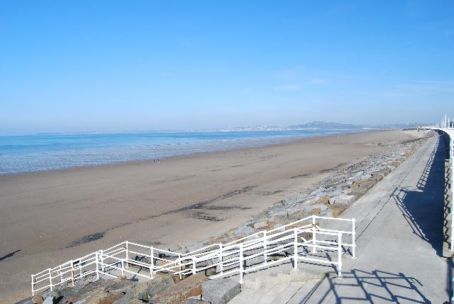
Beyond the sea defence and sand dunes, a gently sloping, 4 kilometre long sandy beach
extends to the sea. The beach faces south west into Swansea Bay and is located between
two large rivers, the River Neath to the north west and River Afan to the south east.
Directly behind the beach, is the industrial town of Port Talbot. The water quality
sample point is located opposite the roundabout along the sea front, off the slip
near the coastguard station.
|
|
| county name |
Neath Port Talbot |
|
| eso outfalls statement |
There are no direct discharges from the sewage network onto the bathing beach. However,
there are several sewage pumping stations with emergency and storm overflows located
within in the tidal zones of the Rivers Afan and Neath. These protect domestic properties
in Aberafan from being flooded by sewage and storm water during heavy rainfall. There
could be an adverse impact on bathing water quality following periods of heavy rainfall,
when these discharges operate.
|
|
| history statement |
Natural Resources Wales works closely with Dŵr Cymru Welsh Water to identify, investigate
and resolve problems affecting bathing water quality.
|
|
| investigations statement |
Natural Resources Wales works with Neath Port Talbot County Borough Council, Dŵr Cymru
Welsh Water and privately permitted discharge consent holders to establish sources
of pollution affecting water quality at Aberafan bathing water.
Inspections are carried out by Natural Resources Wales in partnership with the local
authority and the water company. These are carried out pre-season (before the 1st
of May) and mid season if required (during the bathing water season).
|
|
| local authority statement |
Immediately behind Aberafan bathing water are Sandfields and Aberafan, urban areas
of Port Talbot. These areas are served by a combined surface water and sewer system,
but this does not discharge onto the beach.
|
|
| macro algae statement |
This bathing water does not have a history of large amounts of seaweed (macroalgae). |
|
| misconnections statement |
Wrongly connected waste water pipes have been identified in other urban areas further
upstream in the bathing water catchment. These can have a detrimental impact on the
bathing water quality. Natural Resources Wales is working with Neath Port Talbot council
and Dŵr Cymru Welsh Water to identify and resolve these sources of pollution.
Modern sewerage systems have two separate systems, one takes foul sewage to sewage
treatment, the other takes rainwater runoff through surface water drains to rivers,
lakes and the sea. Misconnections occur when waste water pipes are plumbed into surface
water drains instead of the foul water sewerage system. This can give rise to pollution
when the waste water is discharged directly to the environment through the surface
water drain. For example, a washing machine or toilet may be incorrectly plumbed so
that it discharges to the surface drain rather than the foul sewage drain.
|
|
| phytoplankton statement |
Phytoplankton (microscopic algae) naturally increase in number at certain times of
the year. This process is known as a phytoplankton bloom. These algal blooms can occur
at any beach during the bathing season and are usually noticeable by a surface scum.
This beach has a history of such blooms.
|
|
| source |
|
| stw outfalls statement |
Two large wastewater treatment works discharge their final effluent into Swansea Bay,
via long sea outfalls. One of these works has ultra-violet treatment, which is designed
to reduce the levels of bacteria in the final effluent, which will help to improve
bathing water quality. These works also have emergency and storm outlets which, when
operating will discharge screened effluent into Swansea Bay. There are also seven
smaller sewage treatment works located along the length of the River Neath which also
have storm and/or emergency overflows.
|
|
| type |
|
| version string |
1 |
|
| zoi description |
The natural drainage (hydrological) catchment surrounding the bathing water is highly
diverse. The towns of Neath and Port Talbot are located in the lower catchment of
the bathing water, with several smaller urban areas located along the length of the
two rivers. These urban areas comprise a mixture of residential and light industrial
land use. There is also substantial heavy industry to the south east of the beach
incorporating a large deepwater dock with associated shipping traffic. Higher up in
the catchment, there are large areas of forestry land, active mines and upland hill
farming (predominantly sheep).
|
|
| applicable year |
British Year:2014 |
|
| bathing water |
ukl1702-36800 |
|
| interval |
interval |
|
| is version of |
2014 |
|
| local authority |
Castell-nedd Port Talbot - Neath Port Talbot |
|
| standard language collection |
2014 Bathing Water Profile Standard Language |
|
| web res image |
ukl1702-36800_1-webres.jpg |
|