Hurst Spit to Durlston Head SMP15
General actions for this SMP
This shows the actions generic to the whole of this SMP. For further actions relating to specific locations, select an area on the map above or use the postcode/location search and click on the Action Plan tab.
All actions are subject to funding and approval, often by other parties than the Lead Organisation shown.
| Reference Number | Action Description | Action Lead Organisation | Action Progress Status | Priority |
|---|---|---|---|---|
| 15.01 | Define review process, including management approach implementation and maintaining the Action Plan. | Bournemouth, Christchurch and Poole Council | Complete | High |
| 15.01.01 | Produce new Action Plans in line with new Supplementary SMP Guidance | Bournemouth, Christchurch and Poole Council | Complete | Medium-high |
| 15.12.01 | Develop adaptation pathways and trigger levels/decision points (including visual representation) for all units in SMP15, with areas of potential or planned transition in management approach a priority. | Bournemouth, Christchurch and Poole Council | Not yet started | Medium-high |
| 15.12.02 | Review (and extend if necessary) South East Regional Coastal Monitoring Programme to correspond with and inform trigger level assessments. | Bournemouth, Christchurch and Poole Council | Not yet started | Medium-high |
| 15.14.01 | Engage with and input to new Local Plans for Dorset and Bournemouth, Christchurch and Poole Council areas and develop coastal change adaptation plans/risk planning guidance as part of this. | Bournemouth, Christchurch and Poole Council | Progressing | Medium-high |
| 15.31 | Develop a Strategic Communications and Engagement Plan to ensure the SMP has profile with those making investment and planning decisions, and is used and understood by those living or working at the coast (or seeking to do so) within the SMP area. | Bournemouth, Christchurch and Poole Council | Progressing | Medium-high |
| 15.39.02 | Deliver Bournemouth Beach Improvement Scheme 5 beach recharging | Bournemouth, Christchurch and Poole Council | Complete | Medium-high |
| 15.01.02 | Conduct an annual review of the SMP 15 Action Plan led by Bournemouth, Christchurch and Poole (BCP) Council and reported to Southern Coastal Group (SCG) and SMP 15 Management Group. | Bournemouth, Christchurch and Poole Council | Progressing | Medium |
| 15.05 | Develop a new Christchurch Bay & Harbour FCERM Strategy that is approved by the Environment Agency, updating from 2012 unapproved version and accounting for more recent evidence and guidance. | Bournemouth, Christchurch and Poole Council | Progressing | Medium |
| 15.05.03 | Investigate realignment options for the medium to long term, including technical (defence sustainability), economic, social and environmental considerations at both Milford-on-Sea and Barton-on-Sea. | Bournemouth, Christchurch and Poole Council | Progressing | Medium |
| 15.09 | Develop and maintain the Durlston to Hurst Sediment Resource Management Programme (previously called the SMP-wide Beach Management Plan), to investigate topics such as sediment sources, beach recycling, sediment paths off beaches to sinks (including offshore dynamics of offshore banks) and future partnership efficiencies. | Bournemouth, Christchurch and Poole Council | Progressing | Medium |
| 15.09.01 | Review findings of the 2019 SMP-Wide Beach Management Study for implications for SMP policy or delivery. | Bournemouth, Christchurch and Poole Council | Progressing | Medium |
| 15.12 | Pilot development of adaptation pathways and define trigger levels (including visual representation) for decision points at Brownsea Lagoon. | Bournemouth, Christchurch and Poole Council | Progressing | Medium |
| 15.13 | Develop a programme to engage planners to raise awareness of the SMP Refresh process recommendations and overall management intent, and discuss issues around coastal change on (cliffed) Hold the Line frontages. | Bournemouth, Christchurch and Poole Council | Progressing | Medium |
| 15.13.01 | Consider if new evidence/information is available to keep Local Planning Authorities' GIS planning portals up to date. | Bournemouth, Christchurch and Poole Council | Not yet started | Medium |
| 15.14 | Ensure that Local Plan documents take account of SMP policies and flood and erosion risks, including defining Coastal Change Management Areas (CCMAs). | Bournemouth, Christchurch and Poole Council and New Forest District Council | On hold | Medium |
| 15.16 | Identify potential areas of habitat creation and restoration that could be delivered through Local Nature Recovery Strategies, for Biodiversity Net Gain from development planning, and other initiatives, and align these with the Habitat Compensation and Restoration Programme. | Environment Agency | Progressing | Medium |
| 15.29 | Work with relevant Environment Agency staff to ensure that SMP management intent (including revisions or potential revisions to it) is reflected in second cycle Flood Risk Management Plans locally, and ensure SMPs are reflecting the opportunities to meet the objectives set out in River Basin Management Plans in Transitional and Coastal Waters. | Bournemouth, Christchurch and Poole Council | Complete | Medium |
| 15.31.01 | Establish a communications and engagement approach to ensure that elected members of local councils are aware of and understand the management approaches agreed in the SMP, and the opportunities and implications for their local area. | Bournemouth, Christchurch and Poole Council | Progressing | Medium |
| 15.37 | Develop a new BCP-wide Cliff Management Strategy | Bournemouth, Christchurch and Poole Council | Progressing | Medium |
| 15.39.03 | Deliver Hengistbury Head Long Groyne replacement | Bournemouth, Christchurch and Poole Council | Progressing | Medium |
| 15.39.04 | Deliver Bournemouth Beach Improvement Scheme 6 beach recharging | Bournemouth, Christchurch and Poole Council | Not yet started | Medium |
| 15.01.03 | Identify all new (since 2010) environmental designations in SMP 15 area and assess relevance to SMP management approaches. If necessary, trigger additional review of SMP units (where not already considering this) and update SMP action plan as appropriate with any actions that review identifies. | Bournemouth, Christchurch and Poole Council | Complete | Medium-low |
| 15.02.01 | Undertake an annual review of the South East Regional Coastal Monitoring Programme to adjust monitoring programme to reflect changing needs etc., informed by more recent studies etc. | Bournemouth, Christchurch and Poole Council | Not yet started | Medium-low |
| 15.15 | Carry out a strategic-level review of the Habitats Regulations Assessment of the SMP to ensure it reflects any changes made to the Plan’s management intent or impacts of existing management intent on newly designated protected European Sites. | Bournemouth, Christchurch and Poole Council | Not yet started | Medium-low |
| 15.16.01 | Identify potential opportunities for statutory habitat compensation and take forward through the regional Habitat Compensation and Restoration Programmes and/or Local Nature Recovery Strategies covering the SMP area. | Environment Agency and Bournemouth, Christchurch and Poole Council | Progressing | Medium-low |
| 15.28 | Work with relevant Marine Management Organisation staff to identify within Marine Plans any key potential risks to delivery of SMP management intent, and identify potential responses. Produce brief note on this review and update SMP action plan as appropriate with any actions that review identifies. | Bournemouth, Christchurch and Poole Council | Complete | Medium-low |
| 15.30 | Review the 2014 Poole Bay, Poole Harbour & Wareham FCERM Strategy | Bournemouth, Christchurch and Poole Council | Not yet started | Medium-low |
| 15.32 | Develop a Sandbanks to Hengistbury Head Beach Management Plan, then ensure the BMP Action Plan is being implemented. Review & update the BMP every 5 years. | Bournemouth, Christchurch and Poole Council | Progressing | Medium-low |
| 15.39.01 | Deliver Bournemouth frontage timber groyne replacement programme | Bournemouth, Christchurch and Poole Council | Progressing | Medium-low |
| 15.44 | Develop and deliver Christchurch Harbour Tidal Defence Scheme | Bournemouth, Christchurch and Poole Council | Not yet started | Medium-low |
| 15.01.04 | Ensure the SMP15 Environmental Designation Review document is being kept up to date, working with Heritage England and Natural England, as and when changes are made to SMP15 policies or environmental designations. | Bournemouth, Christchurch and Poole Council | Progressing | Low |
| 15.02 | Support continuation of the South East Regional Coastal Monitoring Programme. This in turn will support ongoing implementation of SMP policy, including monitoring of trigger points once defined by the SMP. | Bournemouth, Christchurch and Poole Council | Progressing | Low |
| 15.03 | Implement comprehensive monitoring programme for cliff top erosion across the SMP15 area. This information should not only be used in future coastal management by informing future updates of the National Coastal Erosion Risk Mapping, but also to assist in stakeholder liaison by use of data in public education campaigns. | Channel Coastal Observatory | Progressing | Low |
| 15.03.01 | Undertake detailed monitoring of erosion of cliffs at Barton on Sea. | New Forest District Council | Progressing | Low |
| 15.04 | Undertake a review of laser-scan data from the South East Regional Coastal Monitoring Programme to assess changes in cliff areas that have been captured as incidental data within baseline/asset surveys. | Channel Coastal Observatory | Not yet started | Low |
| 15.05.01 | Undertake ongoing monitoring to ensure that the processes at Mudeford Sandbank are consistent with assumptions made in the SMP2. | Bournemouth, Christchurch and Poole Council | Progressing | Low |
| 15.07 | Undertake study to determine role and management options of secondary defences, involving the Environment Agency and Local Authority planners. | New Forest District Council | Progressing | Low |
| 15.08 | Continue with monitoring programme at Boscombe surf reef (20 year life). | Bournemouth, Christchurch and Poole Council | Progressing | Low |
| 15.09.02 | Monitor the SMP area to identify the accuracy of modelled predictions of flooding and erosion against actual events. | Bournemouth, Christchurch and Poole Council | Progressing | Low |
| 15.09.03 | Monitor beach material particle size distribution periodically to observe potenital changes along SMP frontages. | Bournemouth, Christchurch and Poole Council | Progressing | Low |
| 15.10 | Update the 2012 SCOPAC Sediment Transport Study (STS) to include new baseline data captured in 2022/23 from the Regional Coastal Monitoring Programme and other recent studies. | Southern Coastal Group/SCOPAC | Not yet started | Low |
| 15.11 | Use Regional Coastal Monitoring Programme data to make improvements to historical coastal evolution studies (especially in western part of SMP) to identify impacts of coastal change based on aerial surveys, in partnership with SMPs for North Solent, Isle of Wight and South Devon to Dorset. | Coastal Partners | Progressing | Low |
| 15.16.02 | Update projections of habitat change using evidence from the Regional Coastal Monitoring Programme and local studies to inform the Habitat Compensation and Restoration Programmes covering Wessex and North Solent. | Environment Agency | On hold | Low |
| 15.16.03 | Carry out further investigations to identify potential sites to recreate compensatory intertidal habitat and obstacles that may need to be overcome. | Environment Agency | Progressing | Low |
| 15.16.04 | Further investigation into compensatory requirements needed as a result of managed realignment option resulting in an adverse effect on terrestrial European Sites including heathland and grassland. | Environment Agency | Not yet started | Low |
| 15.16.05 | Carry out monitoring to ensure that the intertidal development trends are consistent with assumptions made in the SMP. | Environment Agency | Progressing | Low |
| 15.28.01 | Ensure the SMP15 - South Marine Plan comparison document is being used by members of the SMP15 Management Group in progressing projects, and being kept up to date, working with Marine Management Organisation staff. | Bournemouth, Christchurch and Poole Council | Progressing | Low |
| 15.33 | Ensure Swanage BMP (2020) Action Plan is being implemented. | Dorset Council | Progressing | Low |
| 15.33.01 | Undertake 5-year review & update of Swanage Beach Management Plan (2020) | Dorset Council | Not yet started | Low |
| 15.16.08 | Update the Strategic Environmental Assessment for the SMP to ensure it reflects any changes made to the Plan’s management intent or impacts of existing management intent on Highly Protected Marine Areas, Marine Conservation Zones and SSSIs. | SMP15 Management Group |
Download SMP documents
The information on this website represents the current SMP management approaches adopted by the local authorities within its area, and current actions needed to deliver them. These management approaches have been approved by the Environment Agency under its Strategic Overview for coastal flood and erosion risk management and are considered to be local policy.
The documents below provide the full SMP adopted locally and approved by the Environment Agency at the time of publication. Some of the information has changed in response to new government policy, new evidence or new work identified.
Data on this page
Main report
Appendices
- Appendix A - SMP Development
- Appendix B - Stakeholder Engagement
Appendix C - Baseline Process Understanding:
- Appendix D - Natural and Built Environment Baseline (Thematic Review)
- Appendix E - Issues and Objectives
- Appendix F - Strategic Environmental Assessment
- Appendix G - Scenario Testing
- Appendix H - Economics
- Appendix I - Estuary Assessment1
- Appendix J - Habitat Regulation Assessment
- Appendix K - Metadatabase
- Appendix L - Water Framework Directive
- Appendix M - Review of Hengistbury Head
- Appendix N - Client Steering Group Approvals
About this SMP
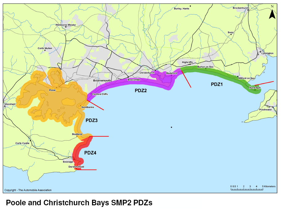
This Shoreline Management Plan (SMP) covers the length of coast between The Hurst Split to Durlston Head.
You can read the full SMP document by selecting the Download tab. This SMP was completed in 2011 and received formal adoption and sign off from relevant local authorities and the Environment Agency.
Managing shorelines in this area
The SMP for this area presents agreed approaches to managing the risk of coastal flooding and erosion at the shoreline and in estuaries over the short, medium, and long term, considering the implications of climate change.
In some locations, the approaches set out in the SMP change over time, for example from holding the current shoreline position with defences to realigning it or allowing the coast to change more naturally.
The SMP shows where this may affect people, property or the natural environment and the action plan includes measures to manage the local effects of coastal change. Local development planning can then be used to help avoid or address these effects, for example by identifying where new or relocated buildings can be built and defining any conditions to promote safety or sustainability. More localised Coastal Strategies may also be developed to identify how the approach in the SMP should be funded and implemented in more detail. You can find these under the Related Links tab for the SMP.
The objectives of the SMP can be found in the national SMP Guidance document (Volume 1, section 2.1). In summary, they are to identify preferred approaches for:
- managing flood and erosion risk to existing properties and other assets
- identifying approaches that are economically, technically and environmentally sustainable
- protecting and enhancing the natural features and character of the coast through these approaches where possible
Managing inland flood risk
To find out more about managing future flood risk inland, see the Flood Risk Management Plan.
Developing this SMP
The group that developed and agreed this SMP included:
- Bournemouth Christchurch and Poole Council (previously Bournemouth Borough Council, Christchurch Borough Council, Poole Borough Council & Dorset County Council)
- Dorset Council (previously Purbeck District Council & Dorset County Council)
- New Forest District Council
- Hampshire County Council
- Environment Agency
- National Trust
- Natural England
- Poole Harbour Commissioners
The group consulted the public and engaged with a range of stakeholders interested in the area’s coastal management while developing this SMP. The SMP was approved by the Environment Agency and formally adopted by each local authority. You can find further details of how the group developed the SMP in Appendix A of the document. This can be found by selecting the Download tab.